|
Proper Municipality Name |
Community Name |
Distance* |
Intersecting Road |
|
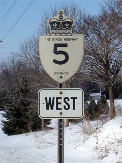
In (the City of) Brant County,
Highway 5 is known as Brant Highway 5 |
| City of Brant County |
Paris |
--- (0km) / --- (113.8km) |
Highway 2 (Brant
Road 2) |
| City of Brant County |
(Former) Paris East Limits |
--- (0.4km) / --- (113.4km) |
----- |
|
At Highway 24-South: EB: Turn
left towards Cambridge onto Highway 24. WB: Follow the ramp to the right towards Paris to stay on
Highway 5. |
| City of Brant County |
Osborne Corners |
--- (6.8km) / --- (107.0km) |
King's Highway 24-South & Highway 99
(Brant Road 99) |
|
At Highway 24-North: EB: At Highway 5 east take the
ramp ramp right towards St. George. WB: At Highway 24 turn left
towards Brantford |
| City of Brant County |
----- |
--- (10.3km) / --- (103.5km) |
King's Highway 24-North & Brant Road 35 |
| City of Brant County |
St. George |
--- (13.4km) / --- (100.4km) |
St. George Road (Brant Road 13) |
| Brant - Hamilton Boundary |
----- |
--- (16.5km) / --- (97.3km) |
----- |
|
City of Hamilton - Highway 5 is
not signed as anything in Hamilton, it is suspected that will be resigned to
Hamilton Road 5 in the future. |
| City of Hamilton |
Troy |
--- (19.2km) / --- (94.6km) |
Sheffield Road (Formerly Hamilton Road 535) |
| City of Hamilton |
----- |
--- (21.7km) / --- (92.1km) |
Lynden Road (Formerly Hamilton Road 503) |
| City of Hamilton |
----- |
--- (24.1km) / --- (89.7km) |
Kirkwall Road (Formerly Hamilton Road 552) |
| City of Hamilton |
Peters Corners |
--- (29.0km) / --- (84.8km) |
Highway 52 (Hamilton
Road 52) |
|
Current Western Terminus of
Highway 5 is located at Highway 8 |
| City of Hamilton |
Peters Corners |
0km (29.2km) / 12.6km (84.6km) |
King's Highway 8 / Hamilton Road 8 |
| City of Hamilton |
----- |
5.6km (34.8km) / 7.1km (79.0km) |
Brock Road (Formerly Hamilton Road 504) |
| City of Hamilton |
----- |
9.6km (38.8km) / 3.0km (75.0km) |
Sydenham Road (Formerly Hamilton Road
505-South) |
| City of Hamilton |
----- |
9.8km (39.0km) / 2.8km (74.8km) |
Milgrove Road (Formerly Hamilton Road
505-North) |
| City of Hamilton |
Clappison's Corners |
12.6km (41.8km) / 0km (72.0km) |
King's Highway 6 |
|
Current Eastern Terminus of Highway 5 is located at
Highway 6 |
|
East of Highway 6, Highway 5 is known once again as
Hamilton Road 5 |
| City of Hamilton |
Waterdown |
--- (44.5km) / --- (69.3km) |
Hamilton Road (Formerly Hamilton Road 508) |
| City of Hamilton |
Waterdown |
--- (44.9km) / --- (68.9km) |
Mill Street (Formerly Hamilton Road 509) |
| City of Hamilton |
----- |
--- (47.1km) / --- (66.7km) |
Evans Sideroad (Formerly Hamilton Road 542) |
|
Hamilton/Halton Boundary -
Highway 5 is known as Halton Road 5 in the Regional Municipality of Halton.
Highway 5 is known as Hamilton Road 5 in Hamilton |
| Hamilton - Burlington Boundary |
Hamilton - Burlington Limits |
--- (47.6km) / --- (66.2km) |
----- |
| City of Burlington |
Burlington |
--- (49.1km) / --- (64.7km) |
Halton Road 18 (Brant Street & Cedar Spring's Road) |
| City of Burlington |
Burlington |
--- (51.1km) / --- (62.7km) |
Guelph Line (Halton Road 1) |
| City of Burlington |
Burlington |
--- |
Highway 407 ETR |
| City of Burlington |
Burlington |
--- |
Walkers Line |
| City of Burlington |
Burlington |
--- |
Appleby Line |
| Burlington - Oakville Boundary |
----- |
--- (57.2km) / --- (56.6km) |
Tremaine Road (Halton Road 22) |
| Town of Oakville |
Palmero |
--- (59.3km) / --- (54.5km) |
Highway 25 (Halton road 25) |
| Town of Oakville |
----- |
--- |
3rd Line |
| Town of Oakville |
Oakville |
--- |
Neyagawa Road |
| Town of Oakville |
Trafalgar |
--- (66.6km) / --- (47.2 km) |
Trafalgar Road (Halton Road 3) |
| Oakville - Mississauga Boundary |
----- |
--- (70.0km) / --- (43.8km) |
King's Highway 403 |
|
Halton/Peel Boundary - In
Mississauga (Peel), Highway 5 is known only as Dundas Street. In
Halton, Highway 5 is now known as Halton Road 5 |
| Oakville - Mississauga Boundary |
Mississauga |
--- (71.5km) / --- (42.3km) |
Winston Churchill Boulevard (Halton Road 19) |
| City of Mississauga |
Mississauga |
--- (73.6km) / --- (40.2km) |
Erin Mills Parkway (Peel Road 1) |
| City of Mississauga |
Mississauga |
--- |
Mississauga Road |
| City of Mississauga |
Mississauga |
--- |
Mavis Road |
| City of Mississauga |
Cooksville |
--- (80.0km) / --- (33.8km) |
Highway 10 (Hurontario Street) |
| City of Mississauga |
Mississauga |
--- (82.1 km) / --- (31.7km) |
Cawthra Road (Peel Road 17) |
| City of Mississauga |
Mississauga |
--- (84.2km) / --- (29.6km) |
Dixie Road (Peel Road 4) |
| Mississauga - Toronto Boundary |
Mississauga - Toronto (Etobicoke)
Limits |
--- (86.8km) / --- (27.0km) |
----- |
| City of Toronto |
Etobicoke |
--- (87.4 km) / --- (26.4 km) |
King's Highway 427 |
|
At the Kipling Road Interchange
in Etobicoke: EB: Highway 5 becomes Bloor Street. WB:
Highway 5 becomes Dundas Street |
| City of Toronto |
Etobicoke |
--- (89.8 km) / --- (24.0km) |
Dundas Street & Bloor Street & Kipling Avenue |
| City of Toronto |
Etobicoke |
--- (90.8km) / --- (23.0km) |
Islington Avenue |
| City of Toronto |
Etobicoke |
--- (91.7km) / --- (22.1km) |
Royal York Road |
| City of Toronto |
(Former) Etobicoke -
Toronto Limits |
--- (93.3km) / --- (20.5km) |
----- |
| City of Toronto |
Toronto |
--- (93.8km) / --- (20.0km) |
South Kingsway |
| City of Toronto |
Toronto |
--- (94.0km) / --- (19.8km) |
Jane Street |
| City of Toronto |
Toronto |
--- (96.1km) / --- (17.7km) |
Keele Street & Parkside Drive |
| City of Toronto |
Toronto |
--- (96.7km) / --- (15.6km) |
Dundas Street |
| City of Toronto |
Toronto |
--- (98.2km) / --- (15.6km) |
Dufferin Street |
| City of Toronto |
Toronto |
--- (100.1km) / --- (13.7km) |
Bathurst Street |
| City of Toronto |
Toronto |
--- (100.8km) / --- (13.0km) |
Spadina Avenue |
| City of Toronto |
Toronto |
--- |
Highway 11A (Avenue Road & Queen's Park Drive) |
| City of Toronto |
Toronto |
--- |
Bay Street |
| City of Toronto |
Toronto |
--- (102.2km) / --- (11.6km) |
Highway 11 (Yonge Street) |
| City of Toronto |
Toronto |
--- (102.9km) / --- (10.9km) |
Jarvis Street (& Mount Pleasant Avenue) |
| City of Toronto |
Toronto |
--- |
Parliament Street |
|
At the Price Edward Viaduct (Don Valley Parkway):
EB: Highway 5 becomes known as Danforth Avenue. WB: Highway 5
becomes known as Bloor Street. |
| City of Toronto |
Toronto |
--- (104.8km) / --- (9.0km) |
Don Valley Parkway |
| City of Toronto |
Toronto |
--- (104.9km) / --- (8.9km) |
Broadview Avenue |
| City of Toronto |
Toronto |
--- (106.1km) / --- (7.7km) |
Pape Avenue |
| City of Toronto |
Toronto |
--- (107.8km) / --- (6.0km) |
Coxwell Avenue |
| City of Toronto |
Toronto |
--- (108.8km) / --- (5.0km) |
Woodbine Avenue |
| City of Toronto |
(Former) Toronto -
Scarborough Limits |
--- (110.6km) / --- (3.2km) |
----- |
| City of Toronto |
Scarborough |
--- (110.9km) / --- (2.9km) |
Victoria Park Avenue |
| City of Toronto |
Scarborough |
--- (111.9km) / --- (1.9km) |
Danforth Road |
| City of Toronto |
Scarborough |
--- (112.2km) / --- (1.6km) |
Warden Avenue |
| City of Toronto |
Scarborough |
--- (113.8km) / --- (0km) |
Highway 2
(Kingston Road) |
|
Highway 5 ENDS |