AsphaltPlanet.ca > OntHighways > Highway 52 > Images
< Hwy 51    Hwy 53 >

King's Highway 52 - www.OntHighways.com

Highway 52 was a short highway that ran from Highway 2/53 just west of Duff's Corners northerly to Highway 8 at Peters Corners.  Despite serving as part of the major route between Cambridge and Hamilton, Highway 52 was effectively entirely downloaded in 1998.  Only a very short section of Highway 52 still exists, this section lies between Highways 5 and 8 in Peters Corners.  The remainder of Highway 52 has been designated Hamilton Road 52.


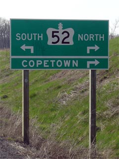
King's Highway 52 Directional Sign


Southern Terminus:  Pre-1997:  Junction Highway 2/53 west of Duff's Corners
                                         Current:  Junction Highway 5 at Peters Corners

Northern Terminus:  Junction Highway 8 at Peters Corners

Length:  Pre-1998: 10.5 km.  Current: 200m.

Multiplexes: None

Freeway: No

AADT (1994):  Highest:  6,000, from Highway 2/53 northerly to Governors Road;

                             Lowest:  5,900, from Governors Road northerly to Highway 8 at Peters Corners.

Status:  (Effectively) totally downloaded in 1998.  Now known as Hamilton Road 52.

Road Info:  Highway 52 is in fair condition for its entire length.  The highway is actually a fairly important road, given that it links Peter's Corners directly with Highway 403 near Ancaster.  That said, it was however, not well maintained by the province.  The right of way, and subsequently the road surface and shoulders are very narrow.  The City of Hamilton has tried to correct this with the resurfacing of the highway, however the cleared right of way is still quite narrow, and the new driving surface is not much wider.  Hamilton does not do a very good job designing or maintaining its county road network.  Much of Highway 52 has a posted speed limit of 70km/h, and with a high volume of trucks, it is a pain to traverse at the best of times.


Highway 52 information:


OntHighways.com  

Detailed Route information available below
Virtual Tour of Highway 52


TheKingsHighway.ca   History of Highway 52
Photographic History of Highway 52

Communities and Major Intersections located along Highway 52 from South to North:

Proper Municipality Name Community Name Distance Intersection Name
Highway 52 is contained entirely in the City of Hamilton.  They have numbered Highway 52 as Hamilton Road 52
City of Hamilton ----- 0 km / 10.5 km Highway 2/53 (Wilson Street)
City of Hamilton ----- --- King's Highway 403
City of Hamilton ----- 2.1 km / 8.4 km Jerseyville Road (Formerly Hamilton Road 323)
City of Hamilton Copetown 6.2 km / 4.3 km Governors Road (Hamilton Road 99, Formerly Highway 99)
City of Hamilton Summit --- -----

Current Southern Terminus of Highway 52 is located at Highway 5

City of Hamilton Peters Corners 10.3 km / 0.2 km Highway 5 (Hamilton Road 5)
City of Hamilton Peters Corners 10.5 km / 0 km King's Highway 8

Highway 52 ENDS


<- Highway 51         www.OntHighways.com - Home         Highway 53 ->


Copyright (c) 2004-2010, AsphaltPlanet.ca  AsphaltPlanet@asphaltplanet.ca

Page last updated:  June 7th, 2010

Page created:  May 8th, 2005