|
Proper Municipality Name |
Community Name |
Distance |
Intersecting Road |
|
Since being downloaded in 1998, Highway 25 is now
known as Halton Road 25 in Halton Region. |
| Town of Oakville |
----- |
--- (0km) / --- (98.0km) |
Queen Elizabeth Way |
| Town of Oakville |
----- |
--- |
Upper Middle Road (Halton Road 38) |
| Town of Oakville |
Palermo |
--- (4.0km) / --- (93.1km) |
Highway 5 (Halton Road 5, Dundas Street) |
| Town of Oakville |
----- |
--- |
Highway 407 ETR |
| Oakville - Halton Hills Boundary |
S Jct Oakville - Milton Limits |
--- (6.2km) / --- (91.7km) |
(Burnhamthorpe Road) |
| Oakville - Halton Hills Boundary |
N Jct Oakville - Milton Limits |
--- (8.4km) / --- (89.5km) |
(Lower Base Line) |
| Town of Halton Hills |
Boyne |
--- (11.5km) / --- (86.5km) |
Britannia Road (Halton Road 6) |
| Town of Halton Hills |
Milton |
--- (15.5km) / --- (83.5km) |
Derry Road (Halton Road 7, Formerly Halton
Road 25) |
| Town of Halton Hills |
Milton |
--- (16.7km) / --- (81.3km) |
Main Street (Halton Road 36) |
|
At Steeles Avenue-East: NB:
Turn left onto Steeles Avenue. SB: Follow the ramp to the right
towards Downtown Milton. |
| Town of Halton Hills |
Milton |
--- (17.7km) / --- (80.3km) |
Steeles Avenue (Halton Road 8-East) |
|
At Steeles Avenue-West: NB:
Follow the ramp to the right towards Highway 401. SB: Turn Left towards Downtown
Milton. |
| Town of Halton Hills |
Milton |
--- (18.4km) / --- (79.6km) |
Steeles Avenue (Halton Road 8-West) |
| Town of Halton Hills |
Milton |
--- (19.6km) / --- (78.4km) |
King's Highway 401 |
| Town of Halton Hills |
Milton - Halton Hills Limits |
--- (21.6km) / --- (76.3km) |
5th Sideroad (Formerly Halton Road 9) |
| Town of Halton Hills |
Scotch Block |
--- |
----- |
| Town of Halton Hills |
Speyside |
--- (27.9km) / --- (70.1km) |
15th Sideroad (Formerly Halton Road 15) |
| Town of Halton Hills |
----- |
--- (32.0km) / --- (65.9km) |
22nd Sideroad (Formerly Halton Road 20) |
| Town of Halton Hills |
----- |
--- (33.9km) / --- (64.1km) |
25th Sideroad (Formerly Halton Road 12) |
| Town of Halton Hills |
Acton |
--- (35.8km) / --- (62.2km) |
King's Highway 7-East (Mill Street) |
|
At Highway 7-West: NB: Turn
Right towards Ospringe. SB: Turn Left towards Downtown Acton. |
| Town of Halton Hills |
Acton |
---(36.4km) / --- (61.6km) |
King's Highway 7-West (Guelph Street) |
|
Halton - Wellington Boundary:
NB: Highway 25 is known as Wellington Road 125 in Wellington County.
SB: Highway 25 is known as Highway 25 in Halton Region. |
| Halton Region - Wellington County Boundary |
Halton Hills North Limits |
--- (38.7km) / --- (59.3km) |
(Erin-Halton Hills Town Line) |
| Town of Erin |
----- |
--- (41.7km) / --- (56.3km) |
Wellington Road 50 |
|
At Highway 24-South: NB: Turn
right towards Erin on Wellington Road 124. SB: Turn left towards Acton
on Wellington Road 125. |
| Town of Erin |
Ospringe |
--- (46.4km) / --- (51.6km) |
Highway 24-South (Wellington Road 124-South) |
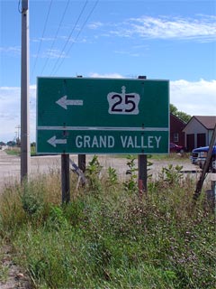
|
At Highway 24-North: NB: Turn
left onto Wellington Road 24 towards Grand Valley. SB: Turn right onto
Wellington Road 124 towards Guelph. |
| Town of Erin |
Brisbane |
--- (53.3km) / --- (44.7km) |
Highway 24-North (Wellington Road 124-North) &
Trafalgar Road (Wellington Road 24-South) |
| Town of Erin |
--- |
--- (59.4km) / --- (38.6km) |
Wellington Road 22 |
| Town of Erin |
Hillsburgh |
--- |
----- |
|
Wellington - Dufferin Boundary:
NB: North to Highway 9, Highway 25 is now known as Dufferin Road 24.
SB: Highway 25 is known as Wellington Road 24. |
| Wellington County - Dufferin County Boundary |
--- |
--- (65.5km) / --- (32.5km) |
----- |
| Township of East Garafaxa |
Reading |
--- (68.4km) / --- (29.6km) |
Dufferin Road 3 |
|
At Highway 9-East: NB: Turn
left and follow Dufferin Road 109 towards Grand Valley. SB: Turn right
on Dufferin Road 24 towards Acton. |
| East Garafaxa - Amaranth Boundary |
----- |
--- (75.5km) / --- (22.5km) |
Highway 9-East
(Dufferin Road 109-East) |
| East Garafaxa - East Luther Grand Valley
Boundary |
----- |
--- (75.9km) / --- (22.1km) |
10th Line (Formerly Dufferin Road 6) |
|
At Highway 9-West: NB: Turn
right onto Dufferin Road 25 towards Grand Valley. SB: Turn left
towards Orangeville. |
| East Garafaxa - East Luther Grand Valley
Boundary |
----- |
--- (78.3km) / --- (19.7km) |
Highway 9-West
(Dufferin Road 109-West) |
| Township of East Luther Grand Valley |
(Former) Grand Valley
South Limits |
--- (79.8km) / --- (18.1km) |
----- |
| Township of East Luther Grand Valley |
(Former) Grand Valley
North Limits |
--- (81.8km) / --- (16.2km) |
----- |
| Township of East Luther Grand Valley |
----- |
--- (83.8km) / --- (14.2km) |
Dufferin Road 10 |
| Township of East Luther Grand Valley |
Talbert |
--- |
----- |
| Township of East Luther Grand Valley |
----- |
--- (92.6km) / --- (5.4km) |
Dufferin Road 15 |
| Township of East Luther Grand Valley |
----- |
--- (98.0km) / --- (0km) |
King's Highway 89 |
|
Highway 25 ENDS |