Highway 11
Looking South from Highway 9 in Newmarket. Picture taken February 8th, 2004
(Toronto to Highway 93 just north of Barrie) - This chart represents the totally downloaded routing of Highway 11 from Toronto to Barrie. The last entry on this chart is the only active section of Highway left, which is a renumbered section of Highway 400A, used to connect Highway 11 to the 400
Communities and Major Intersections located along Highway 11 from Toronto to Barrie:
|
Proper Municipality Name |
Community Name |
Major Intersection |
|
|
The city of Toronto has for the most part left Highway 11 posted, it is now officially just known as Yonge Street |
|||
| City of Toronto | Toronto (downtown) | Lakeshore Boulevard & Gardiner Expressway (Highway 2) | |
| City of Toronto | Toronto (downtown) | Front Street | |
| City of Toronto | Toronto (downtown) | Wellington Street | |
| City of Toronto | Toronto (downtown) | Adelaide Street | |
| City of Toronto | Toronto (downtown) | Richmond Street | |
| City of Toronto | Toronto (downtown) | Queen Street | |
| City of Toronto | Toronto (downtown) | Dundas Street | |
| City of Toronto | Toronto (downtown) | Carleton Street | |
| City of Toronto | Toronto (downtown) | Bloor Street (Highway 5) | |
| City of Toronto | Toronto | Church Street & Davenport Road) | |
| City of Toronto | Toronto | St. Clair Avenue | |
| City of Toronto | Toronto | Eglinton Avenue | |
| City of Toronto | Toronto | Lawrence Avenue | |
| City of Toronto | North York | York Mills Road & Wilson Avenue | |
| City of Toronto | North York | King's Highway 401 | |
| City of Toronto | North York | Sheppard Avenue | |
| City of Toronto | North York | Finch Avenue | |
|
North of Steeles Highway 11 now belongs to York Region. They have named Highway 11 York Road 1 |
|||
| Toronto - York Region Boundary | North York - Thornhill | Steeles Avenue | |
| Markham - Vaughan Boundary | Thornhill | John Street | |
| Markham - Vaughan Boundary | Thornhill | Centre Street (At one time this was Highway 7B, downloaded in the 70's) | |
| Markham - Vaughan - Richmond Hill Boundary | Thornhill | Highway 407 ETR | |
| Town of Richmond Hill | Richmond Hill | Highway 7 (York Road 7, Highway 7) | |
| Town of Richmond Hill | Richmond Hill | York Road 73 (16th Avenue, Carrville Road) | |
| Town of Richmond Hill | Richmond Hill | Major MacKenzie Drive (York Road 25) | |
| Town of Richmond Hill | Richmond Hill | Elgin Mills Road (York Road 49) | |
| Town of Richmond Hill | Stouffville Road (York Road 14) | ||
| Town of Richmond Hill | Oak Ridges | King Road (York Road 11) | |
| Richmond Hill - Aurora Boundary | Oak Ridges | Bloomington Road (York Road 40) | |
| Town of Aurora | Aurora | Wellington Street (Aurora Road, York Road 15) | |
| Town of Newmarket | Newmarket | Mulock Road (York Road 74) | |
|
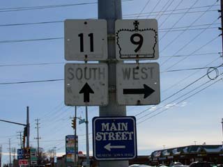
The only remaining junction squares left to denote the intersection of Highways 9 and 11. Picture taken February 8th, 2004 |
|||
| Town of Newmarket | Newmarket | Highway 9 (York Road 31, Highway 9) & Davis Drive (York Road 31) | |
| Town of East Gwillimbury | Newmarket | Green Lane (York Road 19) | |
| Town of East Gwillimbury | Yonge Street / Holland Landing Road (York Road 83) | ||
| Town of East Gwillimbury | Holland Landing (Bypass) | ||
| East Gwillimbury - King Boundary | Bathurst Street (York Road 38) | ||
|
The city of Bradford is not included in Simcoe County's road network, Highway 11s proper names are Bridge Street, Holland Street, and Barrie Road |
|||
| Bradford- West Gwillimbury | Bridge Street | Bradford | Canal Road (Simcoe Road 8) |
| Bradford- West Gwillimbury | Bridge Street - At Dissette Street Highway 11 curves left and becomes Holland Street |
Bradford |
|
|
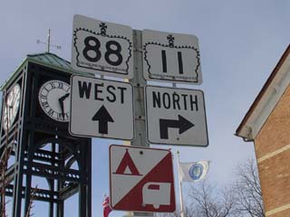
When heading north Highway 11 turns north at Barrie Road in Bradford, Highway 88 continues straight on. Picture taken February 8th, 2004 |
|||
| Bradford- West Gwillimbury | Holland Street (East) - Turn Right on Barrie Road to stay on 11 | Bradford | Highway 88 (Holland Street W) & Simcoe Road |
|
North of 8th Line Highway 11 is now known as Simcoe Road 4 |
|||
| Town of Bradford- West Gwillimbury | Coulson | ||
| Town of Bradford- West Gwillimbury | Deerhurst | ||
| Town of Innisfil | Fennel | Highway 89 (Simcoe Road 89) & Shore Acres Drive (Simcoe Road 3) | |
| Town of Innisfil | Churchill | ||
| Town of Innisfil | Barclay | Innisfil Beach Road (Simcoe Road 21) | |
| Town of Innisfil | Stround | ||
|
The City of Barrie (much like Bradford) maintains all its own roads, north of Mapleview Drive, Simcoe Road 4 ends, and Highway 11 is known once again as Yonge Street |
|||
| Innisfil - Barrie boundary | Yonge Street | St. Paul's (Bypass) | Mapleview Drive |
| City of Barrie | Yonge Street | Barrie | Big Bay Point Road |
| City of Barrie | Yonge Street | Barrie | Huronia Street |
| City of Barrie | Yonge Street - Turn Right onto Essa Road to stay on Highway 11. | Barrie | Essa Road (Prior to 1997 Highway 27_South). (Prior to 1997 Highway 27 was multiplexed along Highway 11 through Downtown Barrie) |
| City of Barrie | Essa Road - At Tiffin Road Essa Street curves to the left to become Bradford Road | Barrie | Tiffin Street (Highway 90 before the 400 opened) |
| City of Barrie | Bradford Road - Turn right on Dunlop Street to stay on 11. | Barrie | Highway 90 (Dunlop Street West) |
| City of Barrie | Dunlop Street | Barrie | Bayfield Road (Highway 26/27 SB). (SB Concurrent routing with Highway 27 ended in 1997) |
| City of Barrie | Dunlop Street | Barrie | Clapperton Street (Highway 26/27 NB). (NB Concurrent routing with Highway 27 ended in 1997). |
| City of Barrie | Dunlop Street - At Collier Street curve to the right 11 now follows Blake Street | Barrie | |
| City of Barrie | Blake Street | Barrie | Shanty Bay Road |
| City of Barrie | Blake Street - Curve Left and the road 11 follows Penetanguishene Road | Barrie | |
|
From Penatanguishene Road Northerly Highway 11 has been renumbered Simcoe Road 93 |
|||
| Township Of Oro-Medonte | Highway 400A (Since been renumbered as a small extension of Highway 11) & Highway 93 (Simcoe Road 93) | ||
|
After 1997 Highway 11 was rerouted to join with King's Highway 400 by assuming all of Highway 400A |
|||
| Township of Oro-Medonte | Simcoe Road 93 (Former Highway 11 & Former Highway 93) | ||
|
North of Simcoe Road 93 Highway 11 was not changed by provincial downloading. See Page 2 for the Continuation |
|||