King's Highway 11 - O N T H I G H W A Y S
Page 2 -
Crown Hill to Highway 17(West), North Bay
Highway 11 is for the most part
a 4-lane divided expressway between Crown Hill and North Bay. The small
sections that has not been twinned will likely be 4-laned in the next 5 -
6 years.
.jpg)
Picture taken February 29th, 2004
|
|
Highway 11 information that pertains to
the Crown Hill to North Bay section:
Multiplexes: 2.4 km with Highway 12 on the Orillia Bypass; 4.1 km
with Highway 17 on the North Bay bypass. Before downloading there was also
an 18.4 km multiplex with Highway 169.
Freeway: Highway 11 is a RIRO
type expressway from Crown Hill to Gravenhurst (with the exception of the
Orillia Bypass which is to full freeway standards). North of Highway 169
at Gravenhurst, Highway 11 is at times a full fledged freeway, and at other times
a four-lane expressway with limited grade crossings at minor side roads;
this is the case to Highway 518, north of Emsdale. Between Highway 518 and
South Creek Highway 11 is just a conventional 'two-lane' highway, though the MTO
is in the process of twinning this to make it of freeway/expressway grade in the
very near future. Between South Creek and Highway 17 (East JCT) Highway 11
is once again a mix of expressway and freeway standard.
AADT
(2001): Highest: 33 000 from Highway 93 (Simcoe Road 93) to Oro-Medonte
Road 4;
Lowest: 5 900 from Highway 520 to Ontario Street (hwy 7162) on the
Burk's Falls bypass.
Road Info: Highway 11 is in good shape
for this entire section. The RIRO section in the south can be quite
congested during the summer months, especially south of Orillia. There are
some newly twinned sections north of Huntsville that are just gorgeous, a true
pleasure to drive. The remainder of Highway 11 is properly maintained. |
Communities and Major Intersections / RIROs with turn around's
are shown in tables with 4 columns. Interchange and Control City
information is shown in tables with 5 columns:
|
Proper Municipality Name |
Community Name |
Distance* |
Intersecting Road / RIRO |
|
Proper Municipality Name |
Exit # |
Intersecting Road |
North / West Control
City |
South / East Control
City |
| Springwater - Oro- Medonte Boundary |
----- |
1.1 km (99.3 km) / |
Highway 93 / Formerly Highway
11 South (See page 1) |
| Township of Oro- Medonte |
----- |
Coming Soon! |
Oro - Medonte Line 3 |
| Township of Oro- Medonte |
----- |
|
Oro - Medonte Line 5 |
| Township of Oro- Medonte |
Guthrie |
|
(Oro - Medonte Line 6) |
| Township of Oro- Medonte |
----- |
|
Oro - Medonte Line 7 |
| Township of Oro- Medonte |
----- |
|
Oro - Medonte Line 9 |
| Township of Oro- Medonte |
----- |
|
Oro - Medonte Line 11 (Simcoe Road 20) |
| Township of Oro- Medonte |
----- |
|
Oro - Medonte Line 14 |
| Oro- Medonte - Orillia Boundary |
Orillia Bypass |
|
Oro - Medonte Line 15 & Memorial Ave (Formerly Highway 11B) |
|
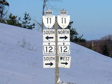
A nice example of
non-standard signage; looking from Old Barrie Road at the interchange of
Highway's 11&12. Picture taken February 4th, 2004 |
| City of Orillia |
Orillia Bypass |
|
King's Highway 12-South & Old Barrie Road (Simcoe Road 11) |
|

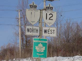
A very faded 11
sign on the 11/12 multiplex; this does however show a very nice Georgian Bay
Route Trans-Canada Highway Sign. Picture taken February 4th, 2004 |
| City of Orillia |
Orillia Bypass |
|
King's Highway 12-West & Coldwater Road (Formerly Highway
12B) |
| Orillia - Severn Boundary |
Orillia Bypass |
|
West Street |
| Orillia - Severn Boundary |
Orillia Bypass |
|
Lacile Street (Formerly Highway 11B) |
| Township of Severn |
----- |
|
Telford Line |
| Township of Severn |
----- |
|
Sparrow Lake Road & Goldstein Road |
| Township of Severn |
----- |
|
Agnew Road |
| Township of Severn |
----- |
|
Highway 169-South (Simcoe Road 169) |
| Township of Severn |
Severn Bridge |
|
Simcoe Road 52 & Canal Road |
| Town of Gravenhurst |
Severn Bridge |
|
Southwood Road (Muskoka Road 13) |
| Town of Gravenhurst |
----- |
|
Sparrow Lake Drive |
| Town of Gravenhurst |
----- |
|
Kilworthy Road & South Kanshe Lake Road |
| Town of Gravenhurst |
----- |
|
Sedore Road & Beaver Ridge Road |
|
At Highway 169 north jct (Dead
Man's Corner) the RIRO section ends, divided highway with both full
interchanges and median crossings starts northerly |
| Town of Gravenhurst |
169 |
Highway 169-North (Muskoka Road 169) |
Gravenhurst |
X X X X X |
| Town of Gravenhurst |
175 |
Bethune Drive (Muskoka Road 41) |
Gravenhurst |
----- |
| Gravenhurst - Bracebridge Boundary |
182 |
King's Highway 118 / Muskoka
Road 118 West |
Bracebridge |
|
| Town of Bracebridge |
184 |
Fredrick Street (Muskoka Road 37) |
|
|
| Town of Bracebridge |
189 |
Taylor Drive (Muskoka Road 42) |
Bracebridge |
|
| Town of Bracebridge |
193 |
Highway 117 (Muskoka Road 117) & Cedar Lane |
|
|
| Town of Huntsville |
At Grade Intersection |
South Mary Lake Road (Muskoka Road 44) |
|
|
| Town of Huntsville |
207 |
King's Highway 141 & Port Sydney Road (Muskoka Road 10) |
Rouseau, Parry Sound |
Port Sydney |
| Town of Huntsville |
219 |
Muskoka Road 3 |
|
Huntsville |
| Town of Huntsville |
221 |
Ravenscliffe Road (Muskoka Road 2) |
|
Huntsville |
| Town of Huntsville |
223 |
King's Highway 60 |
X X X X X |
Ottawa |
| Town of Huntsville |
226 |
Muskoka Road 3 |
|
|
| Town of Huntsville |
231 |
Rockhaven Road |
Melissa |
|
| Huntsville - Perry Boundary |
235 |
Secondary Highway 592 |
Novar |
|
| Township of Perry |
|
Rockcliffe Lane |
|
|
| Township of Perry |
|
Fern Glen Road & Scotia Road |
|
|
| Township of Perry |
|
Secondary Highway 518 |
|
|
|
Divided Highway ENDS |
| Township of Perry |
----- |
(Distance Coming Soon) |
Secondary Highway 592 |
| Township of Armour |
----- |
|
Secondary Highway 520 |
| Township of Armour |
----- |
|
Ontario Street (Highway 7162) |
| Township of Strong |
Stirling Falls |
|
----- |
| Township of Strong |
----- |
|
King's Highway 124 |
| Township of Strong |
Sundridge |
|
----- |
| Township of Machar |
South River |
|
Ottawa Avenue |
|
Divided Highway BEGINS Again |
|
Township of Laurier |
|
Goreville Road & Summit Road |
|
|
| Laurier - Powasson Boundary |
301 |
Secondary Highway 522 & McFadden Lane |
|
|
| Municipality of Powasson |
306 |
Secondary Highway 522B |
|
|
| Municipality of Powasson |
316 |
Secondary Highway 534 |
|
|
| Township of North Himsworth |
329 |
Secondary Highway 654 (To King's Highway 94) |
|
|
| City of North Bay |
336 |
Highway 11B (Lakeshore Drive) |
|
X X X X X |
| City of North Bay |
344 |
King's Highway 17-East |
X X X X X |
Ottawa |
|
Highway 17 marks the last exit of
the Highway 11 expressway to North Bay. 11/17 is a conventional city
street |
| City of North Bay |
North Bay |
(Distance Coming Soon) |
Highway 17B (Fisher Street) |
| City of North Bay |
North Bay |
|
Fisher Street |
| City of North Bay |
North Bay |
|
King's Highway 63 |
|
At Highway 17 West Junction:
NB: Turn Right towards Cochrane (Page
3), SB: Turn Left towards Barrie,
Toronto |
| City of North Bay |
North Bay |
|
King's Highway 17-West & Algonquin Avenue |
|
See Page 3 for
continuation |
Highway 11 (Page 2) - Images
Page 1 (Toronto to Crown Hill)
Page 3 (North Bay to Cochrane)
Highway 11 Home
O N T
H I G H W A Y S - Home
Copyright (c) 2004,2005 Scott Steeves (Webmaster)
webmaster@onthighways.com
Page last updated: January 17th, 2005
Page created: April 15th, 2004