|
Proper Municipality Name |
Community Name |
Distance |
Intersecting Road |
|
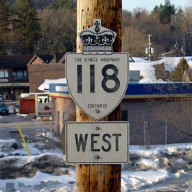
West of Highway 11, Highway 118
was downloaded and is now known as Muskoka Road 118 West |
| Township of Muskoka Lakes |
Glen Orhard |
0 km / 171.9 km |
Highway 169 (Muskoka Road 169) |
| Township of Muskoka Lakes |
----- |
5.3 km / 166.6 km |
Penninsula Road (Muskoka Road 7) |
| Township of Muskoka Lakes |
----- |
--- |
Muskoka Road 26 |
| Township of Muskoka Lakes |
----- |
--- |
Muskoka Road 27 |
| Township of Muskoka Lakes |
Port Carling |
--- |
|
| Township of Muskoka Lakes |
----- |
10.7 km / 161.2 km |
Falkenburg Road (Muskoka Road 47) |
| Township of Muskoka Lakes |
Valley Green Beach |
--- |
|
| Township of Muskoka Lakes |
Willow Beach |
--- |
|
| Township of Muskoka Lakes |
Cedar Village |
--- |
|
| Town of Bracebridge |
----- |
29.6 km / 142.3 km |
Golden Beach Road (Muskoka Road 15 |
|
Heading east to stay on Highway 118 you must turn right at
Wellington Street, WB traffic turns left onto Monck Road |
| Town of Bracebridge |
Bracebridge |
32.0 km / 139.9 km |
Monk Road & Wellington Street |
| Town of Bracebridge |
Bracebridge |
--- |
Santa's Village Road (Muskoka Road 15) |
| Town of Bracebridge |
Bracebridge |
--- |
Muskoka Road 16 (Beaumont Drive & Ecclestone Drive |
| Town of Bracebridge |
----- |
--- |
Muskoka Beach Road |
|
Provincial Control Begins about 1
km West of Highway 11 |
| Town of Bracebridge |
----- |
38.4 km / 133.5 km |
King's Highway 11 |
| Town of Bracebridge |
Muskoka Falls |
--- |
Airport Road (Muskoka Road 1) |
| Town of Bracebridge |
----- |
48.8 km / 123.1 km |
Uffington Road (Muskoka Road |
| Town of Bracebridge |
Clear Lake |
--- |
----- |
| Township of Anson Hindon Minden Lutterworth and Snowdon |
----- |
--- |
Kushong Lake Road (Halliburton Road 11) |
| Township of Anson Hindon Minden Lutterworth and Snowdon |
Carnarvon |
97.5 km / 74.4 km |
King's Highway 35 |
| Township of Algonquin Highlands |
Maple Leaf |
--- |
----- |
| Dysart, Dudley, Harcourt, Guilford, Halburn, Bruton,
Havelock, eyre and Clyde |
----- |
110.8 km / 61.1 km |
Eagle Lake Road (Haliburton Road 16) |
| Dysart, Dudley, Harcourt, Guilford, Halburn, Bruton,
Havelock, Eyre and Clyde |
----- |
116.7 km / 55.2 km |
Haliburton Lake Road (Haliburton Road 14) |
| Dysart, Dudley, Harcourt, Guilford, Halburn, Bruton,
Havelock, Eyre and Clyde |
----- |
--- |
Harburn Road (Haliburton Road 19) |
| Dysart, Dudley, Harcourt, Guilford, Halburn, Bruton,
Havelock, Eyre and Clyde |
Haliburton |
122.0 km / 49.9 km |
Highway 121 (Haliburton Road 21, Highland Street) |
|
Before Summer 2003 Highway 121
led traffic easterly out of Haliburton, that has since been renumbered to
Highway 118 |
| Dysart, Dudley, Harcourt, Guilford, Halburn, Bruton,
Havelock, Eyre and Clyde |
----- |
126.5 km / 45.4 km |
Buckhorn Road (Haliburton Road 3) |
| Municipality of Highlands East |
Essonville |
140.3 km / 31.6 km |
Essonville Road (Haliburton Road 4) |
| Municipality of Highlands East |
Tory Hill |
145.4 km / 26.5 km |
Highway 503 (Haliburton Road 503) |
| Municipality of Highlands East |
----- |
149.2 km / 22.7 km |
Highway 648 (Haliburton Road 648 |
| Municipality of Highlands East |
Cope Falls |
--- |
----- |
| Municipality of Highlands East |
------ |
158.9 km / 13.0 km |
Highway 648_South (Haliburton Road 648). (1.8 km
Concurrent routing with Highway 648 begins). |
| Municipality of Highlands East |
------ |
160.7 km / 11.2 km |
Highway 648_North (Haliburton Road 648). Concurrent
Routing with 648 ENDS). |
| Municipality of Highlands East |
------ |
--- |
McGillivary Road (Haliburton Road 9) & Monck Road) |
| Township of Faraday |
Paudash |
171.9 km / 0km |
King's Highway 28 |
|
Highway 118 ENDS |