AsphaltPlanet.ca >
OntHighways > Highway 121 > Images
< Hwy 118
Hwy 124 >
King's Highway 121 - www.OntHighways.com
Highway 121 was primarily a local highway
before it was decommissioned and re-designated. The highway had two two distinct segments: The southern segment was a highway that ran parallel to
Highway 35 between Powles Corners south of Fenelon Falls, and Minden.
Highway 121 is just over three kilometers longer than Highway 35 between Powles
Corners and Minden, though Highway 121 serves more local traffic, as passes
through Fenelon Falls (a large town by Kawartha Lakes' standpoint that nearly doubles in population during the summer
months), and Kinmount. Highway 121 rejoined Highway 35 south of Minden, the
two routes ran concurrently with one-another through Minden along a four-lane
arterial highway. North of Minden, Highway 121 split from Highway 35 bound
northeasterly for Haliburton Village. It is at this junction that Highway
121 ceased to run parallel to Highway 35, and is the transition between Highway
121 the north south highway and Highway 121 the east-west highway. East
of Haliburton, Highway 121 ran through a near deserted portion of the Haliburton
Highlands. The highway intersected with Highway, 503, Highway 648 (three
times, sharing a short concurrency with this convoluted route), before
terminating at Highway 28 southwest of Bancroft. Highway 121 was
downloaded south of Haliburton Village to the counties of Victoria (now the City
of Kawartha Lakes) and Haliburton, while the highway remained in the provincial
highway network. Between 1998, and 2003 Highway 121 shared a common
terminus with Highway 118 in Haliburton Village. Since, both Highway 118
and Highway 121 were east-west highways, a decision was made to re-designate the
remaining east-west leg of Highway 121 as Highway 118. Signs were changed
from Highway 121 to Highway 118 during the Spring of 2003. This decision
greatly improved the route numbering scheme within Haliburton County, and
eradicated the remaining piece of the King's Highway 121 from the MTO's log
books.
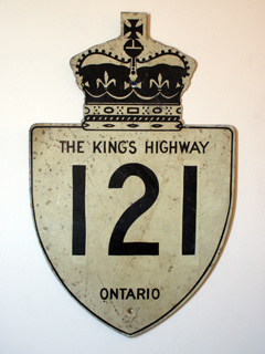
King's Highway 121 Shield
|
|
Southern
Terminus: Junction Highway 35 at Powles Corners.
Eastern Terminus: Junction Highway
28 southeast of Bancroft.
Length:
133.7km
Multiplexes: 4.5km with Highway
35 through Minden
Freeway: No
AADT (1994):
Highest: 6,800, from Fenelon Falls northerly to to Victoria Road 8;
Lowest: 800, from east junction of Highway 648 easterly to Bicroft.
Status: Entirely re-designated:
South of Highway 118, Highway 121 is Kawartha Lakes Road 121, Haliburton
Road 121, King's Highway 35, and Haliburton Road 21. The eastern leg
of Highway 121 has been incorporated into Highway 118's routing.
Road Info: Admittedly it has been
several years since I have travelled any section of Highway 121 as I write
this. From what I recall, Highway 121 is generally in fair condition
through Kawartha Lakes. Kawartha Lakes does not maintain its county
road network well, and while the surface condition of the highway is good,
travelers should expect very poor lane markings and road signage.
Things improve in Haliburton, as while Haliburton County does not
have the means to maintain a road to the same standards as the province
does, they have done a good job with the upkeep of Highway 121. The
section of Highway 121 that is now Highway 118 is of course well maintained
as it is still a provincial highway, though some sections have not been
surfaced in quite sometime. Highway 121 has a rural speed limit of
80km/h. |
Communities and Major Intersections located along Highway 121 from South to
North to East:
|
Proper Municipality Name |
Community Name |
Distance |
Intersecting Road |
|
The City of
Kawartha Lakes has designated the former Highway 121 as Kawartha Lakes Road
121 |
| City of Kawartha Lakes |
Powles Corners |
0km / 133.7km |
King's Highway 35
(South Junction) |
| City of Kawartha Lakes |
Fenelon Falls West Limits |
5.6km / 128.1km |
----- |
| City of Kawartha Lakes |
Fenelon Falls |
6.3km / 127.4km |
Highway 35A (Kawartha Lakes Road 8-West) |
| City of Kawartha Lakes |
Fenelon Falls |
6.6km / 127.1km |
Francis Street (Kawartha Lakes Road 22) |
| City of Kawartha Lakes |
Fenelon Falls East Limits |
7.4km / 126.3km |
----- |
| City of Kawartha Lakes |
----- |
8.0km / 125.7km |
Kawartha Lakes Road 8-East |
| City of Kawartha Lakes |
----- |
15.1km / 118.6km |
Kawartha Lakes Road 36 |
| City of Kawartha Lakes |
----- |
30.7km / 103.0km |
Highway 649 (Kawartha Lakes Road 649) |
| City of Kawartha Lakes |
Kinmount |
40.4km / 93.3km |
Highway 503-East (Kawartha Lakes Road 503-East) |
| City of Kawartha Lakes |
Kinmount |
40.6km / 93.1km |
Highway 503-West
(Kawartha Lakes Road 503-West) |
| Kawartha Lakes (Victoria) / Haliburton Boundary |
----- |
44.9km / 88.8km |
----- |
| Township of Minden Hills |
----- |
48.1km / 85.6km |
Haliburton Road 1-West |
|
At Highway 35-South: NB: Follow the ramp towards Minden. SB:
Turn Left at the top of the hill towards Kinmount and Bobcaygeon. |
| Township of Minden Hills |
----- |
56.2km / 77.5km |
King's Highway 35-South |
| Township of Minden Hills |
----- |
58.6km / 75.1km |
Haliburton Road 16 |
|
At Highway 35-North: NB: Follow the ramp to Haliburton Road 21-North
to Haliburton. SB: Turn Left at the stop-sign bound towards Minden. |
| Township of Minden Hills |
----- |
60.7km / 73.0km |
King's Highway 35-North |
| Township of Minden Hills |
----- |
68.1km / 65.6km |
Ingoldsby Road (Haliburton Road 18) |
| Township of Highlands East |
------ |
82.8km / 50.9km |
Haliburton Road 1-East |
|
At Haliburton: NB: Turn Right at traffic signal following Highway
118-East. WB: Turn Left at traffic signal onto County Road 21 to
Minden. |
| Township of Highlands East |
Haliburton |
83.8km / 49.9km |
King's Highway 118 |
| Township of Highlands East |
----- |
88.3km / 45.4km |
Haliburton Road 3 |
| Township of Highlands East |
Essonville |
102.1km / 31.6km |
Haliburon Road 4 |
|
At Tory Hill: EB: Turn Left at stop sign towards Bancroft. WB:
Turn Right on Highway 118 towards Haliburton. |
| Township of Highlands East |
Tory Hill |
107.2km / 26.5km |
Highway 503 (Haliburton Road 503,
Furnace Falls Road) |
|
At Highway 648: EB: Turn Right towards Bancroft. WB: Turn Left
at the stop sign towards Haliburton. |
| Township of Highlands East |
----- |
111.0km / 22.7km |
Highway
648-West (Haliburton Road 648) |
| Township of Highlands East |
----- |
120.7km / 13.0km |
Highway 648-South (Haliburton Road 48) |
| Township of Highlands East |
----- |
122.5km / 11.2km |
Highway
648-East (Haliburton Road 648) |
| Township of Highlands East |
----- |
128.9km / 4.8km |
Haliburton Road 9 |
| Haliburton / Hastings Boundary |
----- |
129.9km / 3.8km |
----- |
| Township of Faraday |
Paudash |
133.7km / 0km |
King's Highway 28 |
|
King's Highway 121 Ends |
<-
Highway 118
www.OntHighways.com - Home
Highway 124 ->
Copyright (c) 2004-2010, AsphaltPlanet.ca
AsphaltPlanet@asphaltplanet.ca
Page last updated: June 8th, 2010
Page created: November 16th, 2004