|
Proper Municipality Name |
Community Name |
Distance |
Intersecting Road |
|
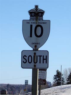
Highway 10 was downloaded in the cities of Brampton
and Mississauga, as it was a connecting link it now just known as Hurontario
Street (as it was before 1998 anyways) |
| City of Mississauga |
Port Credit |
0 km / 166.3 km |
Highway 2 (Lakeshore Road) |
| City of Mississauga |
Port Credit |
2.1 km / 164.2 km |
Queen Elizabeth Way (QEW) |
| City of Mississauga |
Cooksville |
--- |
Queensway (Peel Road 20) |
| City of Mississauga |
Cooksville |
--- |
Highway 5 (Dundas Street) |
| City of Mississauga |
Square One |
--- |
Burnhamthorpe Drive |
| City of Mississauga |
Square One |
7.1 km / 159.2 km |
King's Highway 403 |
| City of Mississauga |
Mississauga |
--- |
Eglinton Avenue |
| City of Mississauga |
Mississauga |
--- |
Brittania Road (Peel Road 3) |
| City of Mississauga |
Mississauga |
11.9 km / 158.5 km |
King's Highway 401
(Autoroute M-C Freeway) |
| City of Mississauga |
Derry West |
14.5 km / 153.7 km |
Derry Road (Peel Road 5) |
| City of Brampton |
----- |
16.3 km / 151.9 km |
Highway 407 ETR |
| City of Brampton |
Brampton |
17.5 km / 145.7 km |
Steeles Avenue (Peel Road 15) |
| City of Brampton |
Brampton |
--- |
Queen Street |
| City of Brampton |
Brampton |
--- |
Williams Parkway |
| City of Brampton |
Brampton |
23.7 km / 144.5 km |
Highway 7 (Bovaird Drive, Peel Road 107) |
| City of Brampton |
Brampton |
--- |
Sandalwood Parkway |
| City of Brampton |
Snelgrove |
28.0 km / 138.3 km |
Mayfield Road (Peel Road 14) |
|
Provincially control over Highway
10 begins northerly at the Brampton / Caledon Boundary (at the precise point
where the future 410 will join with Highway 10) |
| Town of Caledon |
Valleywood |
--- |
----- |
| Town of Caledon |
Victoria |
34.2 km / 132.1 km |
King Street (Peel Road 9) |
| Town of Caledon |
Claude |
--- |
----- |
| Town of Caledon |
----- |
38.5 km / 127.8 km |
Olde Baseline Road (Peel Road 12) |
| Town of Caledon |
----- |
43.5 km / 122.8 km |
Forks of the Credit Road (Peel Road 11) |
| Town of Caledon |
Caledon |
47.9 km / 118.4 km |
Charleston Sideroad (Peel Road 24) *Formerly*
Highway 24_South. |
| Town of Caledon |
McLeodville |
--- |
----- |
| Town of Orangeville |
Orangeville |
57.2 km / 109.1 km |
King's Highway 9_East. |
| Town of Orangeville |
Orangeville |
57.8 km / 108.5 km |
Highway 9_West
(Broadway). |
| Town of Orangeville |
Orangeville |
--- |
First Street |
| Town of Mono |
Biggles |
61.0 km / 105.3 km |
Dufferin Road 16 & Hockley Road (Dufferin Road 7) |
| Town of Mono |
----- |
--- |
10th Sideroad (Dufferin Road 10) |
| Town of Mono |
Camilla |
--- |
Mono Centre Road (Dufferin Road 8) |
| Town of Mono |
----- |
70.3 km / 96.0 km |
(20th Sideroad) |
| Town of Mono |
Elba |
--- |
----- |
|
In Primrose: NB: Turn Left at Highway
89. SB: Ramp to the right towards Orangeville |
| Mono - Mulmer Boundary |
Primrose |
77.3 km / 89.0 km |
King's Highway 89_East & Dufferin Road 19) |
| Shelburne - Melancthon - Amaranth Boundary |
Shelburne |
81.3 km / 85.0 km |
Highway 24_North
(Dufferin Road 124). |
|
At the Traffic Lights in Downtown
Shelburne NB: Turn Right towards Owen Sound. SB: Turn Left towards Orangeville |
| Town of Shelburne |
Shelburne |
83.1 km / 83.2 km |
King's Highway 89_West
& Dufferin Road 11. |
| Township of Melancthon |
Melancthon |
89.7 km / 76.6 km |
Dufferin Road 17 |
| Township of Melancthon |
Corbetton |
95.8 km / 70.5 km |
Dufferin Road 21 |
| Southgate - Melancthon Boundary |
Dundalk |
101.8 km / 64.5 km |
Dufferin Road 9 & Grey Road 9 |
| Southgate - Grey Highlands Bounary |
----- |
110.2 km / 56.1 km |
Road 190 (Formerly Grey Road 34) |
| Municipality of Grey Highlands |
Flersherton |
118.5 km / 47.8 km |
Highway 4 (Grey Road 4) |
| Municipality of Grey Highlands |
---- |
--- |
Grey Road 32 |
| Grey Highlands - West Grey Boundary |
Markdale |
128.2 km / 38.1 km |
Grey Road 12 |
| Township of Chatsworth |
Mount Pleasant |
--- |
----- |
| Township of Chatsworth |
Berkeley |
--- |
----- |
| Township of Chatsworth |
Holland Centre |
143.0 km / 23.3 km |
Grey Road 24 |
| Township of Chatsworth |
Arnott |
--- |
----- |
| Township of Chatsworth |
----- |
151.5 km / 14.8 km |
Grey Road 40 |
|
In Chatsworth: NB: Take the Ramp on the
right towards Owen Sound. SB: In Downtown Chatsworth turn left
towards Shelburne |
| Township of Chatsworth |
Chatsworth |
153.8 km / 12.5 km |
King's Highway 6-South |
| Georgian Bluffs - Meaford Boundary |
Rockford |
161.5 km / 4.8 km |
Grey Road 18 (Alternate Route to Hwy 6, Formerly
Hwy 70) |
| City of Owen Sound |
Owen Sound |
--- |
6th Street E |
| City of Owen Sound |
Owen Sound |
--- |
8th Street E |
| City of Owen Sound |
Owen Sound |
166.3 km / 0 km |
King's Highway 6_North &
King's Highway 21 & King's Highway 26 |
|
Highway 10 ENDS |