|
|
|
|
|
|
South-
Bound
|
|
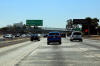
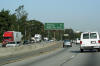
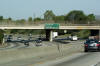
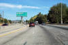
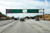
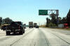
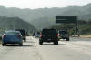
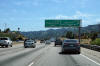
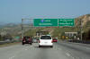
The San Gabriel River Freeway is Interstate 605.
Interstate 605 carries traffic north and south from Interstate 5 between
Seal Beach and Duarte.
Click here for Interstate 605 Images. |
|
Los Angeles County
City of Los Angeles
|
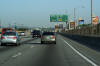
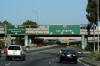
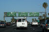
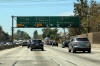
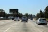
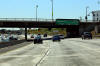
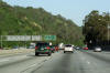
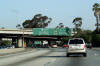
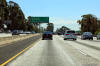
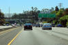
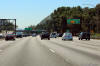
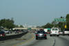
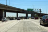
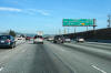
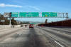
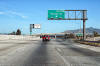
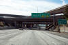
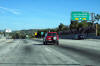
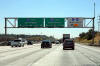
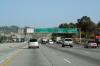
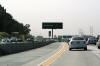
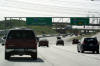
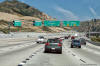
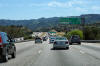
Next exit signage for Atlantic Boulevard and and
the Long Beach Freeway (I-710) along Interstate 5 North. |
 |
|
Photographed by: AsphaltPlanet.ca |
Date: 3/27/2010 |
High-res
|
|
Los Angeles County
City of Los Angeles
|
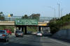
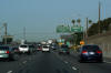
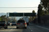
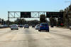
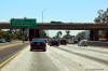
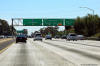
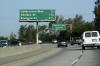
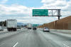
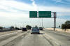
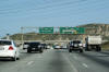
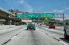
Standalone advanced signage for Atlantic Boulevard
South (which also leads to Interstate 710 South since there is no
direct connection from I-5). I find this signage
interesting, as not only does it lack the distance to the exit, but it is so heavily dependant upon
text. |
 |
|
Photographed by: AsphaltPlanet.ca |
Date: 3/27/2010 |
High-res
|
|
Los Angeles County
City of Los Angeles
|
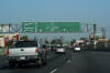
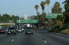
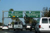
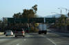
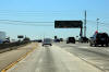
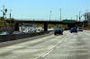
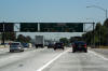
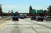
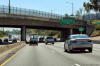
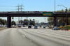
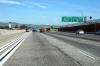
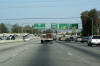
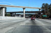
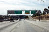
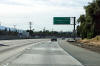
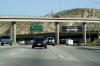
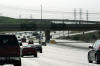
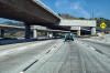
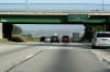
Overhead signage in advance of the Long Beach
Freeway interchange. The ramp to I-710 departs from the left hand
side of the carriageway. Only I-710 north is accessible from
I-5. Access to I-710 South is provided via surface streets and not
a direct freeway to freeway ramp. |
 |
|
Photographed by: AsphaltPlanet.ca |
Date: 3/27/2010 |
High-res |
|
Los Angeles County
City of Los Angeles
|
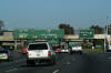
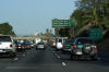
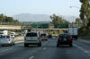
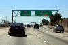
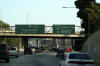
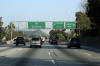
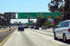
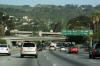
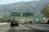
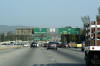
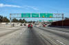
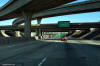
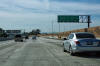
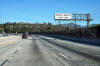
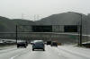
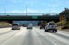
The northbound exit to Eastern Avenue is signed
with an advance sign for the Long Beach Freeway interchange. |
 |
|
Photographed by: AsphaltPlanet.ca |
Date: 3/27/2010 |
High-res:
(1440x960)
(2400x1600) |
|
Los Angeles County
City of Los Angeles
|
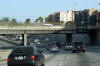
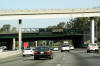
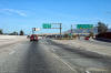
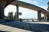
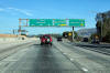
Overhead signage for the ramp to the 710 Freeway
North. As was mentioned in a caption above, the ramp to the 710 Freeway departs from the 5 from the
left side of the carriageway. The interchange was likely built this way to
minimize conflicts between surrounding closely spaced interchange ramps.
While I can certainly appreciate the logic of separating exit ramps from
entry ramps to minimize weaving,
from a driver's perspective it can be disorienting making what would be
a right turn on surface streets from the left side of the roadway.
Left lane entrances and exits were far more common of early highway
designs then they are of more modern highway designs. |
 |
|
Photographed by: AsphaltPlanet.ca |
Date: 3/27/2010 |
High-res
|
|
Los Angeles County
City of Los Angeles
|
Signage for the Indiana Street interchange. |
 |
|
Photographed by: AsphaltPlanet.ca |
Date: 3/27/2010 |
High-res
|
|
Los Angeles County
City of Los Angeles
|
Overhead signage in advance of the ramp to Grand
Vista Avenue situated in front of the advanced signage for the East Los
Angeles Interchange. Notice that the signs are laid out in
such a way that they indicate Interstate 5 as an
exit from US-101. US-101 begins its trek northerly
to Washington State at the left hand side of this upcoming interchange. |
 |
|
Photographed by: AsphaltPlanet.ca |
Date: 3/27/2010 |
High-res:
(1440x960)
(2400x1600) |
|
Los Angeles County
City of Los Angeles
|
Northbound next exit signage for Grand Vista
Avenue and the East Los Angeles Interchange. US-101 takes over the
Santa Ana Freeway designation from Interstate 5 north of the East LA
Interchange. I-5 becomes the Golden State Freeway northerly. |
 |
|
Photographed by: AsphaltPlanet.ca |
Date: 3/27/2010 |
High-res:
(1440x960)
(2400x1600) |
|
Los Angeles County
City of Los Angeles
|
Decisions, decisions... Overhead lane
assignment signage overtop of the US-101 split. The ramp to the
Santa Monica Freeway departs a few hundred meters beyond the ramp to
US-101 as outlined in the photos below. |
 |
|
Photographed by: AsphaltPlanet.ca |
Date: 3/27/2010 |
High-res:
(1440x960)
(2400x1600)
|
|
The Santa Ana Freeway becomes US-101.
US-101 departs Highway 14 carries traffic northeasterly from Interstate 5 through to
Lancaster, and Mojave and beyond.
Click here for US-101 Images. |
|
Los Angeles County
City of Los Angeles
|
Signage at the ramp that divides northbound I-5
traffic from traffic bound westbound on the Santa Monica Freeway. |
 |
|
Photographed by: AsphaltPlanet.ca |
Date: 3/27/2010 |
High-res:
(1440x960)
(2400x1600)
|
|
The Santa Monica Freeway is Interstate 10.
Highway 14 carries traffic northeasterly from Interstate 5 through to
Lancaster, and Mojave and beyond.
Click here for Interstate 10-West Images. |
|
Los Angeles County
City of Los Angeles
|
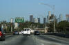
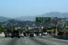
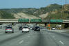
An outstanding view of the Downtown skyline greets
drivers as they approach the Seventh Street interchange. |
 |
|
Photographed by: AsphaltPlanet.ca |
Date: 3/27/2010 |
High-res:
(1440x960)
(2400x1600) |
|
Los Angeles County
City of Los Angeles
|
Southbound signage at the off-ramp to the Santa Monica Freeway. |
 |
|
Photographed by: AsphaltPlanet.ca |
Date: 3/27/2010 |
High-res:
(1440x960)
(2400x1600) |
|
Los Angeles County
City of Los Angeles
|
Southbound advanced lane assignment signage for the interchange with the
Santa Monica Freeway. |
 |
|
Photographed by: AsphaltPlanet.ca |
Date: 3/27/2010 |
High-res:
(1440x960)
(2400x1600) |
|
Los Angeles County
City of Los Angeles
|
Advanced signage for the San Bernardino Freeway
interchange. I find it interesting that Highway 10 is noted as the
San Bernardino Freeway, yet I-5 is not shown as the Golden State
Freeway. |
 |
|
Photographed by: AsphaltPlanet.ca |
Date: 3/27/2010 |
High-res
|
|
Los Angeles County
City of Los Angeles
|
Overhead signage at the Cesar Chavez Avenue
interchange. Interstate 10 is multiplexed along Route 5 between
the Santa Monica and San Bernardino Freeway's. |
 |
|
Photographed by: AsphaltPlanet.ca |
Date: 3/27/2010 |
High-res:
(1440x960)
(2400x1600)
|
|
Los Angeles County
City of Los Angeles
|
Overhead signage at the ramp to the San Bernardino
Freeway. Interestingly, the San Bernardino Freeway actually begins
just west of I-5 at the US-101 (Santa Ana) Freeway. Because I-10
follows I-5 northerly between the East Los Angeles Interchange and this
interchange, the westernmost kilometre or so of the San Bernardino
Freeway is actually an unnumbered highway. If this explanation is
confusing, I have included a
link to
handy map to illustrate the situation (map provided by Google Maps). |
 |
|
Photographed by: AsphaltPlanet.ca |
Date: 3/27/2010 |
High-res:
(1440x960)
(2400x1600) |
|
The San Bernardino Freeway is Interstate 10.
The San Bernardino Freeway carries traffic easterly across the Southern
United States as far as Jacksonville Florida.
Click here for Interstate 10-East Images. |
|
Los Angeles County
City of Los Angeles
|
Interchange sequence signage for the Fourth Avenue interchange located
within the footprint of the San Bernardino interchange. |
 |
|
Photographed by: AsphaltPlanet.ca |
Date: 3/27/2010 |
High-res:
(1440x960)
(2400x1600) |
|
Los Angeles County
City of Los Angeles
|
Overhead guide signage for the ramp from I-5 South
to the Pasadena Freeway. The overhead signage is somewhat
misleading, as the ramp to the Pasadena Freeway North doesn't actually
depart from the mainline interstate at this point. The ramp to the
Northbound Pasadena Freeway departs I-5 about 500m downstream. |
 |
|
Photographed by: AsphaltPlanet.ca |
Date: 3/27/2010 |
High-res:
(1440x960)
(2400x1600) |
|
Los Angeles County
City of Los Angeles
|
Signage at the southbound off-ramp to Mission Road. |
 |
|
Photographed by: AsphaltPlanet.ca |
Date: 3/27/2010 |
High-res:
(1440x960)
(2400x1600) |
|
Los Angeles County
City of Los Angeles
|
Southbound advanced overhead lane assignment signage for the ramp to
I-10 East. |
 |
|
Photographed by: AsphaltPlanet.ca |
Date: 3/27/2010 |
High-res:
(1440x960)
(2400x1600) |
|
Los Angeles County
City of Los Angeles
|
Interchange sequence signage facing southbound motorists in advance of
the Mission Road interchange. |
 |
|
Photographed by: AsphaltPlanet.ca |
Date: 3/27/2010 |
High-res:
(1440x960)
(2400x1600) |
|
Los Angeles County
City of Los Angeles
|
Next exit signage just north of the San Bernardino
Freeway interchange. Freeway's come quickly in LA. The
Pasadena Freeway interchange is found just over one mile north of the San
Bernardino Freeway interchange. |
 |
|
Photographed by: AsphaltPlanet.ca |
Date: 3/27/2010 |
High-res |
|
Los Angeles County
City of Los Angeles
|
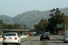
Advanced signage for the Main Street interchange.
The area to the north and east of Downtown L.A. is far more mountainous
than the flat lands to the south. |
 |
|
Photographed by: AsphaltPlanet.ca |
Date: 3/27/2010 |
High-res
|
|
Los Angeles County
City of Los Angeles
|
Two lane exit ramp to Broadway. |
 |
|
Photographed by: AsphaltPlanet.ca |
Date: 3/27/2010 |
High-res |
|
Los Angeles County
City of Los Angeles
|
Southbound signage at the off-ramp to Main Street.
This southbound signage is affixed to the Broadway overpass. |
 |
|
High-res:
(1440x960)
(2400x1600) |
 |
|
Photographed by: AsphaltPlanet.ca |
Date: 3/27/2010 |
High-res:
(1440x960)
(2400x1600) |
|
Los Angeles County
City of Los Angeles
|
Overhead sign for the ramp to the Pasadena Freeway
North. There is no ramp to the Pasadena Freeway South from I-5.
Traffic bound south on the 110 (the Pasadena and Harbour Freeway's) would
have logically opted to use the Santa Monica or Santa Ana Freeways to
access the 110. |
 |
|
Photographed by: AsphaltPlanet.ca |
Date: 3/27/2010 |
High-res:
(1440x960)
(2400x1600)
|
|
Los Angeles County
City of Los Angeles
|
The ramp to Figueroa Street departs from the ramp
to the Pasadena Freeway. The Pasadena Freeway utilizes a historic
alignment of Figueroa Street where the freeway passes beneath Elysian
Park. |
 |
|
Photographed by: AsphaltPlanet.ca |
Date: 3/27/2010 |
High-res |
|
Los Angeles County
City of Los Angeles
|
Northbound next exit signage just past the
Pasadena Freeway interchange. As is amazingly normal of L.A., the next freeway
interchange along I-5 is found just over
a mile north of the Pasadena Freeway. the Glendale Freeway is the
second exit to the north. |
 |
|
Photographed by: AsphaltPlanet.ca |
Date: 3/27/2010 |
High-res:
(1440x960)
(2400x1600) |
|
Los Angeles County
City of Los Angeles
|
Overhead guide signage for the ramp from I-5 South
to the Pasadena Freeway. The overhead signage is somewhat
misleading, as the ramp to the Pasadena Freeway North doesn't actually
depart from the mainline interstate at this point. The ramp to the
Northbound Pasadena Freeway departs I-5 about 500m downstream. |
 |
|
Photographed by: AsphaltPlanet.ca |
Date: 3/27/2010 |
High-res:
(1440x960)
(2400x1600) |
|
Los Angeles County
City of Los Angeles
|
Overhead signage for the ramp to Stadium Way.
As the street name suggests, Stadium Way carries traffic from the
Interstate to Dodger Stadium in Chavez Ravine. Adjacent to Dodger
Stadium is Elysian Park, which is one of Los Angeles' largest urban
parks. |
 |
|
Photographed by: AsphaltPlanet.ca |
Date: 3/27/2010 |
High-res:
(1440x960)
(2400x1600)
|
|
Los Angeles County
City of Los Angeles
|
Advanced overhead signage for the Glendale
Freeway. The Glendale Freeway is California Highway 2. |
 |
|
Photographed by: AsphaltPlanet.ca |
Date: 3/27/2010 |
High-res:
(1440x960)
(2400x1600) |
|
Los Angeles County
City of Los Angeles
|
Overhead sign overtop of the ramp to Highway 2
South. While Highway 2 continues all the way to Santa Monica, the
Glendale Freeway does not. In fact the Glendale Freeway pretty
well peters out immediately to the south of I-5. |
 |
|
Photographed by: AsphaltPlanet.ca |
Date: 3/27/2010 |
High-res:
(1440x960)
(2400x1600)
|
|
Route 2 is the Glendale Freeway through eastern Los
Angeles County.
Click here for Route 2 Images. |
|
Los Angeles County
City of Los Angeles
|
Southbound interchange sequence signage situated within the footprint of
the Glendale Freeway interchange. |
 |
|
Photographed by: AsphaltPlanet.ca |
Date: 4/16/2017 |
High-res:
(1440x960)
(2400x1600) |
|
Los Angeles County
City of Los Angeles
|
Overhead guide signage for the ramp from I-5 South
to the Pasadena Freeway. The overhead signage is somewhat
misleading, as the ramp to the Pasadena Freeway North doesn't actually
depart from the mainline interstate at this point. The ramp to the
Northbound Pasadena Freeway departs I-5 about 500m downstream. |
 |
|
Photographed by: AsphaltPlanet.ca |
Date: 4/16/2017 |
High-res:
(1440x960)
(2400x1600) |
|
Los Angeles County
City of Los Angeles
|
Southbound signage at the off-ramp to the Glendale Freeway. |
 |
|
Photographed by: AsphaltPlanet.ca |
Date: 4/16/2017 |
High-res:
(1440x960)
(2400x1600) |
|
Los Angeles County
City of Los Angeles
|
Southbound interchange sequence signage approaching the Glendale Freeway
interchange. |
 |
|
Photographed by: AsphaltPlanet.ca |
Date: 4/16/2017 |
High-res:
(1440x960)
(2400x1600) |
|
Los Angeles County
City of Los Angeles
|
Southbound view at the off-ramp to Fletcher Drive. |
 |
|
Photographed by: AsphaltPlanet.ca |
Date: 4/16/2017 |
High-res:
(1440x960)
(2400x1600) |
|
Los Angeles County
City of Los Angeles
|
Southbound signage in advance of the Fletcher Drive interchange. |
 |
|
Photographed by: AsphaltPlanet.ca |
Date: 4/16/2017 |
High-res:
(1440x960)
(2400x1600) |
|
Los Angeles County
City of Los Angeles
|
Guide signage for the Glendale Boulevard
Interchange. Take notice of the Hyperion Avenue overpass that is visible
in the distance behind the Glendale Boulevard overpass; it is an open
spandrel concrete arch bridge. Arch bridges such as this were
commonly constructed during the 1920s or early 1930s. This particular structure
likely pre-dates the interstate and first carried Hyperion Avenue across
the valley that the Five Freeway was constructed in. |
 |
|
Photographed by: AsphaltPlanet.ca |
Date: 3/27/2010 |
High-res:
(1440x960)
(2400x1600) |
|
Los Angeles County
City of Los Angeles
|
Signage at the southbound off-ramp to Glendale Boulevard. Note
that the next exit signage is for the Glendale Freeway, and not for
Fletcher Drive, which is in fact the next interchange along I-5 South.
Presumably this interchange was signed this way to ensure motorists do
not confuse Glendale Boulevard with the Glendale Freeway located a short
distance to the south. |
 |
|
Photographed by: AsphaltPlanet.ca |
Date: 4/16/2017 |
High-res:
(1440x960)
(2400x1600) |
|
Los Angeles County
City of Los Angeles
|
Overhead signage at the Colorado Street
interchange. A short connector road links Colorado Street to the
Five Freeway. Colorado Street is one of the principal east-west
roads within Eastern Los Angeles County. Further east, sections of
Colorado Street make up Historic Route 66. |
 |
|
Photographed by: AsphaltPlanet.ca |
Date: 3/27/2010 |
High-res |
|
Los Angeles County
City of Los Angeles
|
Southbound signage at the off-ramp to Los Feliz Boulevard. |
 |
|
Photographed by: AsphaltPlanet.ca |
Date: 4/16/2017 |
High-res:
(1440x960)
(2400x1600) |
|
Los Angeles County
City of Los Angeles
|
Southbound interchange sequence signage situated just south of the
off-ramp to Colorado Street. |
 |
|
Photographed by: AsphaltPlanet.ca |
Date: 4/16/2017 |
High-res:
(1440x960)
(2400x1600) |
|
Los Angeles County
City of Los Angeles
|
Southbound signage at the off-ramp to Colorado Street. |
 |
|
Photographed by: AsphaltPlanet.ca |
Date: 4/16/2017 |
High-res:
(1440x960)
(2400x1600) |
|
Los Angeles County
City of Los Angeles
|
Southbound advanced signage for the off-ramp to Colorado Street. |
 |
|
Photographed by: AsphaltPlanet.ca |
Date: 4/16/2017 |
High-res:
(1440x960)
(2400x1600) |
|
Los Angeles County
City of Los Angeles
|
Slightly blurry advanced exit sign for the Ventura
Freeway interchange. The Ventura Freeway is a long road that links
Ventura, northwest of Los Angeles, to Pasadena to the northeast of Los
Angeles. |
 |
|
Photographed by: AsphaltPlanet.ca |
Date: 3/27/2010 |
High-res
|
|
Los Angeles County
City of Los Angeles
|
Signage at the ramp to the Ventura Freeway West
from Interstate 5 North. Note that the signage to Ventura Freeway
does not indicate that this ramp leads westerly. While most L.A.
area freeways now show cardinal directions on highway signage, it is very
obvious that most of this signage has been retrofitted to show the
direction. This sign could be very misleading to a driver who is
unsure exactly where the City of Ventura is. |
 |
|
Photographed by: AsphaltPlanet.ca |
Date: 3/27/2010 |
High-res
|
|
Los Angeles County
City of Los Angeles
|
Next exit signage after the Ventura Freeway
interchange. |
 |
|
Photographed by: AsphaltPlanet.ca |
Date: 3/27/2010 |
High-res:
(1440x960)
(2400x1600) |
|
Los Angeles County
City of Los Angeles
|
Partial overhead sign for Scott Road. |
 |
|
Photographed by: AsphaltPlanet.ca |
Date: 3/27/2010 |
High-res:
(1440x960)
(2400x1600)
|
|
Los Angeles County
City of Los Angeles
|
Partial overhead sign for Buena Vista Street.
Los Angeles is filled with famous street names. |
 |
|
Photographed by: AsphaltPlanet.ca |
Date: 3/27/2010 |
High-res
|
|
Los Angeles County
City of Los Angeles
|
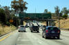
Northbound view approaching the Hollywood Way
interchange. Imagine the view of the Valley that some of those
homes would have that are visible on the mountain side directly ahead of
the Golden State Freeway. |
 |
|
Photographed by: AsphaltPlanet.ca |
Date: 3/27/2010 |
High-res:
(1440x960)
(2400x1600) |
|
Los Angeles County
City of Los Angeles
|
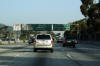
Next exit signage affixed to the Roscoe Boulevard
overpass. |
 |
|
Photographed by: AsphaltPlanet.ca |
Date: 3/27/2010 |
High-res:
(1440x960)
(2400x1600)
|
|
Los Angeles County
City of Los Angeles
|
Overhead signage at the Sunland Boulevard
interchange. Note the debris that is visible in the left hand
shoulder of the freeway. Roadside debris is far, far more common
on US freeways than it is in Canada. I don't know why, but Canada
really is cleaner than the US. |
 |
|
Photographed by: AsphaltPlanet.ca |
Date: 3/27/2010 |
High-res:
(1440x960)
(2400x1600) |
|
Los Angeles County
City of Los Angeles
|
Next exit signage prior to the Lankershim
Boulevard interchange. Note how quickly the quarter mile
progresses
between the next exit sign on the left and the advance sign on the
right. |
 |
|
Photographed by: AsphaltPlanet.ca |
Date: 3/27/2010 |
High-res:
(1440x960)
(2400x1600)
|
|
Los Angeles County
City of Los Angeles
|
Southbound signage at the off-ramp to Sheldon Street. With the
recently added carpool lane in the median shoulder, Interstate 5 just
barely squeezes beneath the Sheldon Street overcrossing. |
 |
|
Photographed by: AsphaltPlanet.ca |
Date: 4/16/2017 |
High-res:
(1440x960)
(2400x1600) |
|
Los Angeles County
City of Los Angeles
|
This southbound advanced signage for the Sheldon Street interchange is
located just before the southbound lanes of I-5 pass beneath the SR-170
interchange. |
 |
|
Photographed by: AsphaltPlanet.ca |
Date: 4/16/2017 |
High-res:
(1440x960)
(2400x1600) |
|
Los Angeles County
City of Los Angeles
|
Northbound advanced signage for the off-ramp to Osborne Street.
This single advanced sign replaced a former median mountain mounted
interchange button copy interchange sequence sign that can be seen
here (March, 2010 photo). |
 |
|
Photographed by: AsphaltPlanet.ca |
Date: 4/11/2016 |
High-res:
(1440x960)
(2400x1600)
|
|
Los Angeles County
City of Los Angeles
|
Northbound signage at the off-ramp to Osborne Street. Two of the
three incoming lanes from the SR-170 Freeway continue northerly along
the 5 Freeway making for a six lane cross-section in addition to the
Carpool Lane. |
 |
|
Photographed by: AsphaltPlanet.ca |
Date: 4/16/2017 |
High-res:
(1440x960)
(2400x1600)
|
|
Los Angeles County
City of Los Angeles
|
Southbound signage for the Osborne Street
interchange, singed with an advance lane assignment sign for the
Hollywood Freeway (CA-170). The Hollywood Freeway is a reasonable
alternative to I-5 South into Downtown Los Angeles. |
 |
|
Photographed by: AsphaltPlanet.ca |
Date: 3/27/2010 |
High-res |
|
Los Angeles County
City of Los Angeles
|
Northbound signage at the off-ramp to Terra Bella Street. |
 |
|
Photographed by: AsphaltPlanet.ca |
Date: 4/16/2017 |
High-res:
(1440x960)
(2400x1600)
|
|
Los Angeles County
City of Los Angeles
|
Northbound interchange sequence signage in advance of the Van Nuys
Boulevard interchange. |
 |
|
Photographed by: AsphaltPlanet.ca |
Date: 4/11/2016 |
High-res:
(1440x960)
(2400x1600)
|
|
Los Angeles County
City of Los Angeles
|
Signage at the northbound off-ramp to Van Nuys Boulevard. |
 |
|
Photographed by: AsphaltPlanet.ca |
Date: 4/16/2017 |
High-res:
(1440x960)
(2400x1600)
|
|
Los Angeles County
City of Los Angeles
|
Two views looking notherly approaching the SR-118 Freeway interchange.
The upper photo shows the button-copy signage as it existed before the 5
Freeway was widened between the SR-170 and SR-118 Freeways, and the
lower photo shows the signage as it exists today.
Upper photo taken: 3/27/2010
Lower photo taken:
4/16/2017 |
 |
|
High-res: (1440x960)
|
 |
|
Photographed by: AsphaltPlanet.ca |
Date: as noted |
High-res:
(1440x960)
(2400x1600)
|
|
Los Angeles County
City of Los Angeles
|
Signage at the northbound off-ramp to the SR-118 freeway. The
upper photo shows the former button copy signage, while the lower photo
shows the current signage and lane configuration. The fifth and
sixth general purpose lanes that joined the freeway at the SR-170
interchange depart the 5 Freeway at the SR-118 interchange.
Upper photo taken: 3/27/2010
Lower photo taken:
4/16/2017 |
 |
|
High-res:
(1440x960)
(2400x1600)
|
 |
|
Photographed by: AsphaltPlanet.ca |
Date:
as noted |
High-res:
(1440x960)
(2400x1600)
|
|
Los Angeles County
City of Los Angeles
|
View as the northbound off-ramp to the 118 Freeway departs from the
mainline lanes of I-5. |
 |
|
Photographed by: AsphaltPlanet.ca |
Date: 4/16/2017 |
High-res:
(1440x960)
(2400x1600)
|
|
Los Angeles County
City of Los Angeles
|
Northbound view approaching the ramp to Paxton
Street. The large Highway 118 interchange is visible just to the
north of the Paxton Street ramp. Through northern Los Angeles
County, Highway 118 is more or less a by-pass of Paxton Street.
Click here for a former button
copy version of this signage, taken in March, 2010. |
 |
|
Photographed by: AsphaltPlanet.ca |
Date: 4/16/2017 |
High-res:
(1440x960)
(2400x1600)
|
|
Los Angeles County
City of Los Angeles
|
Two northbound views view as Interstate 5 passes under the
State Route 118 interchange. I-5 is the lowest level of a four
level partial stack interchange.
Click here for an additional
view of this interchange, taken in March, 2010. |
 |
|
High-res:
(1440x960)
(2400x1600)
|
 |
|
Photographed by: AsphaltPlanet.ca |
Date: 4/16/2017 |
High-res:
(1440x960)
(2400x1600)
|
|
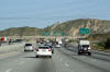
Route 118 is a long freeway that links Interstate 210
in Los Angeles County to US 101 beyond Simi Valley.
Click here for Route 118 Images. |
|
Los Angeles County
City of Los Angeles
|
Southbound view as Interstate 5 passes beneath the SR-118 interchange. |
 |
|
Photographed by: AsphaltPlanet.ca |
Date: 4/16/2017 |
High-res:
(1440x960)
(2400x1600) |
|
Los Angeles County
City of Los Angeles
|
Signage at the southbound off-ramp to Paxton Street. |
 |
|
Photographed by: AsphaltPlanet.ca |
Date: 4/16/2017 |
High-res:
(1440x960)
(2400x1600) |
|
Los Angeles County
City of Los Angeles
|
Signage at the southbound off-ramp to SR-118 East. |
 |
|
Photographed by: AsphaltPlanet.ca |
Date: 4/16/2017 |
High-res:
(1440x960)
(2400x1600) |
|
Los Angeles County
City of Los Angeles
|
Southbound advanced signage for the SR-118 interchange. There is
not a direct ramp to SR-118 West from I-5. Traffic bound for
SR-118 West must use the Paxton Street interchange. |
 |
|
Photographed by: AsphaltPlanet.ca |
Date: 4/16/2017 |
High-res:
(1440x960)
(2400x1600) |
|
Los Angeles County
City of Los Angeles
|
Northbound overhead sign at the Brand Boulevard
interchange. |
 |
|
Photographed by: AsphaltPlanet.ca |
Date: 4/16/2017 |
High-res:
(1440x960)
(2400x1600)
|
|
Los Angeles County
City of Los Angeles
|
The fourth northbound lane exits at the San Fernando Boulevard
interchange. |
 |
|
Photographed by: AsphaltPlanet.ca |
Date: 4/16/2017 |
High-res:
(1440x960)
(2400x1600)
|
|
Los Angeles County
City of Los Angeles
|
Southbound signage at the off-ramp to San Fernando Mission Boulevard. |
 |
|
Photographed by: AsphaltPlanet.ca |
Date: 4/16/2017 |
High-res:
(1440x960)
(2400x1600) |
|
Los Angeles County
City of Los Angeles
|
Southbound advanced signage for the San Fernando Mission interchange. |
 |
|
Photographed by: AsphaltPlanet.ca |
Date: 4/16/2017 |
High-res:
(1440x960)
(2400x1600) |
|
Los Angeles County
City of Los Angeles
|
Northbound advanced signage for the truck by-pass lanes around the I-405
interchange. Note that the sound barrier adjacent to the freeway
has been set back to allow the addition of an extra northbound lane
through this section of freeway. |
 |
|
Photographed by: AsphaltPlanet.ca |
Date: 4/16/2017 |
High-res:
(1440x960)
(2400x1600)
|
|
Los Angeles County
City of Los Angeles
|
Next exit signage in advance of the on-ramp
from I-405 joining the 5 Freeway. A truck by-pass ramp carries
truck traffic around the incoming ramp from I-405, ensuring that slow
moving truck traffic does not interfere with fast moving auto traffic
merging onto I-5 from the 405. Truck by-pass lanes are unique to
California, but are a very effective tool for handling heavy traffic
merges, particularly on up-hill grades.
Click here for a former button
copy version of this signage, taken in March, 2010. |
 |
|
Photographed by: AsphaltPlanet.ca |
Date: 4/16/2017 |
High-res:
(1440x960)
(2400x1600)
|
|
Los Angeles County
City of Los Angeles
|
Signage as the northbound ramp to the truck lanes at the I-405
interchange departs from the freeway mainline. Traffic from the
northbound lanes of the 405 Freeway joins the 5 Freeway just beyond this
signage. Note
the refuse that litters the side of this section of freeway.
Californians should be ashamed of themselves for allowing their
landscape to be ruined by such carelessness. |
 |
|
Photographed by: AsphaltPlanet.ca |
Date: 4/16/2017 |
High-res:
(1440x960)
(2400x1600)
|
|
Los Angeles County
City of Los Angeles
|
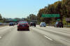
Northbound next exit signage taken as the ramp
from the San Diego Freeway (I-405) crosses underneath of the 5 Freeway. |
 |
|
Photographed by: AsphaltPlanet.ca |
Date: 3/27/2010 |
High-res
|
|
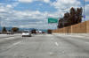
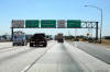
The San Diego Freeway is Interstate 405. Interstate
405 carries traffic around Downtown Los Angeles via Santa Monica before
rejoining Interstate 5 at El Toro.
Click here for Interstate 405 Images. |
|
Los Angeles County
City of Los Angeles
|
Overhead median mounted interchange sequence signage situated at the
I-405 interchange. |
 |
|
Photographed by: AsphaltPlanet.ca |
Date: 4/16/2017 |
High-res:
(1440x960)
(2400x1600) |
|
Los Angeles County
City of Los Angeles
|
Southbound overhead signage at the San Diego
Freeway interchange. The San Diego Freeway (I-405) is the Western
By-pass of Los Angeles. |
 |
|
Photographed by: AsphaltPlanet.ca |
Date: 4/16/2017 |
High-res:
(1440x960)
(2400x1600) |
|
Los Angeles County
City of Los Angeles
|
Overhead signage for the truck by-pass lane that
carries southbound trucks around the 405 Freeway interchange. It
is somewhat surprising that the truck lanes that carry transport trucks
around the 405 interchange were never linked to the truck lanes that
carry traffic around the 210 and Antelope Valley Freeway interchange's less than a
mile to the north. |
 |
|
Photographed by: AsphaltPlanet.ca |
Date: 4/12/2017 |
High-res:
(1440x960)
(2400x1600) |
|
Los Angeles County
City of Los Angeles
|
Advanced overhead signage for both the San Diego
Freeway interchange and the 405 truck by-pass lane. This photo was
taken just south of the Roxford Street interchange. |
 |
|
Photographed by: AsphaltPlanet.ca |
Date: 4/12/2017 |
High-res:
(1440x960)
(2400x1600) |
|
Los Angeles County
City of Los Angeles
|
Advanced signage for the ramp northbound ramp to Roxford Street.
From I-5 North it is a fairly involved merge to cross incoming San Diego
Freeway traffic to exit at Roxford Street. |
 |
|
Photographed by: AsphaltPlanet.ca |
Date: 3/27/2010 |
High-res:
(1440x960)
(2400x1600)
|
|
Los Angeles County
City of Los Angeles
|
Signage at the ramp to Roxford Street from
Interstate 5 North. I-5 has an interesting mix of button-copy and
reflective signage. Their often doesn't seem to be much rhyme or
reason to which button copy signs have been replaced with reflective
signage. The general age of so much of California's Freeway
infrastructure is amazing. California's mild climate does not age
concrete and steel to the same degree that a northern climate with an
annual freeze and thaw does. |
 |
|
Photographed by: AsphaltPlanet.ca |
Date: 3/27/2010 |
High-res:
(1440x960)
(2400x1600)
|
|
Los Angeles County
City of Los Angeles
|
Southbound lane assignment signage at the off-ramp to Roxford Street. |
 |
|
Photographed by: AsphaltPlanet.ca |
Date: 4/12/2017 |
High-res:
(1440x960)
(2400x1600) |
|
Los Angeles County
City of Los Angeles
|
Southbound advanced signage for the Roxford Street interchagne. |
 |
|
Photographed by: AsphaltPlanet.ca |
Date: 4/12/2017 |
High-res:
(1440x960)
(2400x1600) |
|
Los Angeles County
City of Los Angeles
|
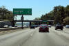
Northbound next exit signage in advance of the
Foothill Freeway interchange. |
 |
|
Photographed by: AsphaltPlanet.ca |
Date: 3/27/2010 |
High-res |
|
Los Angeles County
City of Los Angeles
|
Southbound next exit signage in advance of the
Roxford Street interchange. |
 |
|
Photographed by: AsphaltPlanet.ca |
Date: 3/27/2010 |
High-res |
|
Los Angeles County
City of Los Angeles
|
Northbound guide signage for the ramp to I-210
East. Interstate 210 isn't a major draw for traffic heading north
along the Golden State Freeway. While the 210 is indeed an
east-west highway, it has a distinctive south-easterly track from I-5
until in intersects with the Ventura Freeway in Pasadena.
Actually, given the shear number of partial freeway to freeway
interchange that exist in the State of California, it is surprising that their is
a ramp from I-5 North to I-210 East and vice versa. |
 |
|
Photographed by: AsphaltPlanet.ca |
Date: 3/27/2010 |
High-res:
(1440x960)
(2400x1600)
|
|
Los Angeles County
City of Los Angeles
|
Advanced signage for the ramp to I-5's truck lanes
that by-pass traffic incoming from I-210 and outgoing traffic to the
Antelope Valley Freeway (CA-14). |
 |
|
Photographed by: AsphaltPlanet.ca |
Date: 3/27/2010 |
High-res:
(1440x960)
(2400x1600)
|
|
Los Angeles County
City of Los Angeles
|
Ramp to the northbound truck route along I-5 as
the Golden State Freeway passes underneath of the ramp from I--210 West
to I-5 South. Truck by-pass lanes are common at major interchanges
in Southern California. They are very effective at separating slow
moving truck traffic from high speed auto traffic that would ordinarily
have to intertwine at high volume interchanges. Truck by-passes
are most effective at separating slow moving trucks from high volume exit
ramps located on or just after long uphill grades. |
 |
|
Photographed by: AsphaltPlanet.ca |
Date: 3/27/2010 |
High-res
|
|
The Foothill Freeway is Interstate 210.
I-210 carries traffic southeasterly from Interstate 5 towards Pasadena
and San Bernardino and beyond.
Click here for Interstate 210 Images. |
|
Los Angeles County
City of Los Angeles
|
Pull-through overhead signage at the southbound
ramp to the Foothills Freeway. |
 |
|
Photographed by: AsphaltPlanet.ca |
Date: 3/27/2010 |
High-res |
|
Los Angeles County
City of Los Angeles
|
Southbound advanced signage for the Foothills
Freeway. Note the double overhead signage, surrounding the Balboa
Boulevard overpass pier. The carriageway to the right of the
one that I am driving in are the truck lanes, which have their own
dedicated exit to the Foothills Freeway. |
 |
|
Photographed by: AsphaltPlanet.ca |
Date: 3/27/2010 |
High-res |
|
Los Angeles County
City of Los Angeles
|
View looking northerly approaching the Balboa
Boulevard overpass. At this point, traveling northbound, the ramp from the Foothill Freeway (I-120) has just merged
with mainline traffic. The pull through signs that appear to the
right (east) of the mainline lanes services the truck lanes that exist
along I-5 between the I-210 and CA-14 interchanges. |
 |
|
Photographed by: AsphaltPlanet.ca |
Date: 3/27/2010 |
High-res:
(1440x960)
(2400x1600)
|
|
Los Angeles County
City of Los Angeles
|
Signage at the start of the Carpool Lane Ramp to SR-14, the Antelope
Valley Freeway. |
 |
|
Photographed by: AsphaltPlanet.ca |
Date: 3/27/2010 |
High-res:
(1440x960)
(2400x1600)
|
|
Los Angeles County
City of Los Angeles
|
Advanced lane assignment signage approaching the SR-14 interchange. |
 |
|
Photographed by: AsphaltPlanet.ca |
Date: 3/27/2010 |
High-res:
(1440x960)
(2400x1600)
|
|
Los Angeles County
City of Los Angeles
|
Pull-through signage as the three lane ramp to the
Antelope Valley Freeway departs from Interstate 5 North.
Click here to see this
signage, taken in March, 2010 before the Carpool lane flyover was
constructed between the two freeways. |
 |
|
Photographed by: AsphaltPlanet.ca |
Date: 3/27/2010 |
High-res:
(1440x960)
(2400x1600)
|
|
Los Angeles County
City of Los Angeles
|
View looking northerly as Interstate 15 passes through the SR-14
interchange. |
 |
|
Photographed by: AsphaltPlanet.ca |
Date: 3/27/2010 |
High-res:
(1440x960)
(2400x1600)
|
|
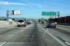
The Antelope Valley Freeway is Highway 14.
Highway 14 carries traffic northeasterly from Interstate 5 through to
Lancaster, and Mojave and beyond.
Click here for Highway 14 Images. |
|
Los Angeles County
City of Los Angeles
|
Southbound overhead signage for the southbound ramp to
Highway 14. |
 |
|
Photographed by: AsphaltPlanet.ca |
Date: 3/27/2010 |
High-res:
(1440x960)
(2400x1600) |
|
Los Angeles County
City of Los Angeles
|
Southbound overhead signage for the truck by-pass
lanes along Interstate 5. At CA-14, the southbound truck by-pass
lanes actually pass underneath of the mainline interstate lanes and form
their own mini-freeway opposite the northbound truck-by-pass lanes on
the other side of the narrow ravine that contains the freeway. |
 |
|
Photographed by: AsphaltPlanet.ca |
Date: 3/27/2010 |
High-res:
(1440x960)
(2400x1600) |
|
Los Angeles County
City of Los Angeles
|
A backlit advanced sign assembly for both the
Highway 14 interchange, and the associated truck by-pass lanes to carry
truck traffic around the Highway 14 interchange. |
 |
|
Photographed by: AsphaltPlanet.ca |
Date: 3/27/2010 |
High-res:
(1440x960)
(2400x1600) |
|
Los Angeles County
City of Santa Clarita
|
Advanced signage directing truck traffic to keep
right for southbound truck lane that by-passes the Highway 14
interchange. |
 |
|
Photographed by: AsphaltPlanet.ca |
Date: 3/27/2010 |
High-res |
|
Los Angeles County
City of Santa Clarita
|
Looking into the early morning sun heading south
on I-5 approaching the Calgrove Boulevard interchange. Calgrove
Boulevard is the southernmost interchange in Santa Clarita. |
 |
|
Photographed by: AsphaltPlanet.ca |
Date: 3/27/2010 |
High-res |
|
Los Angeles County
City of Santa Clarita
|
Southbound next exit signage in advance of the
Calgrove Boulevard interchange. Truck Route signage is always
signed with black lettering on a white background as is indicated on
this signage. |
 |
|
Photographed by: AsphaltPlanet.ca |
Date: 3/27/2010 |
High-res |
|
Los Angeles County
City of Santa Clarita
|
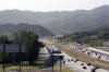
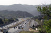
Two southerly views from the Pico Canyon Road
overpass. I-5 passes through the Gavin Canyon through the Susana
Mountains between Santa Clarita and Los Angeles. The mountainous
terrain of Southern California is the only obstacle to the never ending
sprawl of Los Angeles. The City of Santa Clarita was only
incorporated in 1987, a fact that highlights how quickly and recently
the City of Los Angeles has crept into the former rural foothills of of
Southern California. |
 |
|
High-res:
(1440x960)
(2400x1600) |
 |
|
Photographed by: AsphaltPlanet.ca |
Date: 3/27/2010 |
High-res:
(1440x960)
(2400x1600) |
|
Los Angeles County
City of Santa Clarita
|
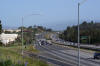
This view looks northerly from the Pico Canyon
Road overpass. A typical highway commercial shopping centre has
sprouted up adjacent to the interstate in Santa Clarita at Pico Canyon
Road. |
 |
|
Photographed by: AsphaltPlanet.ca |
Date: 3/27/2010 |
High-res:
(1440x960)
(2400x1600) |
|
Los Angeles County
City of Santa Clarita
|
Southbound signage at the off-ramp to Pico Canyon Road. |
 |
|
Photographed by: AsphaltPlanet.ca |
Date: 4/15/2017 |
High-res:
(1440x960)
(2400x1600) |
|
Los Angeles County
City of Santa Clarita
|
Southbound interchange sequence signage approaching the Pico Canyon Road
interchange. |
 |
|
Photographed by: AsphaltPlanet.ca |
Date: 4/15/2017 |
High-res:
(1440x960)
(2400x1600) |
|
Los Angeles County
City of Santa Clarita
|
The Valencia Boulevard advanced signage is affixed
to the McBean Parkway overpass. |
 |
|
Photographed by: AsphaltPlanet.ca |
Date: 3/27/2010 |
High-res
|
|
Los Angeles County
City of Santa Clarita
|
Southbound signage affixed the McBean Parkway overpass for the Pico
Canyon Road interchange. |
 |
|
Photographed by: AsphaltPlanet.ca |
Date: 4/15/2017 |
High-res:
(1440x960)
(2400x1600) |
|
Los Angeles County
City of Santa Clarita
|
Signage at the southbound off-ramp to McBean Parkway. |
 |
|
Photographed by: AsphaltPlanet.ca |
Date: 4/15/2017 |
High-res:
(1440x960)
(2400x1600) |
|
Los Angeles County
City of Santa Clarita
|
Next exit signage in advance of the Valencia
Boulevard interchange. The mountains of the Angeles National
Forest climb higher and higher in the distance beyond the signage.
I-5 passes overtop of a considerable mountain range before reaching
California's Central Valley some 55 Miles northerly. |
 |
|
Photographed by: AsphaltPlanet.ca |
Date: 3/27/2010 |
High-res:
(1440x960)
(2400x1600)
|
|
Los Angeles County
City of Santa Clarita
|
The ramp to Valencia Boulevard departs the freeway
in advance of the Valencia Boulevard overpass. Note the embossed
pattern that has been incorporated into the facade of the Valencia
Boulevard overpass. Caltrans has placed considerable effort to improve the aesthetics of freeways in California. For
a time, seemingly no emphasis was placed on freeway aesthetics in California,
particularly within Los Angeles. Whether deliberate or not, many
L.A. area freeways have a distinctly 'concrete jungle' style to them. |
 |
|
Photographed by: AsphaltPlanet.ca |
Date: 3/27/2010 |
High-res:
(1440x960)
(2400x1600)
|
|
Los Angeles County
City of Santa Clarita
|
Approaching the northbound Magic Mountain Parkway
interchange. Magic Mountain Parkway receives its name from the Six
Flags Magic Mountain Park that is situated adjacent to the Interstate,
and is visible in this photo. |
 |
|
Photographed by: AsphaltPlanet.ca |
Date: 3/27/2010 |
High-res:
(1440x960)
(2400x1600)
|
|
Los Angeles County
City of Santa Clarita
|
Advanced signage for the Highway 126 interchange.
Highway 126 extends westerly from Interstate 5 into Ventura County.
Highway 126 is not a freeway. |
 |
|
Photographed by: AsphaltPlanet.ca |
Date: 3/27/2010 |
High-res:
(1440x960)
(2400x1600)
|