|
|
|
|
|
|
South-
Bound
|
|
Orange County
City of Irvine
|
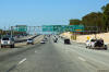
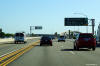
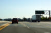
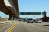
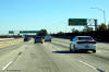
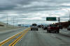
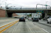
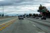
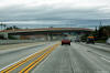
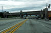
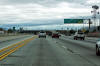
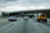
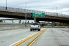
Northbound advanced signage for the off-ramp to Lake Forest Drive. |
 |
|
Photographed by: AsphaltPlanet.ca |
Date: 10/30/2013 |
High-res:
(1440x960)
(2400x1600)
|
|
Orange County
City of Irvine
|
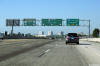
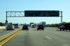
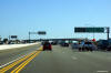
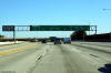
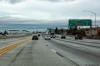
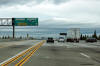
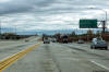
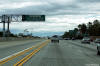
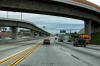
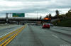
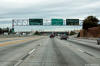
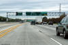
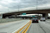
Northbound advanced signage in advance of the I-405 interchange. |
 |
|
Photographed by: AsphaltPlanet.ca |
Date: 10/30/2013 |
High-res:
(1440x960)
(2400x1600)
|
|
Orange County
City of Irvine
|
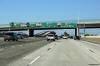
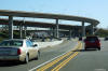
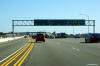
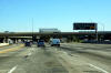
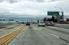
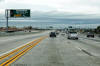
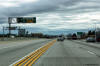
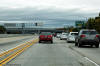
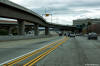
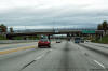
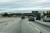
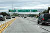
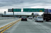
View looking northerly at the start of the 405 Freeway at the El Toro
'Y' interchange. |
 |
|
Photographed by: AsphaltPlanet.ca |
Date: 10/30/2013 |
High-res:
(1440x960)
(2400x1600)
|
|
Orange County
City of Irvine
|
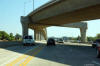
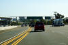
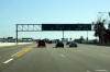
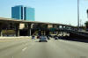
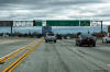
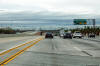
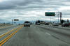
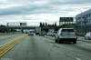
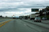
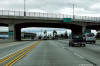
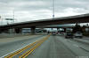
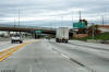
Southerly view as Interstate 5 passes beneath the
flyover that carries HOV traffic between I-5 and I-405. |
 |
|
Photographed by: AsphaltPlanet.ca |
Date: 10/30/2013 |
High-res:
(1440x960)
(2400x1600) |
|
Orange County
City of Irvine
|
Southbound view as the I-5 truck lanes exit the
mainline lanes of the interstate in advance of the El Toro Y interchange
with I-405. |
 |
|
Photographed by: AsphaltPlanet.ca |
Date: 10/30/2013 |
High-res:
(1440x960)
(2400x1600) |
|
Orange County
City of Irvine
|
Southbound advanced signage approaching the El
Toro Y interchange. |
 |
|
Photographed by: AsphaltPlanet.ca |
Date: 10/30/2013 |
High-res:
(1440x960)
(2400x1600) |
|
Orange County
City of Irvine
|
Southerly view looking through the southern SR-133
interchange. |
 |
|
Photographed by: AsphaltPlanet.ca |
Date: 10/30/2013 |
High-res:
(1440x960)
(2400x1600) |
|
Orange County
City of Irvine
|
Southbound view at the off-ramp to Highway 55
South. The elevated structure in the median of the freeway is the
high-speed HOV connector that links the HOV lanes on I-5 to those on
Highway 55. |
 |
|
Photographed by: AsphaltPlanet.ca |
Date: 10/30/2013 |
High-res:
(1440x960)
(2400x1600) |
|
Orange County
City of Irvine
|
Southbound advanced signage approaching the SR-133
South interchange. |
 |
|
Photographed by: AsphaltPlanet.ca |
Date: 10/30/2013 |
High-res:
(1440x960)
(2400x1600) |
|
Orange County
City of Irvine
|
The southbound off-ramp to Sand Canyon Avenue
passes beneath the off-ramp from I-5 South to SR-133 North. |
 |
|
Photographed by: AsphaltPlanet.ca |
Date: 10/30/2013 |
High-res:
(1440x960)
(2400x1600) |
|
Orange County
City of Irvine
|
Signage at the southbound off-ramp to Toll-133
North. |
 |
|
Photographed by: AsphaltPlanet.ca |
Date: 10/30/2013 |
High-res:
(1440x960)
(2400x1600) |
|
Orange County
City of Santa Ana
|
Southbound advanced signage for the ramp to
Toll-133 North. |
 |
|
Photographed by: AsphaltPlanet.ca |
Date: 10/30/2013 |
High-res:
(1440x960)
(2400x1600) |
|
Orange County
City of Santa Ana
|
Southbound view at the off-ramp to Highway 55
South. The elevated structure in the median of the freeway is the
high-speed HOV connector that links the HOV lanes on I-5 to those on
Highway 55. |
 |
|
Photographed by: AsphaltPlanet.ca |
Date: 10/30/2013 |
High-res:
(1440x960)
(2400x1600) |
|
Orange County
City of Santa Ana
|
While the mainline lanes of I-5 pass underneath the Fourth Street
overpass, the HOV lane flyover passes over the Fourth Street overpass. |
 |
|
Photographed by: AsphaltPlanet.ca |
Date: 10/30/2013 |
High-res:
(1440x960)
(2400x1600) |
|
Orange County
City of Santa Ana
|
Southbound signage at the ramp from I-5 South to
SR-22 East. |
 |
|
Photographed by: AsphaltPlanet.ca |
Date: 10/30/2013 |
High-res:
(1440x960)
(2400x1600) |
|
Orange County
City of Santa Ana
|
Full width overhead signage at the ramp to SR-22
West. On close inspection of the pull through signage for I-5
South, it is evident that the signage has been designed for an eventual
five through lane cross-section. |
 |
|
Photographed by: AsphaltPlanet.ca |
Date: 10/30/2013 |
High-res:
(1440x960)
(2400x1600) |
|
Orange County
City of Santa Ana
|
Southbound advanced signage for the SR-22
interchange. |
 |
|
Photographed by: AsphaltPlanet.ca |
Date: 10/30/2013 |
High-res:
(1440x960)
(2400x1600) |
|
Orange County
City of Santa Ana
|
Partial overhead signage for the northbound ramp
to Chapman Avenue. As much as I love southern California, note the
copious amounts of road side litter and other debris along the inner
shoulder of the highway. Unfortunately, California has a problem |
 |
|
Photographed by: AsphaltPlanet.ca |
Date: 12/16/2014 |
High-res:
(1440x960)
(2400x1600)
|
|
Orange County
City of Santa Ana
|
Exit signage for the northbound exit to both State College Boulevard and
The City Drive. |
 |
|
Photographed by: AsphaltPlanet.ca |
Date: 12/16/2014 |
High-res:
(1440x960)
(2400x1600)
|
|
Orange County
City of Santa Ana
|
Pull-through southbound advanced signage for the
SR-22 (Orange Crush) interchange. |
 |
|
Photographed by: AsphaltPlanet.ca |
Date: 12/16/2014 |
High-res:
(1440x960)
(2400x1600) |
|
Orange County
City of Santa Ana
|
Southbound Signage for the ramp to State College
Boulevard, the City Drive and Chapman Avenue. |
 |
|
Photographed by: AsphaltPlanet.ca |
Date: 12/16/2014 |
High-res:
(1440x960)
(2400x1600) |
|
Orange County
City of Anaheim
|
Northbound advanced signage for the Carpool Lane ramp to Gene Autry Way
and Disney Way. |
 |
|
Photographed by: AsphaltPlanet.ca |
Date: 12/16/2014 |
High-res:
(1440x960)
(2400x1600)
|
|
Orange County
City of Anaheim
|
Northbound signage for the Carpool Lane ramp to both Gene Autry Way and
Disney Way. |
 |
|
Photographed by: AsphaltPlanet.ca |
Date: 12/16/2014 |
High-res:
(1440x960)
(2400x1600)
|
|
Orange County
City of Anaheim
|
Northbound advanced signage for the ramp to
Katella Avenue |
 |
|
Photographed by: AsphaltPlanet.ca |
Date: 12/16/2014 |
High-res:
(1440x960)
(2400x1600)
|
|
Orange County
City of Anaheim
|
The northbound exit to Katella Avenue and Disney Way is situated just
beyond the Gene Autry Way overpass. |
 |
|
Photographed by: AsphaltPlanet.ca |
Date: 12/16/2014 |
High-res:
(1440x960)
(2400x1600)
|
|
Orange County
City of Anaheim
|
Southbound advanced signage situated in advance of
the Gene Autry Way overpass. |
 |
|
Photographed by: AsphaltPlanet.ca |
Date: 12/16/2014 |
High-res:
(1440x960)
(2400x1600) |
|
Orange County
City of Anaheim
|
Southbound view at the at the off-ramp to Gene
Autry Way from the Carpool Lane. |
 |
|
Photographed by: AsphaltPlanet.ca |
Date: 12/16/2014 |
High-res:
(1440x960)
(2400x1600) |
|
Orange County
City of Anaheim
|
Southbound view at the off-ramp to both Katella
and Orangewood Avenue. |
 |
|
Photographed by: AsphaltPlanet.ca |
Date: 12/16/2014 |
High-res:
(1440x960)
(2400x1600) |
|
Orange County
City of Anaheim
|
Southerly view at the ramp to Disney Way and
Anaheim Boulevard. |
 |
|
Photographed by: AsphaltPlanet.ca |
Date: 12/16/2014 |
High-res:
(1440x960)
(2400x1600) |
|
Orange County
City of Anaheim
|
Southbound advanced signage for the Carpool ramp
to Gene Autry Way. |
 |
|
Photographed by: AsphaltPlanet.ca |
Date: 12/16/2014 |
High-res:
(1440x960)
(2400x1600) |
|
Orange County
City of Anaheim
|
Northbound view at the off-ramp to Harbor Boulevard and Ball Road. |
 |
|
Photographed by: AsphaltPlanet.ca |
Date: 12/16/2014 |
High-res:
(1440x960)
(2400x1600)
|
|
Orange County
City of Anaheim
|
Southbound view at the off-ramp to Harbor Boulevard. |
 |
|
Photographed by: AsphaltPlanet.ca |
Date: 12/16/2014 |
High-res:
(1440x960)
(2400x1600) |
|
Orange County
City of Anaheim
|
Two views looking northerly as I-5 passes beneath
the Carpool Lane flyover that links Disneyland to the I-5 Carpool Lanes. |
 |
|
High-res:
(1440x960)
(2400x1600)
|
 |
|
Photographed by: AsphaltPlanet.ca |
Date: 12/16/2014 |
High-res:
(1440x960)
(2400x1600)
|
|
Orange County
City of Anaheim
|
Southerly view along I-5 as the highway passes
through the Disneyland interchange. |
 |
|
Photographed by: AsphaltPlanet.ca |
Date: 12/16/2014 |
High-res:
(1440x960)
(2400x1600) |
|
Orange County
City of Anaheim
|
Southbound signage at the off-ramp to Disneyland
Drive and Ball Road. |
 |
|
Photographed by: AsphaltPlanet.ca |
Date: 12/16/2014 |
High-res:
(1440x960)
(2400x1600) |
|
Orange County
City of Anaheim
|
Southbound signage at the ramp from the Carpool
Lanes to Disneyland Drive. |
 |
|
Photographed by: AsphaltPlanet.ca |
Date: 12/16/2014 |
High-res:
(1440x960)
(2400x1600) |
|
Orange County
City of Anaheim
|
Southbound advanced signage for the Carpool Lane
ramp to Disneyland Drive. |
 |
|
Photographed by: AsphaltPlanet.ca |
Date: 12/16/2014 |
High-res:
(1440x960)
(2400x1600) |
|
Orange County
City of Anaheim
|
View looking northerly at the off-ramp to Lincoln Avenue. |
 |
|
Photographed by: AsphaltPlanet.ca |
Date: 12/16/2014 |
High-res:
(1440x960)
(2400x1600) |
|
Orange County
City of Anaheim
|
Two views looking southerly at the off-ramp to
Lincoln Avenue. |
 |
|
High-res:
(1440x960)
(2400x1600) |
 |
|
Photographed by: AsphaltPlanet.ca |
Date: 12/16/2014 |
High-res:
(1440x960)
(2400x1600) |
|
Orange County
City of Anaheim
|
Southerly view at the off-ramp to Euclid Street. |
 |
|
Photographed by: AsphaltPlanet.ca |
Date: 12/16/2014 |
High-res:
(1440x960)
(2400x1600) |
|
Orange County
City of Anaheim
|
Signage at the off-ramp to Brookhurst Street. |
 |
|
Photographed by: AsphaltPlanet.ca |
Date: 12/16/2014 |
High-res:
(1440x960)
(2400x1600) |
|
Orange County
City of Anaheim
|
Northbound signage at the off-ramp to La Palma
Avenue East. |
 |
|
Photographed by: AsphaltPlanet.ca |
Date: 12/16/2014 |
High-res:
(1440x960)
(2400x1600) |
|
Orange County
City of Anaheim
|
Southbound view at the off-ramp to Brookhurst
Street and La Palma Avenue. |
 |
|
Photographed by: AsphaltPlanet.ca |
Date: 12/16/2014 |
High-res:
(1440x960)
(2400x1600) |
|
Orange County
City of Anaheim
|
Northbound signage in advance of the 91 Freeway
interchange. There are no direct connector ramps between I-5 North
and the 91 East or vice versa due to the heavy skew of the freeways. |
 |
|
Photographed by: AsphaltPlanet.ca |
Date: 12/16/2014 |
High-res:
(1440x960)
(2400x1600) |
|
Orange County
City of Anaheim
|
Signage at the off-ramp to the 91 Freeway West. |
 |
|
Photographed by: AsphaltPlanet.ca |
Date: 12/16/2014 |
High-res:
(1440x960)
(2400x1600) |
|
Orange County
City of Anaheim
|
Access to the eastbound direction of the 91
Freeway is provided via Magnolia Avenue. |
 |
|
Photographed by: AsphaltPlanet.ca |
Date: 12/16/2014 |
High-res:
(1440x960)
(2400x1600) |
|
Orange County
City of Anaheim
|
Northbound signage at the Carpool Lane ramp to the westbound 91 Freeway. |
 |
|
Photographed by: AsphaltPlanet.ca |
Date: 12/16/2014 |
High-res:
(1440x960)
(2400x1600)
|
|
The 91 Freeway is a long east-west freeway that runs
through the northern portion of Orange County from Los Angeles to
Riverside. Click here for
SR-91 Images. |
|
Orange County
City of Buena Park
|
Southbound signage for the Carpool Lane exit to
the 91 Freeway east. |
 |
|
Photographed by: AsphaltPlanet.ca |
Date: 12/16/2014 |
High-res:
(1440x960)
(2400x1600) |
|
Orange County
City of Buena Park
|
Southbound signage at the off-ramp to the
eastbound lanes of the 91 Freeway. |
 |
|
Photographed by: AsphaltPlanet.ca |
Date: 12/16/2014 |
High-res:
(1440x960)
(2400x1600) |