King's Highway 49 - www.OntHighways.com

Before downloading Highway 49 extended south from Highway 401 near Marysville, crossing the Bay of Quinte via the high level Skyway bridge, and ending in Picton in Prince Edward County.  Highway 49 provides the only direct connection to the Island of Prince Edward that does not force travelers to pass through a built up area.  It was a very useful (albeit under-traveled) highway, and was almost totally decommissioned on January 1st, 1998.  The only reason that Highway 49 still exists to this day, is that also on January 1st, 1998, Hastings County downloaded their entire county network onto the local municipalities for them to maintain.  The small Indian Reserve of Tyendinaga refused to assume control over any portion of Highway 49, as their small community simply could not afford the financial burden of maintaining a provincially significant route.

This highway 49 is the second Highway 49 to exist in Ontario.  The first Highway 49 existed from the 1930s to the 1960s between Highway 50 and 27 in York Region.  The original Highway 49 is now known as York Road 49.  More information can be found here (at TheKingsHighway.ca)


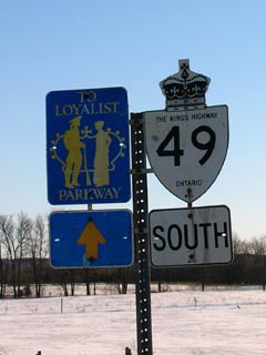
 Highway 49 marker cosigned with a Loyalist Parkway trailblazer.


Southern Terminus:  Pre-1998: Junction Highway 33 (Loyalist Parkway) in downtown Picton

                                         Currently:  At the Southern End of the Bay of Quinte Skyway Bridge.

Northern Terminus:  Pre-1998:  At Highway 401 (Exit 566)

                                        Currently:  At the Northern Limits of the Tyendinaga Indian Reserve.

Length:  Pre-1998: 28.3 km.  Currently: 6.1 km.

Multiplexes:  Before downloading there was a 4.2 Km with Highway 2 (this multiplex is still signed, though it is no longer a legal co-designation).

Freeway:  No

AADT (1994):  Highest:  3,700 from Picton northerly to the Picton Golf & Country Club;

                             Lowest:  1,950 along the Highway 2 multiplex.

Road Info:  On the mainland, Highway 49 is in great shape, with nice smooth pavement.  In Prince Edward County, most of Highway 49 is paved with concrete that is starting to show its age.  The rural speed limit along Highway 49 is 80km/h.


Highway 49 information:


OntHighways.com  

Detailed Route information available below
Virtual Tour of Highway 49


TheKingsHighway.ca   History of Highway 49
Photographic History of Highway 49

Communities and Major Intersections along Highway 49 from South to North:

Proper Municipality Name Community Name Distance Intersecting Road

In Prince Edward County Highway 49 is known as Prince Edward Road 49

Municipality of Prince Edward County Picton 0 km / 28. 3 km King's Highway 33 (Loyalist Parkway)
Municipality of Prince Edward County Picton ----- Johnson Street (Prince Edward Road 5)
Municipality of Prince Edward County Picton North Limits 1.1 km / 27.2 km -----
Municipality of Prince Edward County ----- 3.2 km / 25.1 km Prince Edward Road 6
Municipality of Prince Edward County Woodville --- -----
Municipality of Prince Edward County Roblin Mills 13.8 km / 14.4 km Prince Edward Road 35
Municipality of Prince Edward County ----- 19.8 km / 8.5 km Prince Edward Road 15

Current Southern Terminus of Highway 49 is located at the southern end of the Skyway bridge.

Tyendinaga Indian Reserve 38 ----- 21.2 km / 8.5 km Hastings Road 16
Tyendinaga Indian Reserve 38 ----- 22.9 km / 5.4 km Highway 2-East (Hastings Road 2)

Current Northern Terminus of Highway 49 is located at the Northern Limits of the Tyendinaga Indian Reserve

North of Tyendinaga, Highway 49 has not been re-designated, and is still for the most part signed is still signed as Highway 49, but is likely known as Marysville Road

Tyendinaga IR - Tyendinaga Twp Boundary ----- 26.3 km / 2.0 km -----
Township of Tyendinaga Marysville 27.1 km / 1.2 km Highway 2-West (Hastings Road 2)& Hastings Road 24.
Township of Tyendinaga ----- 28.3 km / 0 km King's Highway 401 (Autoroute Macdonald-Cartier Freeway)

Highway 49 ENDS


<-  Highway 48          www.OntHighways.com - Home          Highway 50 ->


Copyright (c) 2004-2010, AsphaltPlanet.ca  AsphaltPlanet@asphaltplanet.ca

Page last updated:  March 4th, 2005

Page created:  March 20th, 2004