|
Proper Municipality Name |
Community Name |
Distance |
Intersecting Road |
|
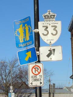
In Hastings County Highway
33 has been downloaded and is known as Hastings / Quinte West
Road 33 |
| Township of Stirling - Rawdon |
Stirling |
0 km / 138.1 km |
Highway 14 (Hastings Road 14) |
|
At Hastings Road 8: SB: Turn Left onto
Frankford-Stirling Road on west side of Stirling. NB: Turn right
towards Highway 14 upon Entering Stirling |
| Township of Stirling- Rawdon |
Stirling |
--- |
Hastings Road 8 |
| Stirling- Rawdon - Quinte West Boundary |
Stirling - Trenton Limits |
1.7 km / 136.4 km |
----- |
| City of Quinte West |
River Valley |
--- |
----- |
| City of Quinte West |
(Former) Frankford North
Limits |
10.4 km / 127.7 km |
----- |
| City of Quinte West |
Frankford |
11.8 km / 126.3 km |
Riverside Parkway (Quinte West Road 4) |
|
At Frankford Road: SB: Turn
Right to cross the Trent River Bridge. NB: Turn Left towards Stirling. |
| City of Quinte West |
Frankford |
12.0 km / 126.2 km |
Frankford Road (Quinte West Road 5-East) |
|
At Mill Street-West: SB:
Turn Left towards Trenton. NB: Turn Right to cross the Trent River
Bridge. |
| City of Quinte West |
Frankford |
12.5 km / 125.6 km |
Mill Street (West) (Quinte West Road 5-West) |
| City of Quinte West |
(Former) Frankford South
Limits |
14.1 km / 124.0 km |
----- |
| City of Quinte West |
----- |
18.7 km / 119.5 km |
Johnstown Road (Quinte West Road 4) |
| City of Quinte West |
----- |
21.1 km / 118.5 km |
King's Highway 401
(Autoroute Macdonald - Cartier Freeway) |
|
At Telephone Road &
Stockdale Road: SB: Turn Left towards Downtown Trenton. NB:
Follow the ramp to the right towards Highway 401. |
| City of Quinte West |
----- |
22.5 km / 115.7 km |
Stockdale Road & Telephone Road (Formerly
Northumberland Road 42) |
| City of Quinte West |
(Former) Trenton North
Limits |
22.6 km / 115.6 km |
----- |
|
At Dixon Drive: SB: Follow
the ramp to the right towards Dundas Street. NB: Turn Left onto Front
Street. |
| City of Quinte West |
Trenton |
24.6 km / 113.5 km |
Dixon Drive |
|
At Dundas Street East: SB:
Turn Right onto Dundas Street. NB: Turn Left onto Division Street. |
| City of Quinte West |
Trenton |
25.2 km / 113.0 km |
Highway 2-East (Dundas Street, Quinte West Road
2). |
|
At Dundas Street West: EB:
Turn left on Dufferin Avenue. NB: Turn Right onto Dundas Street |
| City of Quinte West |
Trenton |
25.7 km / 112.5 km |
Highway 2-West (Dundas Street, Quinte West Road
2). |
| City of Quinte West |
(Former)
Trenton South Limits |
27.8 km / 109.4 km |
----- |
| City of Quinte West |
----- |
29.6 km / 108.6 km |
Wooler Road (Quinte West Road 40) |
|
Quinte West - Prince Edward
Boundary: Highway 33 is now known as Prince Edward Road 33 in Prince
Edward County. In Quinte West, Highway 33 is known as Quinte West Road
33. |
| Municipality of Prince Edward County |
Carrying Place |
32.7 km / 105.4 km |
Old Portage Road (Quinte West-Prince Edward Road
64) |
| Municipality of Prince Edward County |
Carrying Place |
32.8 km / 105.3 km |
Prince Edward Road 3 |
| Municipality of Prince Edward County |
----- |
37.3 km / 100.8 km |
Prince Edward Road 19 |
| Municipality of Prince Edward County |
Consecon Station |
40.0 km / 98.2 km |
Mill Street (Prince Edward Road 29-North Jct) |
| Municipality of Prince Edward County |
----- |
41.3 km / 96.8 km |
Prince Edward Road 29-South Jct & Prince Edward Road 1 |
| Municipality of Prince Edward County |
----- |
44.8 km / 93.4 km |
North Beach Road (Prince Edward Road 27) |
| Municipality of Prince Edward County |
Hillier |
--- |
----- |
| Municipality of Prince Edward County |
Rosehall |
--- |
----- |
| Municipality of Prince Edward County |
----- |
54.0 km / 84.1 km |
Huyck's Road (Prince Edward Road 20) |
| Municipality of Prince Edward County |
(Former) Wellington West
Limits |
57.7 km / 80.5 km |
----- |
| Municipality of Prince Edward County |
Wellington |
59.4 km / 78.8 km |
Consecon Street |
| Municipality of Prince Edward County |
Wellington |
--- |
Townline Road (Prince Edward Road 2) |
| Municipality of Prince Edward County |
(Former) Wellington East
Limits |
61.5 km / 76.6 km |
----- |
| Municipality of Prince Edward County |
(Former) Bloomfield West
Limits |
68.9 km / 69.2 km |
----- |
|
Current
Western Terminus of
Highway 33 is located at Highway 62 in Picton |
|
At Highway 62: EB: Turn
Right towards Picton. WB: Turn Left away from Highway 62 towards
Wellington |
| Municipality of Prince Edward County |
Bloomfield |
70.0 km / 68.5 km |
King's Highway 62
(Stanley Street) |
| Municipality of Prince Edward County |
Bloomfield |
70.2 km / 67.9 km |
West Lake Road (Prince Edward Road 12) |
| Municipality of Prince Edward County |
(Former) Bloomfield East
Limits |
72.1 km / 66.1 km |
----- |
| Municipality of Prince Edward County |
----- |
--- |
Mallory Road (Prince Edward Road 32) |
| Municipality of Prince Edward County |
Warings Corner |
74.8 km / 63.4 km |
Schoharie Road (Prince Edward Road 1) |
| Municipality of Prince Edward County |
(Former) Picton West
Limits |
76.7 km / 61.4 km |
----- |
| Municipality of Prince Edward County |
Picton |
--- |
Lake Street (Prince Edward Road 10) & Talbot
Road (Prince Edward Road 4) |
| Municipality of Prince Edward County |
Picton |
78.3 km / 59.8 km |
Highway 49 (Prince
Edward Road 49, Main Street) |
| Municipality of Prince Edward County |
Picton |
--- |
Church Street (Prince Edward Road 22) |
| Municipality of Prince Edward County |
(Former) Picton East
Limits |
79.4 km / 58.7 km |
----- |
| Municipality of Prince Edward County |
----- |
86.2 km / 51.9 km |
Lake on the Mountain Road (Prince Edward Road 7) |
| Municipality of Prince Edward County |
Glenora (West Ferry Dock) |
86.9 km / 51.2 km |
----- |
|
Glenora Ferry (Ferry
Info) |
| Town of Greater Napanee |
Cook Point (East Ferry Dock) |
86.9 km / 51.2 km |
----- |
| Town of Greater Napanee |
Adolphustown |
91.5 km / 46.7 km |
Lennox & Addington Road 8 |
| Town of Greater Napanee |
Conway |
--- |
----- |
| Town of Greater Napanee |
Sandhurst |
--- |
----- |
| Town of Greater Napanee |
----- |
106.2 km / 31.9 km |
Lennox & Addington Road 21 |
| Town of Greater Napanee |
(Former) Bath West Limits |
111.3 km / 26.9 km |
----- |
| Town of Greater Napanee |
Bath |
114.0 km / 24.1 km |
Church Street (Lennox & Addington Road 7) |
| Town of Greater Napanee |
(Former) Bath East Limits |
115.8 km / 22.3 km |
----- |
| Town of Greater Napanee |
Millhaven |
117.5 km / 20.6 km |
Highway 133 (Camden East Road, Lennox &
Addington Road 4) |
| Town of Greater Napanee |
----- |
120.1 km / 18.0 km |
Jim Snow Road (Prince Edward Road 26) |
| Town of Greater Napanee |
Bayview |
124.3 km / 13.8 km |
Odessa Road (Lennox & Addington Road 6) |
| Town of Greater Napanee |
Amherstview |
126.3 km / 11.8 km |
Sherwood Avenue |
| Greater Napanee - Kingston Boundary |
Kingston West Limits |
127.7 km / 10.5 km |
Coronation Road (Lennox & Addington / Frontenac
Road 24) |
| City of Kingston |
Collins Bay |
130.1 km / 8.0 km |
Collins Bay Road (Formerly Frontenac Road 2) |
|
Current Western terminus of
Highway 33 is located at Collins Bay Road |
|
East of Collins Bay Road, Highway
33 is known as Kingston Road 33 |
| City of Kingston |
Kingston |
131.4 km / 6.7 km |
Bayridge Road (via Cloverdale Road) |
| City of Kingston |
Kingston |
133.3 km / 4.8 km |
Days Road |
| City of Kingston |
Kingston |
133.6 km / 4.5 km |
Gardiners Road (Kingston Road 6) |
| City of Kingston |
(Former) Kingston West
Limits |
135.6 km / 2.5 km |
----- |
| City of Kingston |
Kingston |
--- |
Portsmouth Avenue |
| City of Kingston |
Kingston |
--- |
Sir John A. Macdonald Avenue |
| City of Kingston |
Kingston |
138.1 km / 0 km |
Highway 2 (Kingston
Road 2, Princess Street) |
|
Highway 33 ENDS |