|
Proper Municipality Name |
Community Name |
Distance* |
Intersecting Road |
|
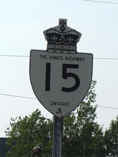
Highway 15 was downloaded south
of Highway 401, it is now known as Frontenac/Kingston Road 15 |
| City of Kingston |
(Barriefield
By-pass) |
--- (0km) / --- (161.2km) |
Highway 2
(Frontenac/Kingston Road 2) |
| City of Kingston |
----- |
--- (6.2km) / --- (155.0km) |
Middle Road (Frontenac/Kingston Road 14) |
|
Current Southern Terminus of
Highway 15 is located at Highway 401 |
| City of Kingston |
----- |
0km (6.5km) / 113.4km ( 154.8km) |
King's
Highway 401 |
| City of Kingston |
Codes Corners |
1.3km (7.8km) / 112.0km (153.4km) |
Kingston Mills Road |
| City of Kingston |
Pine Hill |
7.5km (14.0km) / 105.9km
(147.3km) |
----- |
| City of Kingston |
Joyceville |
11.2km (17.7km) / 102.1km
(143.5km) |
Joyceville Road (Frontenac/Kingston Road 16) |
| City of Kingston |
----- |
13.4km (19.9km) / 99.9km
(141.3km) |
Sandhill Road (Frontenac/Kingston Road 13) |
| City of Kingston |
Washburn |
--- |
----- |
| City of Kingston |
Brewers Mills |
16.9km (23.4km) / 96.4km
(137.8km) |
Sunbury Road (Fronteac/Kingston Road 12) |
| Frontenac (Kingston) - Leeds & Grenville
(Leeds and the Thousand Islands) Boundary |
Kingston North Limits |
25.5km (32.0km) / 87.9km
(129.3km) |
----- |
| Township of Leeds and the Thousand Islands |
(Seeley's Bay
By-pass) |
26.2km (32.7km) / 87.1km
(128.5km) |
Leeds & Grenville Road 47 (Formerly Leeds &
Grenville Road 43)-South-jct |
| Township of Leeds and the Thousand Islands |
(Seeley's Bay
By-pass) |
28.4km (34.9km) / 85.0km
(126.4km) |
Leeds & Grenville Road 47 (Formerly Leeds &
Grenville Road 43)-North-jct |
| Township of Leeds and the Thousand Islands |
----- |
30.4km (36.9km) / 82.9km
(124.3km) |
Highway 32
(Leeds & Grenville Road 32) |
| Township of Leeds and the Thousand Islands |
----- |
31.5km (38.0km) / 81.8km
(123.2km) |
Lyndhurst Road (Leeds & Grenville Road 33) |
| Township of Rideau Lakes |
Morton |
--- |
----- |
| Township of Rideau Lakes |
----- |
37.0km (43.5km) / 76.4km
(123.2km) |
Jones Falls Road (Leeds & Grenville Road 11) |
| Township of Rideau Lakes |
The Bush |
--- |
----- |
| Township of Rideau Lakes |
(Elgin By-pass) |
44.9km (51.4km) / 68.5km
(109.9km) |
Main Street (Leeds & Grenville Road 8) |
| Township of Rideau Lakes |
----- |
48.6km (55.1km) / 64.8km
(106.2km) |
Chaffey's Lock Road (Leeds & Grenville Road 9) |
| Township of Rideau Lakes |
Crosby |
51.1km (57.6km) / 62.2km
(103.6km) |
Highway 42 (Leeds & Grenville Road 42) |
| Township of Rideau Lakes |
Portland |
--- |
----- |
| Township of Rideau Lakes |
----- |
65.9km (72.4km) / 47.0km (88.4km) |
Leeds & Grenville Road 5 |
| Township of Rideau Lakes |
----- |
66.7km (72.4km) / 46.6km (88.0km) |
Briton-Houghton Bay Road (Leeds & Grenville Road
38) |
| Township of Rideau Lakes |
Lombardy |
74.9km (81.4km) / 38.4km (79.8km) |
Rideau Ferry Road (Leeds & Grenville Road
1-North) |
| Township of Rideau Lakes |
Lombardy |
75.1km (81.6km) / 38.2km (79.6km) |
Anglican Church Road (Leeds & Grenville Road
1-South) |
| Leeds & Grenville (Rideau Lakes)- Lanark
(Smiths Falls) Boundary |
Smiths Falls South Limits |
82.7km (89.2km) / 30.7km (72.1km) |
----- |
|
At Highway 29 (Brockville
Street): NB: Turn Left onto Beckwith Street Street. SB: Turn
Right onto Lombard Street. |
| Town of Smiths Falls |
Smiths Falls |
85.1km (91.6km) / 28.2km (69.6km) |
Highway 29 (Brockville Street) & Jasper Avenue |
|
At Highway 43-East: NB:
Turn Left onto Elmsley Street. SB: Turn Right onto Beckwith Street
towards Highway 29. |
| Town of Smiths Falls |
Smiths Falls |
86.0km (92.5km) / 27.4km (68.8km) |
Highway 43-East (Elmsley Street-East) |
|
At Highway 43-West: NB:
Turn Right onto Cornelia Street. SB: Turn Left onto Elmsley Street. |
| Town of Smiths Falls |
Smiths Falls |
86.4km (92.9km) / 27.0km (68.4km) |
Highway 43-West (Cornelia Street) |
|
At Rover Stevens Drive: NB:
Turn Left onto Union Street. SB: Turn Right onto Cornelia Street. |
| Town of Smiths Falls |
Smiths Falls |
--- |
Roger Stevens Drive (To Lanark Road 4) |
| Smith Falls - Montague Boundary |
Smiths Falls North Limit |
87.3km (93.8km) / 26.0km (67.4km) |
----- |
| Township of Montague |
Numogate |
--- |
----- |
| Township of Beckwith |
Franktown |
101.6km (108.1km) / 11.7km
(53.1km) |
Perth Road (Lanark Road 10-West) |
| Township of Beckwith |
----- |
102.7km (109.2km) / 10.7km
(52.1km) |
Richmond Road (Lanark Road 10-East) |
|
Current Northern Terminus of
Highway 15 is located at Highway 7 |
|
Before downloading, at Highway
7-West: NB: Follow the ramp to the right onto Highway 7 East.
SB: Turn Left towards Smiths Falls. |
| Town of Carleton Place |
Carleton Place |
113.5km (119.8km) / 0km (41.4km) |
King's Highway 7-West |
|
At Highway 7-East: NB: Turn
Left onto McNeely Avenue. SB: Turn Right onto Highway 7 towards Perth. |
| Town of Carleton Place |
Carleton Place |
--- (120.5km) / --- (40.8km) |
King's Highway 7-East |
|
At Highway 7B: NB: Turn
Right onto Lanark Road 29. SB: Turn Left onto McNeely Avenue. |
| Town of Carleton Place |
Carleton Place |
--- (123.2km) / --- (38.0km) |
Highway 7B (Forced Road-West) |
|
Carleton Place North Limits:
North of Carleton Place, Highway 15 is now known as Lanark Road 29.
SB: Upon entering Carleton Place, Highway 15 is known as Forced Rd. |
| Town of Mississippi Mills |
Carleton Place North Limits |
--- (123.4km) / --- (37.8km) |
----- |
| Town of Mississippi Mills |
----- |
--- (125.3km) / --- (35.9km) |
Wilson Street (Lanark Road 11) |
| Town of Mississippi Mills |
(Former) Almonte South
Limits |
--- (132.2km) / --- (29.0km) |
----- |
| Town of Mississippi Mills |
Almonte |
--- (133.2km) / --- (28.0km) |
Highway 44 (Almonte Street) & Wolf Grove Road
(Lanark Road 16) |
| Town of Mississippi Mills |
(Former) Almonte North
Limits |
--- (134.3km) / --- (26.9km) |
----- |
| Town of Mississippi Mills |
Pakenham |
--- (148.5km) / --- (12.7km) |
Waba Road (Lanark Road 20-West) |
| Town of Mississippi Mills |
Pakenham |
--- (148.8km) / --- (12.4km) |
Kinburn Sideroad (Lanark Road 20-East) |
|
Lanark - Ottawa Boundary.
Highway 15 has been designated as County Road 29 in both jurisdictions. |
| Lanark (Mississippi Mills) - Ottawa Boundary |
----- |
--- (154.4km) / --- (6.9km) |
Shaw Road (Lanark Road 22) |
| City of Ottawa |
----- |
--- (155.4km) / --- (5.9km) |
Galetta Sideroad (Ottawa Road 22) |
| City of Ottawa |
----- |
*** |
King's Highway 417 |
| City of Ottawa |
----- |
*** |
Madawaska Drive (King's Highway 17) |
|
Highway 15 ENDS |