King's Highway 58A - www.OntHighways.com

Highway 58A is a short highway that connects Highway 58 to Highway 140 on the south side of Welland.  The highway passes underneath the Welland Canal via the Townline Tunnel, providing the southerly uninterrupted crossing of the seaway.  No portion of this highway was downloaded in the late 1990s.


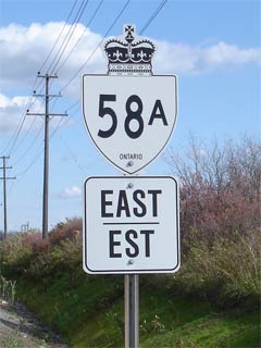
New Style Highway 58A shield

  Western Terminus:  Junction Highway 58 south of Welland

Eastern Terminus:  Junction Highway 140

Length:  4.9km

Multiplexes:  None

Freeway:  No

AADT (2002):  Highest:  6,250, from Canal Bank Street to Highway 140;

                             Lowest:  4,640, from Highway 58 to Canal Bank Street.

Road info:  Highway 58A was completely resurfaced and reconstructed during the summer of 2006 and is (unsurprisingly) now in excellent condition.  The short highway features fully paved shoulders for the entire length of the highway, and has a posted speed limit of 80km/h.


Highway 58A information:


OntHighways.com  

Detailed Route information available below
Virtual Tour of Highway 58A


TheKingsHighway.ca   History of Highway 58A
Photographic History of Highway 58A

Communities and Major Intersections located along Highway 58A from West to East:

Proper Municipality Name Community Name Distance Intersecting Road
City of Welland ----- 0km / 4.9km King's Highway 58/West Side Road (Niagara Road 54)
City of Welland ----- 0.7km / 4.2km Canal Bank Street

At Reaker Road:  EB: Turn Left on Reaker Road, and left again on Netherby Road towards Highway 140.  WB: Turn Right on Reaker Road, and right again at Niagara Road 525

City of Welland ----- 4.5km / 0.4km Townline Tunnel Road (Niagara Road 525)
City of Welland ----- 29.9km / 0km King's Highway 140
Highway 58A ENDS

<- Highway 58         www.OntHighways.com - Home         Highway 59 ->


Copyright (c) 2004-2010, AsphaltPlanet.ca  AsphaltPlanet@asphaltplanet.ca

Page last updated:  October 21st, 2006

Page created:  October 21st, 2006