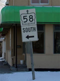
King's Highway 58 - www.OntHighways.com

Highway 58 is a short but very important north-south highway that serves the Niagara Peninsula.  Before downloading the highway ran from Highway 3 in Port Colborne, northerly through Welland to Highway 406 in the north end of Thorold.  In 1997/98 Highway 58 was carved into two distinct segments, as the urban portion of Highway 58 through Welland was transferred to local authorities.  The transfer of the mid-section of Highway 58 is fairly sensible since its routing through Welland was redundant since being bypassed by Highways 140 and 406.


Oversized King's Highway 58 Crown

  Southern Terminus:  Junction Highway 3 in the west end of Port Colborne

Northern Terminus:  At the Highway 406 interchange in Thorold.

Discontinuity:  In 1997/98 Highway 58 was decommissioned from Highway 58A northerly, through Welland, to the eastern Highway 20 junction.  This resulted in a two distinct segments of Highway 58.

Length:  Pre 1998: 32.9 km.  Currently: 14.7 km

Multiplexes:  Currently there are no multiplexes along Highway 58.  Before downloading there was a 3.3 km multiplex with Highway 20, and a 3.7  km multiplex with Highway 406.

Freeway: Highway 58 is a freeway from Thorold Stone Road westerly (northerly) to the Highway 406 interchange

AADT (2002):  Highest: 25,700 from Collier Street westerly (northerly) to the Highway 406 interchange in Thorold;

                             Lowest:  6,200 from Highway 20 northerly to Beaverdams Road.

Road Info: All of the current length of Highway 58 is presently in good condition, with light to moderate traffic volumes.  The highways routing through Welland (downloaded in 1998) was very redundant, and as such, was a logical transfer.  Rural speed limits along Highway 58 are posted at 80km/h.


Highway 58 information:


OntHighways.com  

Detailed Route information available below
Virtual Tour of Highway 58


TheKingsHighway.ca   History of Highway 58
Photographic History of Highway 58

Intersections and Communities Located along Highway 58 from South to North:

Proper Municipality Name

Community Name Distance

Major Intersection

City of Port Colborne Port Colborne 0 km / 32. 9 km Highway 3 (Main Street, Niagara Road 3)
Port Colborne - Welland Boundary ----- 5.3 km / 27.6 km Forks Road (Niagara Road 23)
City of Welland ----- 6.9 km / 26.0 km King's Highway 58A

Discontinuity: 18.2 km of Highway 58 was downloaded in 1998 between Highway 58A and Highway 20.

North of Highway 58A, Highway 58 is now known as Niagara Road 54.

City of Welland Welland 8.6 km / 24.7 km Ontario Road (Niagara Road 31)
City of Welland Welland 9.4 km / 23.6 km Lincoln Street (Niagara Road 54)
City of Welland Welland 10.2 km / 22.8 km Main Street (Niagara Road 27)

At Thorold Road:  NB: Turn Right onto Thorold Road towards Highway 406.  SB: Turn left on Niagara Road 54 (Prince Charles Road) towards Port Colborne.

City of Welland Welland 12.0 km / 20.1 km Thorold Road (Niagara Road 538) & Rice Road (Niagara Road 56)

At Niagara Street:  NB: Turn Left onto Niagara Street towards Highway 406.  SB: Turn Right onto Thorold Road towards Port Colborne.

City of Welland Welland 13.4 km / 19.6 km Niagara Street (Niagara Road 50-South)
City of Welland Welland --- Woodlawn Road (Niagara Road 41)

At the Merritt Road / Merritville Hwy Intersection:  NB: Follow the ramp to the right onto Merritt Road.  SB: Turn Left towards Port Colborne.

Welland - Thorold Boundary ----- 16.6 km / 16.2 km Merritville Road (Niagara Road 50-North)

At Highway 406-South:  NB: Turn Left at the traffic lights.  SB: Ramp to the right towards Welland.

City of Thorold ----- --- King's Highway 406-South
City of Thorold ----- 18.9 km / 14.1 km Port Robinson Road (Niagara Road 63)

At Highway 406-North:  NB: Ramp to the right towards Niagara Falls.  SB: Turn Left towards Welland.

City of Thorold ----- 21.8 km / 11.1 km King's Highway 406-North & Highway 20-West (Niagara Road 20)

Discontinuity Ends:  Highway 58 resumes at Highway 20 near Allenburg.

At Highway 20-East:  NB: Turn Left towards Thorold.  SB: Turn Right towards Hamilton and Welland.

City of Thorold ----- 25.2 km / 7.8 km King's Highway 20-East & Allenport Road (Niagara Road 82)
City of Thorold ----- --- Niagara Falls Road & Beaverdams Road

At Thorold Stone Road:  NB: Turn Left towards the Thorold Tunnel, and Highway 406.  SB: Ramp to the Right towards Highway 20.

City of Thorold ----- 29.4 km / 3.6 km Thorold Stone Road (Highway 7186, to Niagara Road 57)
City of Thorold Thorold 30.7 km / 2.2 km Pine Street
City of Thorold Thorold 21.5 km / 1.4 km Collier Street
City of Thorold Thorold 32.9 km / 0 km King's Highway 406 & St. David's Road (Niagara Road 71)
Highway 58 ENDS

<- Highway 56         www.OntHighways.com - Home         Highway 58A ->


Copyright (c) 2004-2010, AsphaltPlanet.ca  AsphaltPlanet@asphaltplanet.ca

Page last updated:  March 5th, 2007

Page created:  July 13th, 2004