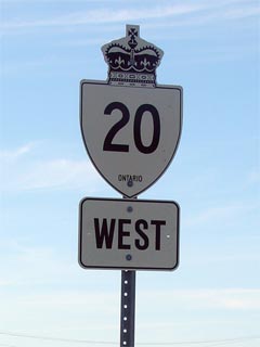
|
Proper
Municipality Name |
Community Name |
Distance |
Intersecting Road |
|
Highway 20 has been downloaded to
the City of Hamilton. It is known as Centennial Parkway between the
QEW and Elfrida, and County road 20 for the remaining section in Hamilton |
|
City of Hamilton |
Hamilton |
--- (0km) / --- (63.6km) |
Queen Elizabeth Way |
|
City of Hamilton |
Hamilton |
--- (0.8km) / --- (62.8km) |
Barton Street |
|
City of Hamilton |
(Former) Hamilton - Stoney Creek
Limits |
--- (1.9km) / --- (61.7km) |
Highway 8 (Queenston Road) |
|
City of Hamilton |
Stoney Creek |
--- (3.3km) / --- (60.3km) |
King Street |
|
Stoney Creek Mountain Access |
|
City of Hamilton |
Stoney Creek |
--- (5.0km) / --- (58.5km) |
Ridge Road |
|
City of Hamilton |
Stoney Creek |
--- (6.5km) / --- (57.1km) |
Mud Street (Formerly Hamilton Road 411) |
|
EB: Turn Left at Elfrida
(signed as County Road 20). WB: Turn Right onto Centennial
Parkway (no mention of Highway 20) |
|
City of Hamilton |
Elfrida |
--- (8.4km) / --- (55.2km) |
Highway 53 (Rymal Road) &
Highway 56 (Hamilton Road 56) |
|
City of Hamilton |
(Former) Stoney Creek
South Limits |
--- (11.2 km) / --- (52.4km) |
----- |
|
City of Hamilton |
----- |
--- (11.6km) / --- (51.9km) |
Tapleytown Road (Formerly Hamilton Road 434) |
|
City of Hamilton |
----- |
--- (11.9km) / --- (51.7km) |
Woodburn Road (Formerly Hamilton Road 634) |
|
Hamilton-Niagara Boundary:
In Niagara, Highway 20 is now known as Niagara Road 20. In Hamilton,
Highway 20 is known as Hamilton Road 20. |
|
Township of West Lincoln |
Fulton |
--- |
----- |
|
Township of West Lincoln |
----- |
--- (18.2km) / --- (45.4km) |
Caistor Centre Road (Formerly Niagara Road 6) |
|
Township of West Lincoln |
----- |
--- (20.1km) / --- (43.5km) |
Grassie Road (Formerly Niagara Road 8) |
|
Township of West Lincoln |
Kimbo |
--- |
----- |
|
Township of West Lincoln |
----- |
--- (23.2km) / --- (40.4km) |
Grimsby Road (Niagara Road 12) |
|
Township of West Lincoln |
Smithville |
--- (26.9km) / --- (36.7km) |
Station Road (Niagara Road 14) |
|
Highway 20 has a small jog in
Smithville: EB: Turn right at Station Street, then left at the
traffic lights. WB: Turn Right at the traffic lights (the road
ends) and then turn left onto first street past (West Street) |
|
Township of West Lincoln |
Smithville |
--- (28.1km) / --- (33.6km) |
Griffin Street (South) (Niagara Road 614) |
|
Township of West Lincoln |
----- |
--- (30.0km) / --- (32.0km) |
Twenty Creek Road (Niagara Road 69) |
|
EB: Turn Left at the four
corners of Bismark WB: Take the ramp to the right, (which bypasses the
community) towards Smithville |
|
Township of West Lincoln |
Bismark |
--- (34.5km) / --- (29.1km) |
Silver Street (Niagara Road 65) & Wellandport Road (Niagara Road 27) |
|
West Lincoln - Pelham Boundary |
Phelham West Limits |
--- (42.7km) / --- (20.9km) |
Townline Road (Niagara Road 24) |
|
Town of Pelham |
----- |
--- (45.5km) / --- (18.1km) |
Balfour Road (Formerly Niagara Road 28) |
|
Town of Pelham |
----- |
--- (48.6km) / --- (15.0km) |
Effingham Street (Formerly Niagara Road 32) |
|
Town of Pelham |
Fonthill |
--- (49.9km) / --- (13.7km) |
Canboro Road (Niagara Road 63) |
|
Town of Pelham |
Fonthill |
--- (50.6km) / --- (13.2km) |
Pelham Street (Niagara Road 36) |
|
Town of Pelham |
----- |
--- (51.3km) / --- (12.3km) |
Rice Road (Niagara Road 54) |
|
Pelham - Thorold Boundary |
Pelham - Thorold Limits |
--- (51.5km) / --- (12.1km) |
----- |
|
City of Thorold |
Turner's Corners |
--- (52.3km) / --- (10.7km) |
Merittville Road (Niagara Road 50) |
|
City of Thorold |
----- |
--- (54.2km) / --- (9.3km) |
King's Highway 406 &
Highway 58-South |
|
City of Thorold |
Allenburg |
--- |
----- |
|
Current Western Terminus of
Highway 20 is located at Highway 58-North |
|
City of Thorold |
Black Horse Corner |
0km (57.6km) / 1.9km (6.0km) |
King's Highway 58-North & Allanport Road
(Niagara Road 82) |
|
Thorold - Niagara Falls Townline |
Thorold - Niagara Falls Limits |
1.9km (59.4km) / 0km (4.1km) |
Townline Road (Niagara Road 70) |
|
Current Western Terminus of
Highway 20 is located at Highway 58-North |
|
East of Townline Road, Highway 20
is once again known as Niagara Road 20 |
|
City of Niagara Falls |
Niagara Falls |
--- |
Kalar Road |
|
City of Niagara Falls |
Niagara Falls |
--- (63.5km) / --- (0.1km) |
Beverdams Road (Niagara Road 53) |
|
City of Niagara Falls |
Niagara Falls |
--- (63.6km) / --- (0km) |
Montrose Road (Niagara Road 98) |
|
Highway 20 officially ended at Montrose Road
(Niagara Road 98), originally 20 continued into Niagara Falls, but was
truncated here in an earlier bout of downloading
|
