Highway 59 is a north-south highway that
runs primarily through Oxford County, between Long Point, on the Lake Erie
shoreline northerly to Shakespeare, east of Stratford on Highway 7/8.
Highway 59 was transferred to the local municipalities that it ran through in
its entirety in 1998. Highway 59 is now known as Norfolk Highway 59,
Highway 3, Oxford Road 59, and (logically) Perth Road 107.
|
Proper Municipality
Name |
Community
Name |
Distance |
Major Intersection |
|
In Norfolk County, Highway 59 is now signed as Norfolk Highway 59. |
| County of Norfolk |
----- |
--- (0km) / --- (122.8km) |
End of Highway |
| County of Norfolk |
Long Point |
--- |
----- |
| County of Norfolk |
----- |
--- (8.0km) / --- (114.8km) |
Norfolk Road 42 |
| County of Norfolk |
----- |
--- (1-.7km) / --- (112.1km) |
Norfolk Road 22 |
| County of Norfolk |
----- |
--- (16.4km) / --- (106.4km) |
Highway 24 (Norfolk Road 24) / Norfolk Road 60 |
| County of Norfolk |
Walsingham |
--- |
----- |
| County of Norfolk |
----- |
--- (21.9km) / --- (100.9km) |
Norfolk Road 45 |
| County of Norfolk |
----- |
--- (24.6km) / --- (98.2km) |
Norfolk Road 1 |
| County of Norfolk |
Langton |
--- |
----- |
| County of Norfolk |
Andys Corners |
--- (28.8km) / --- (94.0km) |
Norfolk Road 21 |
| County of Norfolk |
----- |
--- |
----- |
| County of Norfolk |
Ronson |
--- (37.8km) / --- (85.0km) |
Norfolk Road 38-South |
|
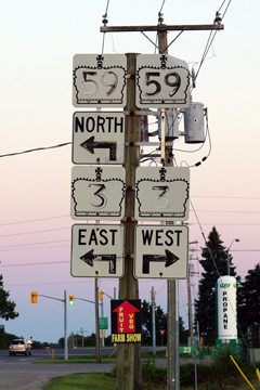
At Highway 3 West: NB: Follow the ramp to the
right along Highway 3 East. SB: Turn left at traffic signals towards
Long Point |
| County of Norfolk |
Courtland |
--- (39.1km) / --- (83.7km) |
King's Highway 3-West |
| County of Norfolk |
Courtland |
--- (40.3km) / --- (82.5km) |
Norfolk Road 38-West |
| County of Norfolk |
----- |
--- (46.1km) / --- (76.7km) |
Norfolk Road 16 |
|
At Highway 3 East: NB: Turn left onto Norfolk Highway 59.
SB: Follow ramp towards Tillsonburg along Highway 3 |
| County of Norfolk |
----- |
--- (50.4km) / --- (72.4km) |
King's Highway 3-East |
|
Norfolk / Oxford County Boundary. In Oxford County, Highway 59
is known as Oxford Road 59. |
| Norfolk / Oxford County Boundary |
----- |
--- (54.1km) / --- (68.7km) |
----- |
| Township of Norwich |
Summerville |
--- |
----- |
| Township of Norwich |
----- |
--- (56.2km) / --- (66.6km) |
Oxford Road 37 |
| Township of Norwich |
Brown's Corners |
--- (61.0km) / --- (61.8km) |
Oxford Road 19 |
| Township of Norwich |
Norwhich |
--- (67.4km) / --- (55.4km) |
Oxford Road 18 |
| Township of Norwich |
----- |
--- (72.4km) / --- (50.4km) |
Oxford Road 14 |
| Township of Norwich |
Burgessville |
--- |
----- |
| Township of Norwich |
----- |
--- (79.7km) / --- (43.1km) |
Oxford Road 46 |
| Township of Norwich |
Holbrook |
--- (80l.0km) / --- (42.8km) |
Oxford Road 13 |
| Township of Norwich |
Curries |
--- (86.1km) / --- (36.7km) |
Oxford Road 40 |
| Norwich / Woodstock Boundary |
Woodstock South Limits |
--- (90.3km) / ---
(32.5km) |
----- |
| City of Woodstock |
Woodstock |
--- (90.6km) / --- (32.2km) |
King's Highway 401
(Autoroute M-C Freeway) |
| City of Woodstock |
Woodstock |
--- (91.9km) / --- (30.9km) |
Oxford Road 15 |
|
At Highway 2 East: NB: Turn left at traffic
signals in Downtown Woodstock. SB: Turn right at traffic signals
towards Highway 401 in Downtown Woodstock. |
| City of Woodstock |
Woodstock |
--- (93.2km) / --- (29.6km) |
Highway 2-East (Oxford Road 2, Dundas Street) |
|
|
| City of Woodstock |
Woodstock |
--- (94.2km) / ---
(28.4km) |
Highway 2-West (Oxford Road 2, Vansittart
Street) |
| Woodstock / East Zorra - Tavistock
Boundary |
Woodstock North Limits |
--- (96.2km) / ---
(26.6km) |
----- |
| Township of East Zorra - Tavistock |
----- |
--- (96.3km) / ---
(26.5km) |
Oxford Road 48 |
| Township of East Zorra - Tavistock |
Tollgate |
--- (97.8km) / ---
(25.0km) |
Oxford Road 17 |
| Township of East Zorra - Tavistock |
Willow Lake |
----- |
----- |
| Township of East Zorra - Tavistock |
----- |
--- (100.8km) /
--- (22.0km) |
Oxford Road 33 |
| Township of East Zorra - Tavistock |
Huntingford |
----- |
----- |
| Township of East Zorra - Tavistock |
----- |
--- (107.1km) / --- (15.7km) |
Oxford Road 8 |
| Township of East Zorra - Tavistock |
----- |
--- (113.2km) / --- (9.6km) |
Oxford Road 28 |
| Township of East Zorra - Tavistock |
----- |
--- (115.3km) / --- (7.5km) |
Oxford Road 34 |
| Township of East Zorra - Tavistock |
----- |
--- (117.1km) /
--- (5.7km) |
Oxford Road 24 (William Street) |
| Township of East Zorra - Tavistock |
Tavsitock |
--- (118.2km) / --- (4.6km) |
----- |
|
Oxford / Perth County Boundary. Perth County has integrated
the former Highway 59 into the counties numbering grid and has as such
designated Highway 59 as Perth Road 107. |
| Township of Perth East |
----- |
--- (120.4km) / --- (2.4km) |
Perth Road 33 |
| Township of Perth East |
Shakespeare |
--- (122.8km) / --- (0.0km) |
King's Highway 7/8 |
|
Highway 59 ENDS |