New York Route 17
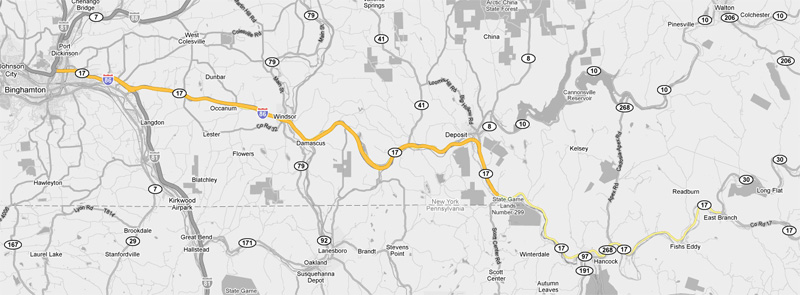
Binghamton to East Branch

<- Page 4 Page 6 ->

Pictures are arranged in order from west to east.  NY-17 East photos are left-aligned in the last column, while NY-17 West photos are right-aligned. 
Center-line pictures are centered within the last column.

Location

Description

Photo

East-
Bound

West-
Bound

Route 17 continues past Interstate 81 through Binghamton and Endicott westerly to Elmira and Corning.  Click here for Page 4 images.

Broome County
Village of Port of Dickinson

Westbound signage at the western I-81/NY-17 interchange.  The Western I-81/NY-17 interchange is situated atop of the Chenango River.

Photographed by: AsphaltPlanet.ca

Date: 7/12/2009

High Res

Broome County
Village of Port of Dickinson

Westbound diagram sign for the western I-81/NY-17 split.  Note that a distance is not shown on the diagram sign as to how far the sign is in front of the interchange.  Diagram signs in neighbouring Ontario often omit a distance as well.

Photographed by: AsphaltPlanet.ca

Date: 7/12/2009

High Res

Broome County
Village of Port of Dickinson

Westbound signage for the Route 7 interchange.  The right-most lane of an otherwise six-lane freeway becomes a collector lane for the cloverleaf interchange.  Route 7 is a short freeway that leads from the interstate into Downtown Binghamton.

Photographed by: AsphaltPlanet.ca

Date: 7/12/2009

High Res

Broome County
Village of Port of Dickinson

Westbound signage in advance of the Route 7 interchange that is unfortunately located behind a light-standard.

Photographed by: AsphaltPlanet.ca

Date: 7/12/2009

High Res

Broome County
Village of Port of Dickinson

Westerly view as Route 17 and I-81 meet both Exit 3 and 4 and cross overtop of the Canadian Pacific Railway.

Photographed by: AsphaltPlanet.ca

Date: 7/12/2009

High Res

Broome County
Town of Kirkwood

Overhead changeable message sign found westbound along the I-81/NY-17 multiplex.

Photographed by: AsphaltPlanet.ca

Date: 7/12/2009

High Res

Broome County
Town of Kirkwood

Eastbound reassurance marker for the co-designation of Route 17 and Interstate 81 just outside of Binghamton.  This assembly is likely not too much longer for this world as the Interstate 86 designation is gradually extended easterly superseding the Route 17 designation.

Photographed by: AsphaltPlanet.ca

Date: 7/12/2009

Broome County
Town of Kirkwood

Westbound signage for the I-81 South interchange.  Route 17 meets I-81-South at a fairly large scale interchange.

Photographed by: AsphaltPlanet.ca

Date: 7/12/2009

High Res

Broome County
Town of Kirkwood

Exit signage one mile in advance of the I-81-South interchange.  It looks as if the signage for I-81 has been overlaid with a yellow tab drawing attention to the fact that the ramp to I-81-South is a left exit.  Notice the black on yellow border seems just a tad smaller than the white on green signage.

Photographed by: AsphaltPlanet.ca

Date: 7/12/2009

High Res

Broome County
Town of Kirkwood

First advanced signage for the I-81 interchange.

Photographed by: AsphaltPlanet.ca

Date: 7/12/2009

High Res

Broome County
Town of Sanford

This view looks westerly towards Binghamton from County Road 217.


Photographed by: AsphaltPlanet.ca

Date: 7/12/2009

High Res

Broome County
Town of Sanford

Easterly view looking up the long grade from the County Road 217 overpass.  The eastbound on-ramp from Co. Road 217 becomes a short truck climbing lane to divert slow trucks from the high-speed general purpose freeway lanes.


Photographed by: AsphaltPlanet.ca

Date: 7/12/2009

High Res

Broome County
Town of Sanford

Westerly view from Farm Road.

Photographed by: AsphaltPlanet.ca

Date: 7/12/2009

High Res

Broome County
Town of Sanford

Easterly view into the sun from Fox Farm Road.  Route 17 is very quick to climb into the hills of the Catskills east of Binghamton.

Photographed by: AsphaltPlanet.ca

Date: 7/12/2009

High Res

Broome County
Town of Sanford

Easterly view from just a short distance east of the Fox Farm Road overpass.  The eastbound passing lane ends in this picture.  Notice the zone-striping that is used to restrict vehicles from entering the climbing lane as it ends.  This type of striping is not common among most North American jurisdictions that I have travelled in, however it is used extensively in Quebec.


Photographed by: AsphaltPlanet.ca

Date: 7/12/2009

High Res

Broome County
Town of Windsor

View as Highway 17 progresses westerly through a large valley at Exit 78.

Photographed by: AsphaltPlanet.ca

Date: 7/12/2009

High Res

Broome County
Town of Windsor

This view looks westerly from just west of Exit 79.  Note the I-86 shield pictured.  (As of July 2009) this is the first westbound reassurance marker located along Route 17.  I-86 has been marked between Exit 79 and I-81 South since before the Summer of 2007.

Photographed by: AsphaltPlanet.ca

Date: 7/12/2009

High Res

Broome County
Town of Windsor

Guide signage at the Exit to Route 79.

Photographed by: AsphaltPlanet.ca

Date: 7/12/2009

High Res

Broome County
Town of Windsor

Advanced signage for the New York Route 79 interchange.  It is hard to see from the photograph, but this is button-copy signage.  Button copy signs are extremely rare along Route 17.

Photographed by: AsphaltPlanet.ca

Date: 7/12/2009

High Res

Broome County
Town of Windsor

Westerly view of Route 79 just past the Exit 80 interchange.  Notice the lone Route 17 shield in the photo.  Surprisingly, no specialty shield was ever made highlighting this section of Route 17's designation as the 'Quickway'.

Photographed by: AsphaltPlanet.ca

Date: 7/12/2009

High Res

Broome County
Town of Windsor

Easterly view along Route 17/Interstate 86 towards the Church Street and Water Street interchanges.  The interchanges are linked together due to their close proximity.

Photographed by: AsphaltPlanet.ca

Date: 7/12/2009

High Res

Broome County
Town of Windsor

Westerly view in advance of Exit 80.  While Route 17 is very beautiful in the Summer, I think it would be quite treacherous in the winter time.

Photographed by: AsphaltPlanet.ca

Date: 7/12/2009

High Res

Broome County
Town of Windsor

View looking west at a reversing curve as Route 17 descends into a large valley.

Photographed by: AsphaltPlanet.ca

Date: 7/12/2009

High Res

Broome County
Town of Sanford

Westerly view towards the Route 41 interchange.

Photographed by: AsphaltPlanet.ca

Date: 7/12/2009

High Res

Broome County
Town of Sanford

Advanced sign Easterly view along Route 17/Interstate 86 towards the Church Street and Water Street interchanges.  The interchanges are linked together due to their close proximity.

Photographed by: AsphaltPlanet.ca

Date: 7/12/2009

High Res

Broome County
Town of Sanford

Westerly view from the Oquaga Lake Road overpass. 


Photographed by: AsphaltPlanet.ca

Date: 7/12/2009

High Res

Broome County
Town of Sanford

Easterly view from Oquaga Lake Road.  It is too bad this photo is as back-lit as it is, the long curve at Deposit is particularly pleasant.


Photographed by: AsphaltPlanet.ca

Date: 7/12/2009

High Res

Delaware County
Town of Deposit

Advanced signage for Deposit.

Photographed by: AsphaltPlanet.ca

Date: 7/12/2009

High Res

Delaware County
Town of Deposit

Westerly view at mile marker 278.  This photo was an attempt to show an at-grade intersection along the expressway.  Route 17 is a freeway for most of the highway's length with intermittent at-grade sections spread sporadically along the route between Elmira and Monticello.

Photographed by: AsphaltPlanet.ca

Date: 7/12/2009

High Res

Delaware County
Town of Deposit

Another westerly view of Route 17 through Hale Eddy.

Photographed by: AsphaltPlanet.ca

Date: 7/12/2009

High Res

Delaware County
Town of Deposit

Not only do minor roadways intersect Route 17 at-grade in sections, but during these at-grade segments, limited driveway access has been permitted.

Photographed by: AsphaltPlanet.ca

Date: 7/12/2009

High Res

Delaware County
Town of Hancock

View looking westerly at the exit to Hancock.

Photographed by: AsphaltPlanet.ca

Date: 7/12/2009

High Res

 Delaware County
Town of Hancock

Exit to Fish's Eddy.  At various places within a few miles of Fish's Eddy, Route 17 literally hovers overtop of the East Branch of the Delaware River on an elevated structure.

Photographed by: AsphaltPlanet.ca

Date: 7/12/2009

High Res

Delaware County
Town of Hancock

Westerly view at Mile 269.

Photographed by: AsphaltPlanet.ca

Date: 7/12/2009

High Res

Route 17 continues southeasterly along the PA/NY boundary east through Monticello and Middleton.  Click here for Page 6 images.


<- Page 4          Back to Route 17 Index          Page 6 ->

NY Highways
Canhighways.com


© 2007-10, CanHighways.com.  All rights reserved.  All pictures used on this site are the property of the respective photographers, and are used by permission.  No picture may be used without the consent of the respective photographer.

Page Created: January 9, 2010.
Last Updated: January 9, 2010.