King's Highway
36 - www.OntHighways.com
Highway 36 is an important
highway, yet it is not a particularly useful route for distance travelers. It is instead, an
important access road which links areas from the south (particularly the GTA) to
Bobcaygeon, and the very well developed Kawartha Lakes Region. Highway 36
was downloaded in its entirety January 1st, 1998.
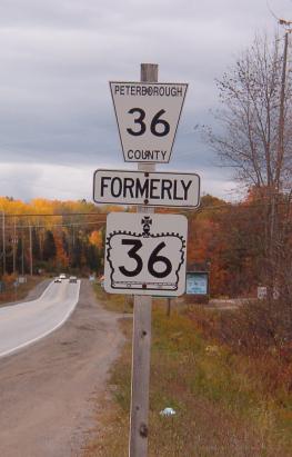
Formerly Highway 36 marker - Copyright Josh Anderchek
|
|
Western Terminus: Junction Highway 7
just southeast of Lindsay on the Bypass
Eastern Terminus: At Highway 28 in
Burleigh Falls
Length: 73.4 km
Multiplexes: A 7.3 km multiplex
existed with Highway 507 before both highways were downloaded in January
1998.
Freeway: No
Status: Entirely downloaded:
New names are Kawartha Lakes Road 36 and Peterborough Road 36
Road Condition: Highway 36 is very
nice for its entire length. The section in Kawartha Lakes was rehabilitated not too long before being downloaded
by the MTO. Peterborough County has refurbished its entire length of
36 since 1998 to very high standards as well.
The City of Kawartha Lakes seems to be doing its
best to ensure that Highway 36 does not remain the high MTO standard for long. |
Communities and Major Intersections along Highway 36 from West to East:
|
Proper Municipality Name |
Community Name |
Distance |
Intersection Name |
|
Highway 36 has been resigned
Kawartha Lakes Road 36 by the city of Kawartha Lakes |
| City of Kawartha Lakes |
----- |
0 km / 73.4 km |
King's Highway
7 (TCH Central Ontario Route) |
| City of Kawartha Lakes |
Lindsay |
3.3 km / 70.1 km |
Highway 36B (Queen Street) & Pigeon Lake Road
(Kawartha Lakes Road 17) |
| City of Kawartha Lakes |
Lindsay |
--- |
Colborne Street (Kawartha Lakes Road 17) |
| City of Kawartha Lakes |
----- |
14.1 km / 59.3 km |
Pleasant Point Road (Kawartha Lakes Road 11) |
| City of Kawartha Lakes |
Dunsford Bypass |
--- |
Sturgeon Road (Kawartha Lakes Road 7) |
| City of Kawartha Lakes |
----- |
--- |
Lakeshore Road (Kawartha Lakes Road 24) |
| City of Kawartha Lakes |
----- |
23.5 km / 49.9km |
(Scotch Line Road) |
| City of Kawartha Lakes |
----- |
--- |
Pigeon Lake Road (Kawartha Lakes Road 17) |
| City of Kawartha Lakes |
Bobcaygen |
--- |
King Street (Kawartha Lakes Road 4) |
|
Peterborough County has resigned
Highway 36 to Peterborough Road 36 |
| City of Kawartha Lakes |
Bobcaygen |
36.5 km / 36.9 km |
Main Street (Kawartha Lakes Road 8) & Highway
649 (Kawartha Lakes Road 49) |
|
In Bobcaygen turn right to stay
on 36 if EB, WB turn left towards Lindsay to stay on 36 |
| Township of Galway- Cavendish & Harvey |
Nogies Creek |
--- |
----- |
| Township of Galway- Cavendish & Harvey |
Flynns Turn |
52.6 km / 20.8 km |
Highway 507_North (Peterborough Road 507).
(Before 1998, 7.3 km multiplex with Highway 507). |
|
EB: Turn left in Buckhorn
to stay on Highway 36. EB: Turn Right |
| Township of Galway- Cavendish & Harvey |
Buckhorn |
59.9 km / 13.5 km |
Highway 507_South (Peterborough Road 23).
(Multiplex with Highway 507 Ends) |
| Township of Galway- Cavendish & Harvey |
Burleigh Falls |
73.4 km / 0 km |
King's Highway 28 |
|
Highway 36 ENDS |
<-
Highway 35B
www.OntHighways.com -
Home
Highway 37 ->
Copyright (c) 2004-2014, AsphaltPlanet.ca
AsphaltPlanet@asphaltplanet.ca
Page last updated: November 10th, 2004
Page created: March 14th, 2004