King's Highway 11 -  www.OntHighways.com

 Page 5   -   Nipigon to Rainy River

This stretch of Highway 11 runs the distance across the Southern part of Northwestern Ontario.  The route traverses some of the most populated areas of Northwestern Ontario (the Thunder Bay area), as well as some of the least populated areas (between Shabaqua and Fort Frances).  Notable centres along this stretch of highway include: Nipigon, Thunder Bay, Kakabeka Falls, Atikokan, Fort Frances, and Rainy River.


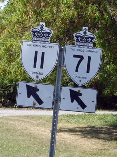
Highway 11/71 shields in Fort Frances.


Highway 11 Information that Pertains to the Shabaqua to Rainy River Section:

Multiplexes:   180.1 with Highway 17 from Nipigon to Shabaqua, 40.1km with Highway 71 west of Fort Frances, 2.0km with Highway 611 and finally for 1.8km with Highway 802.

Freeway:  None, however the Thunder Bay Expressway, is an at-grade urban expressway

Trans-Canada Highway:  Concurrent with Highway 17 Highway 11 is part of the Trans-Canada Highway network as part of the Lake Superior Route.  Until recently, Highway 11 was part of the Voyager Route which extended westerly from Shabaqua Corners to the western Highway 71 junction.  However despite being indicated on road maps, this routing of the Trans-Canada Highway is no longer signed in the field.

AADT (2002):  Highest: 20,900, from the Harbour Expressway to Highway 61 along the Thunder Bay Expressway;

                             Lowest: 710, from Highway 633 easterly to the Kashabowie River Bridge.

Road Info:  Between Shabaqua Corners and Nipigon, Highway 11 is in for the most part, very good condition.  A few short sections east of Thunder Bay are in need of attention, but the MTO is planning to make the necessary repairs.  West of Shabaqua, there are several sections of Highway 11 where the pavement condition is very deteriorated.  Fortunately again, the MTO plans to repair these stretches in the next few years as well.  Highway 11 has a rural posted speed limit of 90km/h through this section. .


Communities and Major Intersections along this section of Highway 11 from EAST to WEST:

Proper Municipality Name Community Name Distance Intersecting Road

At Highway 17-South:  WB: Continued from Page 4.  EB: Turn Left to Continue on Page 4

Township of Nipigon ----- 1,329.2 km / 554.3 km King's Highway 17-South
Township of Nipigon Nipigon --- First Street
Township of Nipigon Nipigon (1,333.2km) / (550.3km) Secondary Highway 585
Township of Red Rock ----- (1,341.7km) / (541.8km) Secondary Highway 628
District of Thunder Bay ----- (1,357.1km) / (526.4km) Secondary Highway 582 (East Jct.)
District of Thunder Bay ----- (1,361.4km) / (522.1km) Secondary Highway 582 (West Jct.)
Township of Dorion Dorion --- -----
Township of Shuniah ----- (1,397.7km) / (485.8km) Secondary Highway 587
Township of Shuniah ----- (1,412.8km) / (470.7km) Lakeshore Drive
Township of Shuniah ----- (1,427.7km) / (455.8km) Secondary Highway 527 & Spruce River Road
Shuniah - Thunder Bay Boundary Thunder Bay East Limits (1,429.1km) / (454.4km) -----
City of Thunder Bay Thunder Bay By-pass (1,431.6km) / (451.9km) Highway 11B/17B (Hodder Avenue)
City of Thunder Bay Thunder Bay By-pass --- Balsam Street
City of Thunder Bay Thunder Bay By-pass (1,438.0km) / (445.5km) King's Highway 102 (Red River Road)
City of Thunder Bay Thunder Bay By-pass (1,442.5km) / (441.0km) Oliver Road
City of Thunder Bay Thunder Bay By-pass (1,444.1km) / (439.4km) Harbour Expressway

At Highway 61:  WB: Follow the ramp to the right towards Kakabeka Falls.  EB: Turn Left onto the Thunder Bay Expressway.

City of Thunder Bay Thunder Bay (1,447.1km) / (436.4km) Highway 11B/17B (Aurthur Street) & King's Highway 61
Thunder Bay - Oliver Paipoonge Boundary Thunder Bay West Limits (1,453.5km) / (430.0km) -----
Township of Oliver Paipoonge ----- (1,455.7km) / (427.8km) King's Highway 130
Township of Oliver Paipoonge ----- (1,467.0km) / (416.5km) Secondary Highway 588
Township of Oliver Paipoonge ----- (1,471.3km) / (412.2km) Oliver Road
Township of Oliver Paipoonge Kakabeka Falls --- -----
Township of Oliver Paipoonge ----- (1,473.3km) / (410.2km) Secondary Highway 590
District of Thunder Bay Sistonen's Corners (1,498.4km) / (395. km) King's Highway 102
District of Thunder Bay ----- (1,498.0km) / (383.5km) Finmark Road

At Highway 17-East:  WB: Turn Left towards Fort Frances.  EB: Follow the ramp to the right towards Thunder Bay.

District of Thunder Bay Shabaqua Corner (1,509.3km) / (374.2km) King's Highway 17-West
District of Thunder Bay Shebandowan --- -----
District of Thunder Bay ----- (1,530.0km) / (353.5km) Secondary Highway 586
District of Thunder Bay ----- (1,553.5km) / (330.0km) Tertiary Road 802-North
District of Thunder Bay ----- (1,555.3km) / (328.2km) Tertiary Road 802-South
Thunder Bay - Rainy River Boundary ----- (1,592.4km) / (291.1km) -----
District of Rainy River ----- (1,614.9km) / (268.6km) Secondary Highway 633
District of Rainy River ----- (1,621.9km) / (261.6km) Secondary Highway 623
Township of Atikokan ----- (1,643.4km) / (240.1km) King's Highway 11B
District of Rainy River Mine Centre --- -----
District of Rainy River ----- (1,759.3km) / (124.2km) Secondary Highway 502
Fort Frances Boundary Fort Frances East Limits (1,786.1km) / (97.4km) -----
Town of Fort Frances Fort Frances (1,791.0km) / (92.5km) King's Highway 71-East (Central Avenue)
Town of Fort Frances Fort Frances (1,793.0km) / (90.5km) Highway 602 (Colonization Road)
Fort Frances - Alberton Boundary Fort Frances West Limits (1,795.0km) / (88.5km) -----
Township of Alberton ----- (1,800.2km) / (83.3km) Secondary Highway 611-South
Township of Alberton ----- (1,802.2km) / (81.3km) Secondary Highway 611-North
Township of La Vallee La Vallee --- -----
Township of La Vallee Devlin (1,812.1km) / (71.4km) Secondary Highway 613
Township of Emo Emo (1,824.8km) / (58.7km) Secondary Highway 602
District of Rainy River ----- (1,831.1km) / (52.4km) King's Highway 71-North
Township of Chapple Barwick --- -----
Township of Morley Stratton (1,850.1km) / (33.4km) Secondary Highway 617
Township of Dawson Pinewood (1,862.0km) / (21.5km) Secondary Highway 619
Township of Dawson Sleeman (1,871.6km) / (11.9km) Secondary Highway 621
Dawson - Rainy River Boundary Rainy River East Limits (1,880.5km) / (3.0km) -----
Town of Rainy River Rainy River (1,883.2km) / (0.3km) Highway 600
Ontario - Minnesota Boundary ----- (1,883.5km) / (0km) Minnesota Highway 11 via International Bridge

Highway 11 ENDS

Highway 11 (Page 5) - Images

Page 4 (Cochrane to Nipigon)

Highway 11 Home

www.OntHighways.com - Home


Copyright (c) 2004,2005 Scott Steeves (Webmaster)  webmaster@onthighways.com

Page last updated:  October 5th, 2006

Page created:  September 16th, 2006