King's Highway 17 -
O N T H I G H W A Y S
Page 1 -
Manitoba to Thunder Bay
Highway 17 is Northwestern
Ontario's major highway. It passes through some very nice scenery in the
Kenora and Dryden areas, however, there are many very flat and boring sections
of highway through this part of the province as well. Major centres located along Highway 17 in Northwestern Ontario
include: Kenora, Dryden, and Thunder Bay.
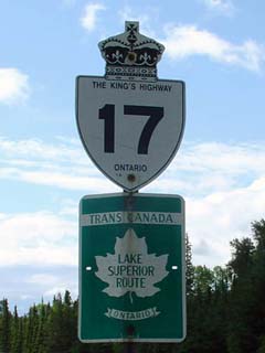
King's Highway 17 as the Trans-Canada Highway: Lake Superior Route
|
|
Highway 17 information that pertains to
the Manitoba to Thunder Bay Section:
Multiplexes: 180.1 km with Highway 11
from Shabaqua Corners through Thunder Bay to just east of Nipigon
Freeway: None. Highway 11/17 is an
at-grade urban expressway from Arthur Street (and Highway 61) to just east
of Hodder Street in the northeast end of Thunder Bay.
Trans-Canada Highway: Entire Length, as
the Lake
Superior Route
AADT
(2001): Highest: 7,150 from Highway 665 east to Dryden;
Lowest: 1,450 from Highway 17A (west jct) to 700m east of Highway 17A (west
jct).
Road Info: Coming Soon! |
Communities and Major Intersections along this section of Highway 17 from West to East:
|
Proper Municipality Name |
Community Name |
Distance |
Intersecting Road |
|
Highway 17 is continued from (or
continues as) Manitoba (TCH) Highway 1 |
| District of Kenora |
----- |
6.4 km / 2,129.7 km |
Secondary Highway 673 |
| District of Kenora |
Granite Lake |
--- |
----- |
| District of Kenora |
Clearwater Bay |
--- |
----- |
|
At Highway 17A (West JCT):
EB: Take the long ramp to the right to head into Kenora. WB:
Highway 17 meets Highway 17A at a 'T-junction' turn left to head towards
Winnipeg |
| District of Kenora |
----- |
39.9 km / 2,089.8 km |
King's Highway 17A |
| District of Kenora |
----- |
41.4 km / 2,088.3 km |
Secondary Highway 641 |
| City of Kenora |
Keewatin |
--- |
----- |
| City of Kenora |
Norman |
49.0 km / 2,080.7 km |
Highway 596 (Parsons Street) |
| City of Kenora |
Kenora |
52.1 km / 2,077.6 km |
Secondary Highway 658 |
| City of Kenora |
Kenora |
--- |
Park Street |
|
EB: In downtown
Kenora traffic must turn left from Main Street to Second Street to continue
east. WB: Turn Right from Second Street to Main Street to
continue west |
| City of Kenora |
Kenora |
53.5 km / 2,076.2 km |
Highway 604 (8th Ave) |
| City of Kenora |
Longbow Lake |
--- |
----- |
|
At Highway 17A (East JCT): EB:
Ramp to the right towards Highway 71, and Dryden. WB: Turn Left into
Kenora |
| District of Kenora |
----- |
69.0 km / 2,060,7 km |
King's Highway 17A |
| District of Kenora |
----- |
72.5 km / 2,057.2 km |
King's Highway 71 |
| District of Kenora |
Hawk Lake |
95.8 km / 2,033.9 km |
----- |
| District of Kenora |
Vermilion Bay |
144.7 km / 1,985.0 km |
Secondary Highway 647 |
| District of Kenora |
----- |
146.6 km / 1,983.1 km |
King's Highway 105 |
| District of Kenora |
----- |
160.9 km / 1,968.8 km |
Secondary Highway 594 (west jct) |
| District of Kenora |
Mannitaki |
--- |
----- |
| District of Kenora |
Oxdrift |
173.8 km / 1,955.9 km |
Secondary Highway 605 |
| District of Kenora |
(Two Mile Corner) |
185.0 km / 1,944.7 km |
Secondary Highway 665 |
| City of Dryden |
Dryden |
----- |
King Street |
| City of Dryden |
Dryden |
189.6 km / 1940.1 km |
Secondary Highway 601 (Colonization Road) |
| City of Dryden |
Dryden |
189.9 km / 1939.8 km |
Secondary Highway 594 (Duke Street) |
| District of Kenora |
----- |
194.4 km / 1935.2 km |
Secondary Highway 601 |
| District of Kenora |
Wabigooon |
--- |
----- |
| District of Kenora |
Dinoriwic |
216.7 km / 1,913.0 km |
King's Highway 72 |
| District of Kenora |
Borups Corners |
237.7 km / 1,892.0 km |
Secondary Highway 603 |
| District of Kenora |
----- |
261.3 km / 1,868.4 km |
Secondary Highway 622 |
| Township of Ignace |
Ignace |
--- |
----- |
| Township of Ignace |
----- |
296.4 km / 1,833.3 km |
Secondary Highway 599 |
| District of Kenora |
Martin |
--- |
----- |
| District of Thunder Bay |
English River |
351.2 km / 1,778.5 km |
----- |
| District of Thunder Bay |
Upsula |
--- |
----- |
| District of Thunder Bay |
Raith |
449.0 km / 1,680.7 km |
----- |
| District of Thunder Bay |
Shabaqua Corner |
474.0 km / 1,655.7 km |
King's Highway 11-West |
| District of Thunder Bay |
Sunshine |
--- |
----- |
| District of Thunder Bay |
Sistonen's Corners |
494.9 km / 1,634.8 km |
King's Highway 102 |
| District of Thunder Bay |
----- |
510.0 km / 1,619.7 km |
Secondary Highway 590 |
| District of Thunder Bay |
Kakabeka Falls |
--- |
----- |
| District of Thunder Bay |
----- |
516.3 km / 1,613.4 km |
Secondary Highway 588 |
| District of Thunder Bay |
----- |
527.6 km / 1,602.1 km |
King's Highway 130 |
|
EB: At the Thunder Bay
Expressway, turn left towards Nipigon. WB: At Aurhur Street turn right
towards to Kakabeka Falls to Stay on Highway 11/17 |
| City of Thunder Bay |
(Thunder Bay
Bypass) |
536.2 km / 1,593.5 km |
King's Highway 61 & Highway 11B/17B (Aurthur
Street) |
|
To Continue
Eastwards Along Highway 17 click
here |
Highway 17 (Page 1) - Images
Page 2 (Thunder Bay to Nipigon)
Highway 17 Home
O N T
H I G H W A Y S - Home
Copyright (c) 2004,2005 Scott Steeves (Webmaster)
webmaster@onthighways.com
Page last updated: January 13th, 2005
Page created: December 10th, 2004