|
New York Route 17 |
| <- Page 2 |
|
Page 4 -> |
Pictures are arranged in order from west to east. NY-17 East photos are
left-aligned in the last column, while NY-17 West photos are
right-aligned.
Center-line pictures are centered within the last column.
|
Location |
Description |
Photo |
||
|
East- |
West- |
|||
|
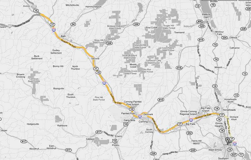
Route 17 continues west past bath towards Salamanca, Olean and Jamestown. Click here for Page 2 images. |
||||
| Route 390 continues northerly from Bath towards the New York State Thruway and Rochester. I-390 is the principal route from the Southern Tier into both Rochester and Buffalo. Click here for I-390 images. | ||||
|
Steuben County |
|
|
||
|
Date: 7/12/2009 |
||||
|
Steuben County |
|
|
||
|
Date: 7/12/2009 |
||||
|
Steuben County |
Easterly view along I-86 as drivers approach the exit to Coopers Plain New York. |
|||
|
|
||||
|
Date: 4/19/2009 |
||||
| US Route 15 begins southerly at I-86 continuing through Gang Mills and into Pennsylvania. Click here for US-15 images. | ||||
|
Steuben County |
|
 |
||
|
Date: 7/12/2009 |
||||
|
Steuben County |
Eastbound advanced signage for the ramp to Route 352 from the Route 15 interchange. |
|
||
|
Date: 4/19/2009 |
||||
|
Steuben County |
The eastbound exit to Route 352 departs from both the mainline alignment of Interstate 86, and the ramp from US-15 north to I-86 East. |
|
||
|
Date: 4/19/2009 |
||||
|
Steuben County |
|
 |
||
|
Date: 7/12/2009 |
||||
|
Steuben County Town of Erwin |
|
|
||
|
Date: 7/12/2009 |
||||
|
Steuben County |
Overhead exit sign for NY 417 (Exit 44 B) on I-86 West. The lengthy exit ramp diverges from the mainline freeway just prior to the NY 352 interchange, and straddles the mainline freeway for a distance until arriving at a signalized intersection with NY 417 (former US 15) amidst the new semi-directional "Y" interchange that marks US 15's Northern Terminus at I-86. |
|
||
|
Photographer: Dan Garnell |
Date: 8/03/2009 |
|||
|
Steuben County |
|
 |
||
|
Date: 7/12/2009 |
||||
|
Steuben County |
|
 |
||
|
Date: 7/12/2009 |
||||
|
Steuben County |
|
 |
||
|
Date: 7/12/2009 |
||||
|
Chemung County |
Westerly view along I-86 from the East Avenue overpass in Elmira. Prior to 2008, this section of the Southern Tier Expressway was only designated as Route 17. The Interstate 86 designation was pushed easterly when the traffic signals between Route 14 and Route 13 were eliminated. The interstate 86 designation continues a few miles east of East Avenue to the Brant Road at-grade intersection. |
|
||
|
Date: 4/19/2009 |
||||
|
Chemung County |
Easterly view along Route 17/Interstate 86 towards the Church Street and Water Street interchanges. The interchanges are linked together due to their close proximity. |
|
||
|
Date: 4/19/2009 |
||||
| Route 352 meets the Southern Tier Expressway at a double diamond interchange in Eastern Elmira. Route 352 is the principal state route through Elmira and Corning. Click here for Route 352 images. | ||||
|
Chemung County |
Two views from the eastern ridge surrounding the City of Elmira. Elmira has a population of roughly 30,000 residents, and is situated along the Chemung River. Residents have slowly been fleeing scenic Elmira as heavy manufacturing and the railway industry have slowly declined in the area. Elmira was first settled as an important transportation hub within the Southern Tier of the State. |
 |
||
|
|
||||
|
Date: 4/19/2009 |
||||
|
Route 17 continues easterly along the PA border past Elmira into Binghamton. Click here for Page 4 images. |
||||
<- Page 2 Back to Route 17 Index Page 4 ->
© 2007-10, CanHighways.com. All rights reserved. All pictures used on this site are the
property of the respective photographers, and are used by permission. No
picture may be used without the consent of the respective photographer.
Page Created: January 1, 2010.
Last Updated: January 1, 2010.


