Secondary Highway 653 - www.OntHighways.com

Highway 653 was downloaded to the County of Renfrew in 1998.  This short former secondary highway serves to lead traffic from Highway 17 northwest of Renfrew into Québec, continuing northerly as Québec Route 301.


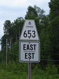
Secondary Highway 653 Shield

  Western Terminus: Junction King's Highway 17 and Renfrew Road 61 east of Haley Station

Eastern Terminus:  Québec Route 301, Ontario / Québec Boundary.

Length:  8.8km.

Multiplexes:  None

Orientation: East-West

Regions Served: Renfrew County

AADT (1994):  Highest: 1,950, from Renfrew Road 4 (Chenaux) to the Ontario / Québec Border;

                             Lowest:  950, from Highway 17 to Renfrew Road 4 (Chenaux).

Status:  Totally downloaded.  Highway 653 is now known as Renfrew Road 653.

Road Info:  Highway 653 is a very good highway.  It has been recently (as of 2011) resurfaced, is still well signed, and is built to near king's highway standards.


Highway 653 information:


OntHighways.com  

Detailed Route information available below
Virtual Tour of Highway 653


Communities and Intersections along and Highway 653 from West to East:

Proper Municipality Name Community Name Distance Intersecting Road

Highway 653 is known as Renfrew Road 653

Township of Whitewater Region ----- --- (0km) / --- (8.8km) King's Highway 17
Township of Whitewater Region ----- --- (0.6km) / --- (8.2km) Renfrew Road 48 (Formerly Renfrew Road 7)
Township of Whitewater Region Chenaux --- (6.3km) / --- (2.5km) Renfrew Road 4 (Storyland Road & Queens Line)
Township of Whitewater Region ----- --- (8.8km) / --- (0km) Québec Route 301 (Cheneaux Interprovincial Bridge)
Highway 653 ENDS

<- Highway 652          www.OntHighways.com - Home          Highway 654 ->


Copyright (c) 2004-2007, Scott Steeves (Webmaster)  webmaster@onthighways.com

Page last updated:  June 13th, 2011

Page created:  June 13th, 2011