Secondary Highway 559 - www.OntHighways.com

Highway 559 is a short secondary highway that leads west Highway 69 to Killbear Provincial Park.  The highway serves several small communities, and is quite busy by secondary highway standards.  Because Highway 559 is busier then most secondary highways, it is built to a higher standard then most secondaries.


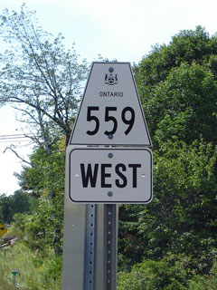
Secondary Highway 559 Shield

  Western Terminus:  Killbear Provincial Park

Eastern Terminus:  Junction Highway 69 just north of Nobel

Length:  19.6km

Multiplexes:  None

Multiplexes:  None

Orientation: East-West

Regions Served: Parry Sound District

AADT (2002):  Highest: 2,150, from Shebeshekong Road easterly to Highway 69;

                             Lowest:  1,150, from Killbear Provincial Park easterly to Dillon Road.

Road Info:  Highway 559 is in good condition for its entire length, with only the occasional rough patch.  The route is busy compared to other secondary highways, and as such the road is built to a good standard.  Highway 559 has a posted speed limit of 80km/h.


Highway 559 information:


OntHighways.com  

Detailed Route information available below
Virtual Tour of Highway 559


Communities and Intersections along and Highway 559 from West to East:

Proper Municipality Name Community Name Distance Intersecting Road
Township of Carling ----- 0km / 19.6 km Killbear Provincial Park Access Road
Township of Carling ----- --- Snug Harbour Road

At Dillon Road:  EB: Turn Right towards Highway 69.  WB: Turn Left towards Killbear Provincial Park

Township of Carling ----- 9.2km / 10.4km Dillon Road
Township of Carling Shebeshekong --- -----
Township of Carling ----- 17.3km / 2.3km Shebeshekong Road (Highway 7182)
Carling - McDougall Boundary ----- 19.6km / 0km King's Highway 69
Highway 559 Ends

<- Highway 558          www.OntHighways.com - Home          Highway 560 ->


Copyright (c) 2004-2007, Scott Steeves (Webmaster)  webmaster@onthighways.com

Page last updated:  May 23rd, 2006

Page created:  May 23rd, 2006