Secondary
Highway 534 - Secondary.OntHighways.com
Highway 534 runs to the south of
Lake Nipissing from Restoule Provincial Park easterly to Highway 11 at Powassan.
The route was not affected by provincial downloading.
Secondary Highway 534 Shield
|
|
Western Terminus: At Patterson Lake Road
in Restoule Provincial Park Eastern Terminus:
At the Highway 11 interchange located just west of Powassan.
Length: 44.0km
Multiplexes: None
Orientation: East-West
Regions Served: Parry Sound District
AADT (2002):
Highest: 840, from Highway 654 easterly to Highway 11;
Lowest:
220, from Patterson Lake Road easterly to Highway 524.
Road Info: Not available. |
Communities and Intersections along and Highway 534 from West to East:
|
Proper
Municipality Name |
Community Name |
Distance |
Intersecting
Road |
| District of Parry Sound |
----- |
0km / 44.0km |
Patterson Lake Road |
| District of Parry Sound |
Restoule |
9.0km / 35.0km |
Commanda Lake Road |
| District of Parry Sound |
Carr |
13.5km / 30.5km |
Secondary Highway 524 |
| Township of Nipissing |
Hotham |
--- |
----- |
| Township of Nipissing |
Nipissing |
30.7km / 13.3km |
Secondary Highway 654 |
| Township of Nipissing |
Christian Valley |
--- |
----- |
| Municipality of Powassan |
(Former) Powassan West
Limits |
41.6km / 2.4km |
----- |
| Municipality of Powassan |
Powasson |
44.0km / 0km |
King's
Highway 11 |
|
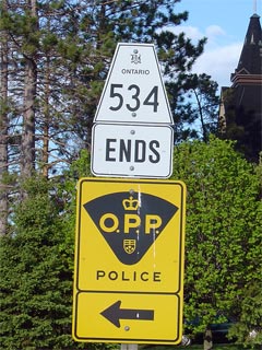
Highway 534 ENDS |
Highway 534 - Images
Secondary.OntHighways.com
- Home
www.OntHighways.com - Home
Copyright (c) 2004-2007, Scott Steeves (Webmaster)
webmaster@onthighways.com
Page last updated: May 17th, 2006
Page created: May 17th, 2006