AsphaltPlanet.ca >
OntHighways > Highway 420 > Images
< Hwy 417
Hwy 427 >
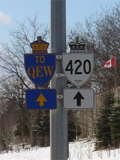
King's Highway 420 - www.OntHighways.com
Highway 420 is a short route that leads from the
Queen Elizabeth Way easterly to both Downtown Niagara Falls, and the Rainbow
Bridge. Despite the fact that the Highway 420 designation first
materialized in the 1970s, Highway 420 is actually a very historic route.
Much of the highway is a former alignment of the Queen Elizabeth Way that was opened
years before the Fort Erie leg of the QEW was constructed. Recently,
Highway 420 underwent a major rehabilitation for much of its length. Part
of this project was done as a joint venture between the Province and the Region
of Niagara. Since this reconstruction, the portion of Highway 420 east of
Stanley Avenue is now under the jurisdiction of the Region of Niagara, and no
longer signed as a provincial highway. Despite this, this portion of road
is still considered a provincial highway, as there is a connecting link
agreement between the MTO and the Region of Niagara.
New Style Highway 420 Shield
|
|
Western
Terminus: Highway 420 ends at an at-grade intersection with Montrose
Avenue in Niagara Falls.
Eastern Terminus:
At the Rainbow Bridge Bridge Entrance.
Length: 4.6 km.
Multiplexes: None
Freeway: Highway 420 is a freeway from
Montrose Road easterly to Stanley Avenue in Niagara Falls
AADT (2002): Highest:
34,300 from Dorchester Road easterly to Drummond Road in Niagara Falls;
Lowest:
11,600 from Victoria Avenue to the Rainbow Bridge entrance.
Road Info: Before quite recently,
Highway 420 was in relatively poor shape for its entire length.
In the past few years however, most of Highway 420 has been extensively reconstructed, and is
now in excellent condition. Speed limits on the 420 range from
80km/h on the freeway section, to 60km/h where it is a conventional city
street. |
Table
with 4 columns shows Highway 420 information when it is a conventional city
street. Table with 5 columns shows Highway 420 information when it is a
freeway. Information is arranged from East to West:
|
Proper Municipality Name |
Community Name |
Distance |
Intersecting Road |
|
Proper
Municipality Name |
Distance |
Freeway
Interchange |
North / West
Control City |
South / East
Control City |
| City of Niagara Falls |
Niagara Falls |
0 km / 4.6 km |
Montrose Avenue (Niagara Road 98) |
|
City of Niagara Falls |
0.4 km / 4.2 km |
Queen Elizabeth Way |
Toronto |
Fort Erie |
|
City of Niagara Falls |
1.1 km / 3.5 km |
Dorchester Road |
City of
Niagara Falls
Population: 76,000 |
|
City of Niagara Falls |
2.5 km / 2.1 km |
Drummond Road |
|
At Stanley Street: EB: Freeway section ends.
WB: Freeway section begins. |
| City of Niagara Falls |
Niagara Falls |
3.1 km / 1.6 km |
Stanley Avenue (Niagara Road 102) |
| City of Niagara Falls |
Niagara Falls |
4.1 km / 0.6 km |
Victoria Avenue |
| City of Niagara Falls |
Niagara Falls |
4.6 km / 0 km |
Falls Avenue & Rainbow Bridge Entrance. |
|
Highway 420 Ends |
<- Highway 417
www.OntHighways.com - Home
Highway 427 ->
Copyright (c) 2004-2010, AsphaltPlanet.ca
AsphaltPlanet@asphaltplanet.ca
Page last updated: August 25th, 2005
Page created: February 27th, 2004