
AsphaltPlanet.ca > Quebec > Autoroute 10
|
Western Terminus: A 720 in Downtown Montreal.
Eastern Terminus: A-55 in Magog Regions: Agglomeration de Montreal, Ville de Longueuil, MRC de Rouville, MRC de la Haute-Yamaska, MRC de Missisquoi, MRC de Memphremagog Routing: A-10 begins from the Ville Marie Autoroute in Downtown Montreal. It heads east across the Champlain Bridge into the Eastern Townships of Quebec. The freeway ends at a trumpet interchange with A-55 between Magog and Sherbroke. Links:
|
Pictures on this page are arranged in order from west to east. A-10 East photos are left-aligned in the last column, while A-10 west photos are right-aligned. Center-line pictures are centered within the last column.
|
Location |
Description |
Photo |
||
|
East- |
West- |
|||
|
A-10 begins at an eastbound partial interchange with A-720. Click here for A-720 images. |
||||
|
Agglomeration de Montreal |
View of A-10 as it passes eastbound past Technoparc. The truss bridge seen in the photo is Pont Victoria, carrying Route 112/116 across the Saint Lawrence. |
|
||
|
Date: 12/7/2008 |
High-res | |||
|
Ville de Longueuil |
View driving east across the Champlain Bridge |
 |
||
|
Date: 12/7/2008 |
High-res | |||
|
Ville de Longueuil |
Pont Champlain has a six lane cross-section. During rush periods the left most lane in the non-rush direction carries opposing transit vehicles (!) -- Fortunately for tourists, signs explaining the phenomena are written in both French and English. |
 |
||
|
Date: 12/7/2008 |
High-res | |||
|
Ville de Longueuil |
Over the ship channel the Champlain Bridge is an elegant steel truss bridge. |
|
||
|
Date: 12/7/2008 |
High-res | |||
|
Ville de Longueuil |
View through the truss bridge onto the South Shore. |
 |
||
|
Date: 12/7/2008 |
High-res | |||
|
Ville de Longueuil |
Overhead signage in advance of the A-15/20 interchange. A-15 heads to the right towards New York State. A-20 heads to the left towards Quebec City. |
|
||
|
Date: 12/7/2008 |
High-res | |||
|
Ville de Longueuil |
Second of three overhead signs for A-15 and A-20. |
 |
||
|
Date: 12/7/2008 |
High-res | |||
|
Ville de Longueuil |
All through traffic along A-20 and A-15 must navigate this tight loop ramp. Considering these are both long distance principal though routes both leading through the heart of Montreal, it is no wonder the MTQ has been so aggressive to finish the South Shore Bypass (A-30). |
 |
||
|
Date: 12/7/2008 |
High-res | |||
|
At the eastern end of Pont Champlain, A-10 intersects with A-15 and A-20. Click here for A-15 images, and here for A-20 images. |
||||
|
Ville de Longueuil |
View looking westerly at the ramp to Autoroute 15 South and Autoroute 20 East. Straight ahead, Autoroute 10 crosses the Champlain Bridge onto Montreal Island. |
 |
||
|
Date: 5/24/2015 |
High-res: (1440x960) (2400x1600) | |||
|
Ville de Longueuil |
Westbound advanced signage for the ramp to Autoroute 15 South and Autoroute 20 East. |
 |
||
|
Date: 5/24/2015 |
High-res: (1440x960) (2400x1600) | |||
|
Ville de Longueuil |
Overhead advanced sign for Route 134. |
 |
||
|
Date: 12/7/2008 |
High-res | |||
|
Ville de Longueuil |
Two westerly views from the Boulevard Pelletier Overpass. Note the end of the contraflow transit lanes and the newly constructed transit carriageway. Montreal has a very extensive mass transit network. |
 |
||
| High-res | ||||
 |
||||
|
Date: 12/7/2008 |
||||
|
Ville de Longueuil |
Easterly view from the Boulevard Pelletier overpass towards the Route 134 interchange. The R-134 interchange was reconfigured during 2007. |
 |
||
|
Date: 12/7/2008 |
||||
|
Ville de Longueuil |
This overhead signage is situated directly adjacent to the Boulevard Pelletier overpass. The signage explains the contraflow transit lane that exists during rush hours along the Champlain Bridge. During the afternoon peak, there are only two Montreal-bound general purpose lanes across the Champlain Bridge, as busses run towards the South Shore in the left-most lane. |
 |
||
|
Date: 5/24/2015 |
High-res: (1440x960) (2400x1600) | |||
|
Ville de Longueuil |
Westbound advanced sigange for the Autoroute 15/20 interchange situated byond the interchange for Boulevard Taschereau (Route 134) |
 |
||
|
Date: 5/24/2015 |
High-res: (1440x960) (2400x1600) | |||
|
Ville de Longueuil |
Westbound signage at the off-ramp to Boulevard Tashereau (Route 134). |
 |
||
|
Date: 5/24/2015 |
High-res: (1440x960) (2400x1600) | |||
|
Ville de Longueuil |
Advanced signage for the Boulevard Taschereau interchange. The left-most lane on the freeway is reserved exclusively for buses. |
 |
||
|
Date: 5/24/2015 |
High-res: (1440x960) (2400x1600) | |||
|
Ville de Longueuil |
Beyond the Autoroute 30 interchange stands this advanced signage for the Boulevard Taschereau interchange. |
 |
||
|
Date: 5/24/2015 |
High-res: (1440x960) (2400x1600) | |||
|
A-10 intersects A-30 at a cloverleaf interchange south of Longueuil. Click here for A-30 images. |
||||
|
MRC de la Vallee-du-Richelieu Carignan |
Overhead signage at the ramp to the cloverleaf interchange that links Autoroute 30 to Autoroute 10. |
 |
||
|
Date: 9/18/2011 |
High-res: (1440x960) (2400x1600) | |||
|
MRC de la Vallee-du-Richelieu Carignan |
Advanced signage for the Autoroute 30 cloverleaf. Autoroute 25, accessible to the east along A-30, is a useful alternate for traffic bound for destinations north and east of Downtown. |
 |
||
|
Date: 9/18/2011 |
High-res: (1440x960) (2400x1600) | |||
|
MRC de la Vallee-du-Richelieu Carignan |
2km advanced signage for the Autoroute 30 interchange. Traffic bound for New York State is directed to follow Autoroute 30 West towards Autoroute 15 and Interstate 87. |
 |
||
|
Date: 9/18/2011 |
High-res: (1440x960) (2400x1600) | |||
|
MRC de la Vallee-du-Richelieu Carignan |
3km advanced sign for the Autoroute 30 interchange. |
 |
||
|
Date: 9/18/2011 |
High-res: (1440x960) | |||
|
MRC de la Vallee-du-Richelieu Carignan |
Clearview signage detailing the exits that lead to the USA from A-10. |
 |
||
|
Date: 7/16/2009 |
High-res | |||
|
MRC de la Vallee-du-Richelieu Carignan |
Overhead signage for Autoroute 35. Autoroute 35 is a short freeway that links Route 133 to A-10. During the next few years (this page was authored in 2009), A-35 will be extended further southerly to directly connect with Interstate-89 in Vermont. |
 |
||
|
Date: 7/16/2009 |
High-res | |||
|
A-35 leads southerly from A-10 towards St-Jean-sur-Richelieu and the US border. Click here for A-35 images. |
||||
|
MRC de la Vallee-du-Richelieu Chambly |
Signage at the ramp to A-35 from A-10 West. Despite being a freeway to freeway movement, traffic heading west along A-10 bound for A-35 South must turn left at a traffic light at the end of this ramp. |
 |
||
|
Date: 6/18/2013 |
High-res: (1440x960) (2400x1600) | |||
|
MRC de la Vallee-du-Richelieu Chambly |
Final westbound advanced signage for A-35. |
 |
||
|
Date: 6/18/2013 |
High-res: (1440x960) (2400x1600) | |||
|
MRC de la Vallee-du-Richelieu Chambly |
2km advanced signage for the A-35 interchange. |
 |
||
|
Date: 6/18/2013 |
High-res: (1440x960) (2400x1600) | |||
|
MRC de la Vallee-du-Richelieu Chambly |
3km advanced signage for the A-35 interchange. |
 |
||
|
Date: 6/18/2013 |
High-res: (1440x960) (2400x1600) | |||
|
MRC de Rouville Richelieu |
View looking west as Autoroute 10 crosses the Richelieu River. The structure that carries A-10 overtop of the river was extensively rehabilitated during the 2011 and 2012 construction seasons. |
 |
||
|
Date: 6/18/2013 |
High-res: (1440x960) (2400x1600) | |||
|
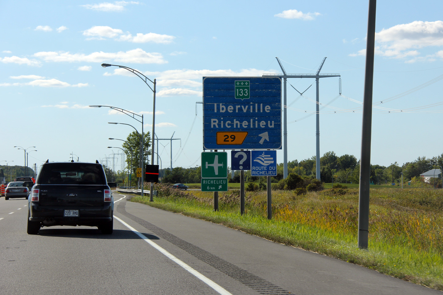
MRC de Rouville Richelieu |
Westbound exit signage for Highway 133. This blue signage is a relic from the days when Autoroute 10 was the Eastern Townships Toll Roads. |
 |
||
|
Date: 7/16/2009 |
High-res: (1440x960) | |||
|
MRC de Rouville Richelieu |
View looking westerly from the Rang de la Savane overpass just west of the Richelieu River. Notice the blue guide signage in the distance for the Route 133 interchange. Sporatic blue signage from the Days of the Eastern Townships Tollway remains between Montreal and Sherbrooke along A-10. |
 |
||
|
Date: 7/16/2009 |
||||
|
MRC de Rouville Richelieu |
View looking easterly from the Rang de la Savane overpass. Notice the hill in the distance standing tall above the otherwise Pancake flat Saint Lawrence Valley. |
 |
||
|
Date: 7/16/2009 |
||||
|
MRC de Rouville Richelieu |
Blue advanced signage for Highway 133 situated just before the Rang de la Savane overpass. |
 |
||
|
Date: 7/16/2009 |
High-res: (1440x960) (2400x1600) | |||
|
RC de Rouville Marieville |
New overpass in rural Quebec. On my visit to Quebec in 2009, I noticed several new overpasses -- Quebec has been aggressively replacing freeway structures since the collapse of an overpass on A-19 in Laval that killed five people, injuring six more. |
 |
||
|
Date: 7/16/2009 |
High-res | |||
|
MRC de Rouville Marieville |
Guide signage for the Route 227 interchange. |
|
||
|
Date: 7/16/2009 |
High-res | |||
|
MRC de Rouville Marieville |
The Route 227 overpass. A lot of Quebec's overpasses are very unique, in this case having steel supports . I have to hand it to the engineers in La Belle Province for not always building boring concrete slabs supported by concrete pillars. |
 |
||
|
Date: 7/16/2009 |
High-res: (1440x960) (2400x1600) | |||
|
MRC de Rouville Richelieu |
Westerly view along Autoroute 10 from the Route 227 overpass. |
 |
||
|
Date: 7/16/2009 |
High-res: (1440x960) (2400x1600) | |||
|
MRC de Rouville Richelieu |
Easterly view from the Route 227 overpass. Until 1985, a toll plaza existed at this location. This explains the folded diamond interchange that connects Autoroute 10 to Route 227 and vice versa. |
 |
||
|
Date: 7/16/2009 |
High-res: (1440x960) (2400x1600) | |||
|
MRC de Rouville Ange-Gardien |
The blue exit signage that appears along Autoroute 10 harkens back to the days of the tolled Eastern Township's Autoroute. These signs make me wonder if Ontario decided to sign Highway 407 with blue signs based on how Quebec signed its formerly tolled highways. |
 |
||
|
Date: 7/16/2009 |
High-res | |||
|
MRC de Rouville Ange-Gardien |
Exit signage for Route 235. Steve Alpert has additional photos of blue Autoroute signage on his A-10 page on Alps Roads. |
|
||
|
Date: 7/16/2009 |
||||
|
MRC de la Haute-Yamaska Saint-Alphonse |
Exit signage for Route 139. Note once again, the unique and aesthetically pleasing structure design that has been employed to carry Highway 139 overtop of Highway 10. |
|
||
|
Date: 7/16/2009 |
High-res | |||
|
MRC de Memphrémagog Magog |
Eastbound signage in advance of the ramp to Route 141. |
 |
||
|
Date: 10/03/2014 |
High-res: (1440x960) (2400x1600) | |||
|
MRC de Memphrémagog Magog |
Advanced signage for the ramp to Route 141. |
 |
||
|
Date: 10/03/2014 |
High-res: (1440x960) (2400x1600) | |||
|
MRC de Memphrémagog Magog |
Signage at the off-ramp to Route 141 bound for Orford. |
 |
||
|
Date: 10/03/2014 |
High-res: (1440x960) (2400x1600) | |||
|
MRC de Memphrémagog Magog |
Advanced signage for the ramp to A-55 South. |
 |
||
|
Date: 10/03/2014 |
High-res: (1440x960) (2400x1600) | |||
|
MRC de Memphrémagog Magog |
Advanced signage for the ramp to A-55 South. |
 |
||
|
Date: 10/03/2014 |
High-res: (1440x960) (2400x1600) | |||
|
MRC de Memphrémagog Magog |
View as the ramp to A-55 leaves the mainline lanes of A-10 East. Beyond this interchange A-10 and A-55 run concurrently for approximately 22km to Sherbrooke. |
 |
||
|
Date: 10/03/2014 |
High-res: (1440x960) (2400x1600) | |||
|
A-10 intersects A-55-South between Magog and Sherbrooke. Click here for A-55 images. |
||||
<- A-5
PQ Highways
A-13 ->
AsphaltPlanet.ca
© 2010-2016 AsphaltPlanet.ca.
AsphaltPlanet@asphaltplanet.ca
Page Created: January 18, 2016.
Last Updated: June 13, 2011


