Secondary Highway
630 -
O N T H I G H W A Y S
Highway 630 is a connector highway
that leads south of Highway 17 to the small community of Kiosk located in the
northern portion of Algonquin Park. Highway 630 has changed very little
since its inception into the highway network in the early 1960s, and was
unaffected by provincial downloading in the late 1990s.
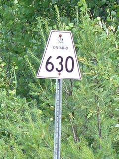
Secondary Highway 630 Shield
|
|
Southern Terminus: The small community
of Kiosk.
Northern Terminus: Junction Highway 17 west of Mattawa
Length: 27.8km
Multiplexes: None
Freeway: No
AADT (2002):
440, for the entire length of Highway 630
Road Info: Highway 630 ranges in
condition from excellent to poor along its journey from Highway 17 to Kiosk.
The southern portions of the highway are extremely lightly traveled, and
have not seen any major maintenance for decades. The southern portion of
highway has actually seen so little maintenance and traffic, that the
highway still features white centre lines. (Before the early 1970s,
Ontario painted centre-lines on roads with white paint as opposed to the
more traditional yellow). The northern stretches of Highway 630 are
more modern, and have in some cases been fairly recently rehabilitated.
Highway 630 has a posted speed limit of 80km/h. |
Communities and Intersections along and Highway 630 from South to
North:
|
Proper
Municipality Name |
Community Name |
Distance |
Intersecting
Road |
| District of Nipising |
Kiosk |
0 km / 27.8 km |
----- |
| Township of Calvin |
Blay's Corners |
16.7 km / 11.1 km |
----- |
| Township of Calvin |
Eau Claire |
--- |
----- |
| Township of Calvin |
Eau Claire Station |
--- |
----- |
| Township of Calvin |
----- |
27.8 km / 0 km |
King's Highway 17 |
|
Highway 630 Ends |
Highway 630 - Images
O N T
H I G H W A Y S - Home
Copyright (c) 2004-2006, Scott Steeves (Webmaster)
webmaster@onthighways.com
Page last updated: December 16th, 2005
Page created: December 16th, 2005