AsphaltPlanet.ca > OntHighways > Highway 410 >
Images
< Hwy 409
Hwy 416 >
King's Highway
410 - www.OntHighways.com
Highway 410 is a relative newcomer
to the 400-series highway network of Ontario. The highway stretches from
the Highway 401/403 interchange in northern Mississauga to Hurontario Street in
Caledon.
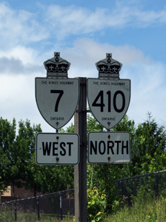
Highway 410 and Highway 7 Shield
|
|
Southern Terminus: At Highway
401/410 mega interchange in northern Mississauga
Northern Terminus: Highway 10/Hurontario
Street interchange in Caledon.
Length: 22.1 km
Multiplexes: Before downloading,
there was a 3.1km multiplex with Highway 7
Freeway: Entire Length. (11
interchanges)
AADT (2002):
Highest: 138,000, from Highway 401 northerly to Courtneypark Drive;
Lowest: 98,000, from Williams Parkway northerly to Bovaird Drive.
Road Info: Highway 410 is a very
busy highway. Its a fairly new freeway, and is well designed to carry
large volumes of traffic well. The 410 varies from six to eight lanes
through the older sections of highway through Brampton. The 2007, and
2009 highway extensions provide four freeway lanes, however these sections
were designed to easily be widened to six lanes when traffic volumes
warrant. A recently released travel times survey conducted by the MTO
found that Highway 410 in the southbound direction was the second slowest
highway in the GTA during the morning rush hour. Average speed drops
to approximately 38km/h. Average speed in 2006 was clocked at 71km/h,
nearly twice as fast as the 2008 commute. As such, travel to and from
Brampton along Highway 410 is best done during off-peak times. Highway
410 has a posted speed limit of 100km/h south of Mayfield Drive, and is
posted at 80km/h north of Mayfield Road for the transition to Highway 10. |
History of Highway 410:
The highway first opened as
a two-lane at-grade highway bypassing Highway 10 to the east in 1979.
During the mid 1980s the northern (more urban) portion of Highway 410 was
completely grade
separated; Access to and from Highway 410 to these newly grade separated
roads was maintained through quasi interchanges that somewhat resemble the
connector roads seen today on Highway 7 through central York Region. In the
late 1980s and early 1990s, extensive construction upgraded the full length of
the route to a full
freeway. This work included the construction of the southern carriageway
(two way traffic had previously been routed along only the northbound
carriageway),
and the construction of grade separations and interchanges on the southern
portion of the highway. Since that time, Highway 410 has become a very
busy 6-8 lane freeway throughout its entire length. During the mid and
late 2000s, work was underway to extend the 410 northerly from Bovaird Drive to meet Highway 10 at Valleywood, just to the north of Brampton.
The first phase of this three phase project included a new overpass to carry
Sandlewood Parkway over the extended highway, as well as grading between Bovaird
Drive and Sandlewood Parkway. This phase was completed in 2004. though the
highway wasn't opened to traffic until the completion of phase 2.
Construction was stalled for two years, but resumed in 2006 with construction
starting on grading and advanced structures between Sandlewood and Mayfield
Drive. Phase two was opened to traffic in the Fall of 2007.
Construction started on phase three during the summer of 2007, with all lanes
open to traffic on November 16, 2009.
Interchanges along Highway 410 from South to North:
|
Proper
Municipality Name |
Exit # |
Interchange
Name |
North / West Control City |
South / East Control City |
| City of Mississauga |
--- |
King's Highway 401 (Autoroute Macdonald
-Cartier
Freeway) & King's Highway 403 |
City of Mississauga
Population: 624 000
1-SB, 2-NB Interchange(s) |
| City of Mississauga |
2 - SB partial exit |
Courtneypark Drive - South
partial interchange |
| City of Mississauga |
3 |
Derry Road (Peel road 5) |
| City of Brampton |
5 |
Highway 407 ETR |
----- |
----- |
| City of Brampton |
7 |
Steeles Avenue (Peel Road 15) |
City of Brampton
Population: 331 000
5 InterchangesDowntown Via Queen
Street West |
| City of Brampton |
9 - NB partial exit |
Clark Boulevard - South Partial
interchange |
| City of Brampton |
10 |
Highway 7-East
(Peel Road 107-East) &
Queen Street |
| City of Brampton |
12 |
Williams Parkway (No Heavy
Trucks) |
| City of Brampton |
13 |
Bovaird Drive (Highway 7-West
(Peel Road 107)) & Peel Road 10) |
| City of Brampton |
15 |
Sandalwood Parkway (No Heavy Trucks) |
| Brampton / Caledon Boundary |
18 |
Mayfield Road (Peel Road 14) |
| Town of Caledon |
21 |
Hurontario Street South, Valleywood Boulevard &
King's Highway 10-North |
<-
Highway 409
www.OntHighways.com -
Home
Highway 412 ->
Copyright (c) 2004-2010, AsphaltPlanet.ca
AsphaltPlanet@asphaltplanet.ca
Page last updated: March 20th, 2011
Page created: March 9th, 2004