|
Proper Municipality Name |
Community Name |
Distance |
Intersecting Road |
|
From Brighton northerly Highway 30 is located in
Northumberland County, where it is now known as Northumberland Road 30 |
| Municipality of Brighton |
Brighton |
0 km / 51.1 km |
Highway 2 (Main Street) |
| Municipality of Brighton |
(Former) Brighton North Limits |
1.0 km / 50.1 km |
----- |
| Municipality of Brighton |
Spring Valley |
2.3 km / 48.8 km |
Northumberland Road 26 |
| Municipality of Brighton |
Cankerville |
--- |
----- |
| Municipality of Brighton |
----- |
5.0 km / 46.1 km |
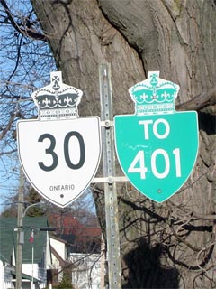
King's Highway 401 (Autoroute
Macdonald-Cartier Freeway) |
| Municipality of Brighton |
Hilton |
7.1 km / 44.0 km |
Northumberland Road 21 |
| Municipality of Brighton |
Cedar Creek |
--- |
----- |
| Municipality of Brighton |
----- |
11.4 km / 39.7 km |
Wooler Road (Northumberland Road 41, formerly
28) |
| Municipality of Brighton |
Orland |
--- |
----- |
| Municipality of Brighton |
----- |
15.3 km / 35.2 km |
Northumberland Road 27 |
| Municipality of Brighton |
Codrington |
--- |
----- |
| Brighton - Trent Hills Boundary |
----- |
21.9 km / 29.2 km |
Northumberland Road 29 |
| Municipality of Trent Hills |
Meyersburg |
25.9 km / 25.2 km |
----- |
| Municipality of Trent Hills |
(Former) Campbellford South Limits |
31.7 km / 19.4 km |
----- |
|
At Bridge Street: NB: Turn
left on Bridge Street towards Havelock. SB: Turn right on Grand Road
towards Highway 401 |
| Municipality of Trent Hills |
Campbellford |
32.8 km / 18.3 km |
Bridge Street (Northumberland Road 8) & Queen
Street (Northumberland Road 50) |
| Municipality of Trent Hills |
(Former) Campbellford North Limits |
33.9 km / 17.2 km |
----- |
| Municipality of Trent Hills |
West Corners |
35. 8 km / 15.3 km |
Northumberland Road 35 |
|
Northumberland - Peterborough
County Line: In Peterborough Highway 30 is now known as Peterborough
Road 30 |
| Trent Hills - Havelock-Belmont-Methuen Boundary |
Trent River |
47.0 km / 4.1 km |
Peterborough Road 42 (formerly 36) |
| Township of Havelock-Belmont-Methuen |
(Former) Havelock South Limits |
50.1 km / 1.0 km |
----- |
| Township of Havelock-Belmont-Methuen |
Havelock |
51.1 km / 0 km |
King's Highway 7
(Ottawa Street) |
|
Highway 30 ENDS |